December 4, 2022
December 4, 2022
We woke early this morning in the small town of Turangi. We are going to explore our last New Zealand Great Walk, the Tongariro Northern Circuit. We are hiking the most famous section, the Tongariro Alpine Crossing, often lauded as the best day hike in the country. Weather plays a crucial role, so I set aside two days in the schedule. The trail is often closed because of cold, wind, low visibility, or volcanic activity! Luckily the forecast for today was sunshine, so last night we quickly made a reservation for a shuttle transfer.
 After gearing up, we drove twenty minutes to the Ketetahi Parking Lot near the finish of this one-way track. We couldn’t get a reservation in the parking lot so we just parked alongside the nearby highway. We are way early for our 8:30AM shuttle. Aimee sweet talks the bus driver and he makes room for us on the 7:30AM which is just leaving. This bus transfer takes us to the Mangatepopo Parking Lot at the start of the Crossing track. If everything works out we will end our 12.5 mile hike where we left our car at Ketetahi.
 From the Mangatepopo road end, we began our trek just after 8AM. It is an easy stroll through a lava field. We are in Tongariro National Park which consists of the several volcanoes that make up the center of the North Island. The Park is also a World Heritage site. We reached the small waterfall of Soda Springs after an hour.
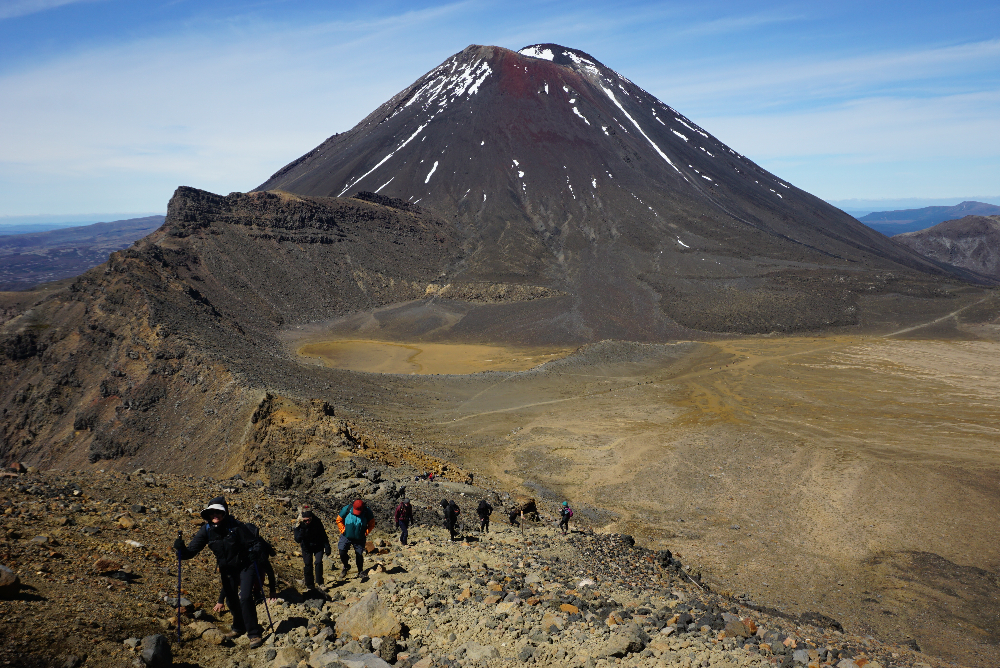
 The track now climbs towards the volcano, Mt. Ngauruhoe. It is the picture perfect volcano. Cone-shaped, dark and still very active. It is also known as Mt Doom, because it played that role in the climax of the movie, Lord of the Rings. The filmmakers couldn’t have picked a better location. Aimee and I are feeling blessed during the ascent. We have blue skies and the weather is mild. I didn’t need to bring along all the emergency cold-weather clothing that the park recommends. We get nice views to the west, especially to Mt Egmont, on the far western shore. That volcano is the Mt Fuji of New Zealand.
It takes an hour of climbing to reach South Crater at the foot of Mt. Doom. We stop and have our first rest break and snacks. So far we are not overly impressed with this trail. A breeze picks up as we walk toward the Red Crater Ridge. The breeze is chilly but I don’t think it warrants adding any layers.
 The track now ascends to the top of Red Crater, the high point of the Crossing. It is exposed so I figure it will get a little cooler and I add my raincoat as a windbreaker. After only a hundred yards the wind picks up to almost gale force and the wind chill drops precipitously. We have to stop in the shelter of a rock and put on every layer we have including winter gloves. We tighten the straps on our hats. It is a brutal hike up a loose rock field. We plow through and reach the top (elev. 6200 ft) in less than a half hour. Aimee said she saw one lady’s ball cap fly right off the cliff. I can’t imagine what this section would be like in bad weather. No wonder the park reinforces the weather alerts.
 Almost as soon as we crest the top of the Red Crater and begin our descent, the wind dies and the temperature increases. The back side is one giant rock and gravel hill. Many people are finding it treacherous. I think it is a piece of cake, like running down a sand dune. Soon Aimee also learns to dig her heel in and she calms down. One side of the Red Crater is missing, exposing the bright red iron oxide of its center. It deserves its name.
 The descent from Red Crater is interrupted to take photos of the Emerald Lakes that sit at the bottom. They are very picturesque in contrast with the gray and black volcano colors. In the distance is Blue Lake. These lakes are old explosion craters that have filled with mineral-rich water. We take our time and take lots of photos.
 Since we are not yet halfway, we need to keep pushing on. Another half hour puts us across Central Crater to Blue Lake. It is large but loses it blue vibrancy up close.
 I am not expecting much on this second half. I assume it is just a long walk back to the car. I am pleasantly surprised at the final crest to see a scenic vista with several large lakes in the distance.
 The descent off the back of this volcanic mountain is long and winding. It doesn't help that I have to stop and take photos frequently. Besides the distant lakes, there is hissing steam in several directions. This backside also seems to have lots of native vegetation, especially large expanses of Red Tussock grass. I recently learned about this native grass at a conservation area in the South Island.
 It takes hours but eventually we get below the alpine tussock region into some bushy alpine region. That gives way to forests. The descent is taking us through many biomes. This hike is not wanting to end. Stopping to take a photo occasionally takes my mind off of the marathon walk. Even when the official track does finally end at Ketetahi Road end, we have amost a mile down the road to where our car is parked on the highway. By the bottom my toes are hurting from all the downhill pounding. My personal GPS says we walked 14 miles compared to the 12.5 on the brochure. I have been long suspecting Kiwi miles were longer than ours!
We woke early this morning in the small town of Turangi. We are going to explore our last New Zealand Great Walk, the Tongariro Northern Circuit. We are hiking the most famous section, the Tongariro Alpine Crossing, often lauded as the best day hike in the country. Weather plays a crucial role, so I set aside two days in the schedule. The trail is often closed because of cold, wind, low visibility, or volcanic activity! Luckily the forecast for today was sunshine, so last night we quickly made a reservation for a shuttle transfer.


It takes an hour of climbing to reach South Crater at the foot of Mt. Doom. We stop and have our first rest break and snacks. So far we are not overly impressed with this trail. A breeze picks up as we walk toward the Red Crater Ridge. The breeze is chilly but I don’t think it warrants adding any layers.


posted by Mike and Aimee at 7:08 AM
![]()
![]()

0 Comments:
Post a Comment
<< Home