Tuesday, June 30, 2009

June 29, 2009


June 29, 2009

Last night we listened to a local folk singer who played at the campground. This long-time resident was very entertaining and provided us a warm welcome to Alaska. I kind of like this little town we are in. It is a lawless town, literally. There are no local taxes, government, police, regulations, or lawyers. Just how I like it.

After driving so much the last week, we took the day off and didn’t drive anywhere. We spend some time planning our next steps. On most maps Alaska is just a small inset. But that is deceiving. Alaska is a monster state, bigger than Texas and California combined. Alaska also has more coastline than the rest of the US. Unfortunately it also has the fewest roads leaving most of it unexplorable except by bush plane.

Monday, June 29, 2009

June 28, 2009


June 28, 2009

From Haines Junction, YT we continue our Alaska Highway journey. The road west of here is noticeably worse. Lots of frost heaves cause the highway to undulate. The up and down is not too bad, but the side-to-side rolls give me and our top-heavy rolling-house the willies. Apparently Canada maintains the highway east of here because it is well used by Canadians. West of here, the highway is used mostly by Americans traveling to and from Alaska, so the US has to contribute to its maintenance. Even with that support it lags. Nevertheless I am thoroughly impressed at the overall condition of the Alaska Highway and the amount of traffic on it.

Unfortunately the weather is still depressing… cold and rainy. We get fifteen minutes of blue skies at the start just to tease us with a glimpse of the beautiful snow capped mountain scenery we are missing. I am hoping we are luckier on the return trip.

In the afternoon, we finally make it to the Alaska border. Like the shining land that America represents, the sun makes a miraculous appearance and it is noticeably warmer. Yes!!!!!!!

Fairbanks is still 300 miles ahead but now that we have warm dry weather, we are in no hurry. We drive for another hour and stop for the day in the small town of Tok. It truly feels like we just came out of the bush and we are back in civilization.

June 27, 2009


June 27, 2009

Last night was miserable. After dinner we killed at least a dozen mosquitoes inside the RV. They are thick and hungry outside but how are they getting inside? I am envisioning some kind of hole underneath from a rock kicked up off the Alaska Highway. The mosquitoes continued to circle our heads while we tried to sleep. Between the buzzing in our ears and the bright sky, neither one of us slept. Now I am finding myself wishing for rain to keep down the attack.

In the morning we continue west on the Alaska Highway. In a couple hours we roll into Whitehorse, capital of the Yukon Territory. This town of some 24,000 holds two thirds of the territory’s population. Situated on the Yukon River, Whitehorse was in the center of the Klondike gold rush of 1898. After the hopeful gold seekers crossed the mountain pass from Skagway, Alaska they arrived in Whitehorse. Here they loaded their gear onto boats and floated down the swift Yukon to Dawson City some 300 miles north. The gold was returned here for export

In Whitehorse we stop and take a picture of the sternwheeler that used to ply the river, and then head to the Tourism Office. I ask for a map of the territory but Aimee makes fun of me as there are hardly any roads on the map and most are not paved. I also ask the receptionist about the cold wet weather and she admits that they probably already had their summer. There was a warm spell a couple weeks ago and one week is usually all they get.

After having lunch in town, we drive for another two hours west and stay at a public campground outside Haines Junction, YT. Although the mosquitoes are equally ferocious, we are more careful opening doors and we have very few inside. We must have left the door open too long last night. However I am still wondering how people enjoy the outdoors around here with all these biters buzzing around.

Friday, June 26, 2009

June 26, 2009


June 26, 2009

It rained all last night and it is still raining as we continue our journey west on the Alaska Highway. We are first slowed by a series of gravel sections under construction. Immediately afterwards we have to dodge rock slides for miles. One rock, or should I say boulder, was the size of an ottoman. In the middle of the road! The highway is now very windy and bumpy. In the first four hours we manage only 120 miles. I am not sure what we were thinking. Getting to Alaska by road is an excruciatingly long slow drive. And neither Aimee nor I like to drive, especially in the rain. We will slog thru the drive and eventually make it to Alaska, but I can already sense that the return drive is going to be painful.

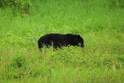
When the rain abates to a slow ooze, we manage to spot black bears along the road seven times, including a cub. The grass along the road must really be tasty. We also spot a bunch of bison and some kind of silvery long tailed fox.

For the rest of the day, we drive west bouncing between British Columbia and the Yukon Territory. Surprisingly after that tough initial section the road straightens and improves dramatically. And later in the day the rain stops and we can see the beautiful scenery. This is not a bad drive after all.

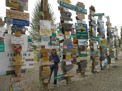
Our big stop for the day is in Watson Lake, YT. We visit the town’s small Interpretative Center on the construction of the Alcan Road. Interestingly the US built the road for $150 million and Canada paid us only $75 million for it after the war. They got a good deal. Maybe, maybe not. Apparently it was built so quickly, the Canadians had to rebuild it almost immediately. One of the original workers from Danville, IL, feeling homesick, posted a signpost of his hometown at Watson Lake. Apparently it caught on and now the town center has a forest of 65,000 signs erected by travelers following the route!

At a rest stop I talked to a Canadian girl bicycling in the other direction. We exchange stories. Hers was better. She and three girlfriends started a month ago by flying into Inuvik, an Eskimo village on the Arctic Ocean. They are headed to Vancouver and by the fall expect to finish in Newfoundland on the Atlantic coast. In comparison, our “drive” is much easier.

We stop for the night at a private RV park at Milepost 769.

June 25, 2009

June 25, 2009

After seeing the Milepost 0 monument for the Alaska Highway and reading about its history, Aimee and I decide to go for it. The highway is two-lane and relatively smooth. Considering where we are I would say it is pretty good. We have traveled Wisconsin roads in far, far bumpier condition. The drive starts by crossing the Peace River and we see sunshine peaking thru the clouds up ahead. Finally we might have sunny weather again! Unfortunately the rain catches up to us and doesn’t stop. The landscape is monotonous in the rain. Pretty much nothing but endless rolling hills of fir trees with a few aspens thrown in.

At Milepost 357, we stop for the evening and listen to the rain pound our roof. It is hard to sleep. At this time of the year in the far North, the sun barely sets. It is late at night but it is still as bright as the middle of the day.

Wednesday, June 24, 2009

June 24, 2009


June 24, 2009

From Jasper, AB we take the Bighorn Highway north across the foothills of the Rockies and back down into the Alberta plains farmland. It was an uneventful drive except for two animal encounters. We spotted a black bear running across the road into the woods and we barely missed hitting a dear. Gotta keep an eye out for Canadian wildlife when driving up north.

In Grande Prairie we take a hard left turn and an hour later we are in Dawson Creek, British Columbia. Dawson Creek is famous for being the start (Mile 0) of the Alaska Highway. Built in eight months in 1942, it was a rush project because after the bombing of Pearl Harbor, the US feared the Japanese would next invade Alaska. Prior to its construction the only way to get supplies to Alaska was by ship or airplane. I wonder if we can take an RV all the way to Alaska on this Highway? It says 1523 miles to Fairbanks. Can Alaska still be that much further? We are already 2200 miles from Tucson.

June 23, 2009


June 23, 2009

We are heading north from Drumheller, AB. Since the dinosaurs were for me, we opt for a detour and take the scenic route thru the Canadian Rockies. Many years ago I drove this route from Calgary thru Banff up to Jasper for business and I thought it the most beautiful drive I had ever taken at the time. This time the conditions are not as perfect. There are low clouds hiding the mountaintops and we are hit with intermittent rain all day. Despite the setback it is still a beautiful drive. The lakes and streams are full of glacial till giving them an iridescent teal color. The snow-capped mountains lining the route rise precipitously from the valley floor like Wyoming’s Grand Tetons but these go on for some two hundred miles.

Beside the scenery, Banff and Jasper National Parks are also full of wildlife. Alongside the road we see two black bears. Then later we see crossing the road a group of mountain goats, a herd of Big Horn sheep and a moose. All had babies with them.

To get some exercise on this long driving day, we stop for short hikes to Peyto Lake overlook, another to Mistaya Canyon, where a river gushes thru a tiny gorge, and the last to the foot of Athabasca glacier. Since the last time I was here, around 1998, the glacier has receded some two hundred yards. After driving and stopping all day we pull into a park campground just south of Jasper.

Monday, June 22, 2009

June 22, 2009


June 22, 2009

Most of the modern fossil discoveries from Dinosaur Provincial Park have all been shipped to the Royal Tyrrell Museum. So we follow the Red Deer River valley upstream past long stretches of Badlands to Drumheller, Alberta. This museum is famous and deservedly so. It is huge and has to be by far the largest paleontological museum we have seen. It is also well done. We could have spent all day here and we almost did. This was mostly my doing. The highlight of Aimee’s day was when we took a break halfway and walked back to the “house” for a Hot Chocolate break.

June 21, 2009


June 21, 2009

From Shelby, MT we crossed the border into Canada and drove straight north thru flat-as-a-pancake farmland that would rival Kansas for how far you can see. We are headed for Canada’s Badlands but I can’t believe they can be around here. After a couple hours we pull into or rather descend into Dinosaur Provincial Park. There they are. The Badlands. The colorful eroded cliffs occur where the Red Deer River has cut a deep channel thru the prairie.

In the Visitor Center we learn that this area has been the richest source of Cretaceous fossils in the world. We sign up for a Lab Talk where we learn to identify many kinds of fossils. It doesn’t help. We take a couple hikes off the auto loop and all we collect is mud. The slippery version. The Badlands mostly consist of sand and clay. Apparently some kind of volcanic clay that when wet (it rained all the way here) becomes as slippery as ball bearings. In fact they sell it as an oil drilling lubricant. I did find what I thought was a claw until I washed away the mud. We spend the night at the campground in the park.

June 20, 2009


June 20, 2009

Before leaving Great Falls, MT we drive to the Missouri River to look at the waterfalls that Lewis and Clark had to portage around on their expedition. Lewis only planned spending a half-day to drag their boats around this Great Falls of the Missouri. Unfortunately for him there turned out to be four waterfalls. It took the Corps of Discovery a month to portage the 18.5 miles around the set. And unfortunately for us, Montana has put a series of dams along this stretch submerging one and spoiling the view of the other three falls.

After looking at one of the falls we encounter a Lewis and Clark Interpretative Center . We stop for a quick look but end up spending most of the day there. It is nice and huge. Well worth the stop in Great Falls. We have followed snippets of the Lewis and Clark trail but at some point I would like to follow the whole thing. Every time I read about the journey, I am amazed at the accomplishment. Both Lewis and Clark both kept journals of their Big Adventure. I guess that is where I got the idea.

Late in the afternoon we head out of town and stay at a public RV park in Shelby, MT just south of the Canadian border.

Friday, June 19, 2009

June 19, 2009


June 19, 2009

Yesterday we learned about the plight of the Indians. Today in our bid for objectivity, we go after the cowboy’s story. From the Big Hole valley we travel to the Grant-Kohrs Ranch National Historic Site. This site is a working cattle ranch dedicated to the history of open range ranching as it was practiced here in the second half of the 1800’s. I must admit I wasn’t expecting much. I saw plenty of farms growing up. Nonetheless it turned out to be interesting. The primary owner, Conrad Kohrs, a German immigrant was the ultimate cattle baron of Montana. At the peak he had cows grazing on 10 million acres of mostly public lands, was heavily involved in Montana politics, and invested in local mining operations. Cattle ranching in the West evolved over time. It started as a trading opportunity supplying Oregon Trail immigrant with fresh oxen. Later the ranchers expanded to feed hungry miners. Soon ranchers were driving excess cattle to faraway Dodge City. Eventually rail lines reached Montana and then the industry took off supplying eastern cities with beef. To this day Montana is still ranch country with some mining operations thrown in.

Aimee and I spend a couple hours moseying in and out of the many ranch buildings and then take a tour of the huge ranch house. The tour docent is surprisingly a descendent of the “real” Rip Van Winkle. Afterwards we make our way back to I-15 and drive north through very scenic countryside. Montana would be a beautiful place to own a small ranch. But who am I kidding; ranching is very hard work. We spend the night at a private RV park in Great Falls, MT.

June 18, 2009


June 18, 2009

From Pocatello, ID we continue our journey north intermittently hitting rain showers. In one short week our journey has single-handedly broken the back of the multi-year drought the West has been enduring. Hmmm…I wonder if we can make money as professional rainmakers?

In a long day of driving we pass by the vast lava fields of southern Idaho and cross into Lewis and Clark’s Montana and the headwaters of the Missouri River. In the afternoon we arrive at Big Hole Battlefield just east of the Idaho border. Big Hole was the site of the largest of the Nez Perce War battles. The Visitor Center chronicles the struggle of the Nez Perce Indians as they resisted being forced onto a smaller reservation. The story is sad but inevitable. Like the majority of Indian tribes they led a nomadic Stone-Age lifestyle requiring vast tracts of land for survival. Once the New World was discovered, it was only a matter of time before they were all overwhelmed by the expansion of modern civilizations.

After learning the history, Aimee and I hike out to the site of the skirmish. When Aimee first glimpses the lush green hillside leading up to the hilltop, she just wants to run up the slope. When we get closer, she finds it less inviting. It is super steep and full of weeds.

Leaving the battlefield we follow the rain-swollen Big Hole River east. We are tired of driving and the next published campground is an hour away. Almost miraculously we stumble upon a small one along a particularly stunning stretch of the river. We park in the middle of a grassy field right next to the river. One of the most beautiful sites we have had. And the fee is only five dollars! Now if the river level was just a little lower and I had a Montana fishing license, it would be the Garden of Eden.

Wednesday, June 17, 2009

June 17, 2009


June 17, 2009

After we settled in last night, two more RV’s joined us. No matter what off the wall spot I find, Aimee is always amazed that we are NEVER the only nuts.

We wake to rain and cool weather again. Seems the norm for our vacations lately. Driving north we are amazed at the beauty of the side canyons off Flaming Gorge. This National Recreation Area is on our list to visit again albeit later in the summer. Descending out of the Uinta Mountain chain and crossing into Wyoming we make a stop at Fort Bridger State Historic Site. Jim Bridger started his career as a mountain man hunting beaver pelts. Seeing European fashion wane from Beaver skin hats he setup a trading post here along Groshon Creek to service immigrants moving west. His foresight didn’t last long. Soon most trails edged further north to the point he was selling only to Mormon pioneers. Brigham Young, Mormon leader and Utah territory governor, became envious of his business and organized a militia to drive him off. Bridger got the last laugh. When the Mormon Wars broke out a few years later he guided the US army back to the area.

We spend the rest of the day driving thru intermittent rain ending up at a RV park attached to a Shoshone Indian casino outside Pocatello, ID. The rain breaks long enough for us to get the RV hooked up.

June 16, 2009


June 16, 2009

Before leaving Vernal, UT we stop briefly at the Utah Field House of Natural History. I figure since a large dinosaur quarry is close by, the fossil collection has to be good. I am not disappointed. Although the museum is relatively small it is well designed and filled with lots of fossils.

From Vernal we drive north. Soon after, we pass a sign for Red Fleet State Park and a sign for dinosaur tracks. I can’t just drive by. A couple miles off the highway we hike three-miles to the edge of a reservoir lake. Unfortunately almost all the tracks are below the water level. We need to come back during the dry season. There is only one dino footprint visible. Even though the field expedition is a bust the hike is very pretty going thru red and white rock canyons that remind us of Capital Reef National Park in southern Utah. All the layered rocks in this area have been uplifted to almost vertical so we are either treading over the ends or carefully sliding down steep slick rock.

Back in the RV we continue north climbing up the Uinta Mountains to Flaming Gorge National Recreation Area. Flaming Gorge is a lake formed by a dam on the Green River. Passing Elk and Big Horn sheep, we stop at the Visitor Center for information and we are greeted with a great view of the 1800-foot canyon bordering the lake. Beautiful. We park for the evening at a nearby campground. Our site is literally feet from the sheer cliff edge. We are also the only ones here, and at 8400ft elevation, it is freezing. Summer comes late to the mountains.

Monday, June 15, 2009

June 15, 2009


June 15, 2009

Today we are setting out on a whitewater raft trip down a section of the Green River that runs through Dinosaur National Monument. This stretch goes thru Split Mountain and is supposed to have several sections of whitewater rapids. I am a little worried because we wake to low 50’s weather. This combined with ice-cold snowmelt river water could make for an unpleasant trip.

We meet our river guides just outside the park where we are assigned life vests and crash helmets. We then load up on a school bus for an hour ride down a dirt road to the other side of the park. Along the way we stop and see a large assortment of Indian petroglyphs on the cliff walls. We also talk to the river guides and discover all but one are University of Arizona geology graduate students from Tucson. I sure missed out on all the cool summer jobs when I was in college. They tell us that the water level is way higher than normal and we are in for a wild ride.

At the raft put-in we get a safety lecture about how not to die from hypothermia while swatting away a horde of seriously hungry mosquitoes. Once on the river, it turns into a glorious day. It is warm, sunny and the scenery stunning. It is like floating down a miniature Grand Canyon. Because of the high water level, the run is whitewater almost the whole way. There are a few hairy spots but the guide is pretty good and we go thru them with a breeze. We stop partway thru the trip for a shore lunch. After paddling and being sprayed with cold water, we are ravenous and the food delicious. The downside of the high fast water is the trip comes to an end far sooner than we are ready.

As we rafted I was reminded of John Wesley Powell’s epic journey down the Green and Colorado Rivers in 1869 to map this final blank spot on the US map. I always assumed it was a grueling trip. Based on what we saw today he had a stupendous time. (Albeit he never knew whether a large waterfall loomed just ahead)

Sunday, June 14, 2009

June 14, 2009


June 14, 2009

A BYU professor has opened up a new dinosaur fossil dig site across the valley from the original quarry at Dinosaur National Monument. The only way to visit this “active” site is on a ranger-led excursion. So we return to the Visitor Center at 10 AM this morning for the hike. It is well worth it. The paleontologist used dynamite to clear away rock leaving a dozen bones now exposed. The university team plans to return this Fall to extract the bones when cheap student labor for the heavy lifting is readily available. In the meantime I get to see the bones partially exposed.

After the hike we head into the nearby town of Vernal, UT to restock our covered wagon. We spend the afternoon at a private RV park in town where Aimee does laundry while I use the Internet to catch up. Aimee likes having all the luxuries of unlimited electricity, plentiful water, high speed Internet, and cable TV of a private park. “Roughing it” for us is when we only have battery power and a 50-gallon tank of water.

June 13, 2009


June 13, 2009

We wakeup to rain again! It is not supposed to be raining this much in Utah. Last night’s rain was also accompanied by lightning. One bolt exploded with such fury that I swore it was next door. Nevertheless we don’t see any evidence of a hit in the neighborhood. I guess all noises are accentuated living in a tin can.

From our campground in the Uinta National Forest we make the most beautiful drive up and over the mountain ridgeline. Our view alternates between snow-capped peaks and an endless forest of white-trunked Quaking Aspen trees. Heavenly! Utah is definitely high on our list as the most scenic state in the Union.

After descending from the mountain we drive for several hours past rolling green hills that decay into gray barren ones. We found DryLand! We also found Dinosaur National Monument. This park preserves a small area where hundreds of dinosaur fossils have been found. From the temporary Visitor Center we take a mile-plus hike along an eroded cliff where we spot a dinosaur leg bone and spinal column sticking out of the rock. That is all the dinosaur bones I get to see. I am very disappointed to learn that the park’s centerpiece is closed. The main Visitor Center houses a rock wall containing hundreds of dinosaur bones awaiting excavation. The building was closed in 2006 because of subsidence problems. After three years the NPS has finally gotten funding to repair the building starting next Spring. Our wonderful legislators waste trillions every year but can’t find a few dollars to protect our national heritage. Depressing.

Besides being a dinosaur quarry, the park is also home to some interesting scenery. In this locale the Green River carved a canyon thru the middle of a large domed mountain. We find a campsite along a flat stretch of the Green River facing this domed monolith and enjoy the dry warm weather.

June 12, 2009

June 12, 2009

From Provo, Utah we drive north along I-15. The mountains to our immediate right are spectacular…. high, craggy and snow covered. After only a few miles we exit and head uphill into American Fork Canyon, a narrow gorge in the Wasatch Mountains. Our destination is Timpanogos Cave National Monument. We sign up for the next tour. Unfortunately the cave entrance is 1000 feet above our head. After packing a few snacks and a jacket we head up the steep but well-paved trail. It is a strenuous hike and we are surprised at how popular it is. Especially by young families with several small kids in tow and on their back. But I guess this is Mormon country.

We make it to the cave entrance well in advance of our tour time. We rest a little while to let some sweat evaporate and then join a tour. It is a small but nice cave and the tour is interesting. But neither Aimee nor I are big cavers. We both prefer the views of the steep narrow canyon outside the cave. We like the canyon so much we decide to find a site in one of the campgrounds in the adjoining Uinta National Forest. It is Friday and crowded but we are successful. We spend the night in the shadow of a jagged glacier-carved snow-capped peak.

Thursday, June 11, 2009

June 11, 2009

June 11, 2009

It rained all night. That travel rain cloud of ours has followed us even into the desert. It is also cold. It got down to the low 40’s last night. I was looking for an escape from the heat and I found it. Be careful what you ask for. I was hoping to drive to Wheeler Peak here in Great Basin National Park and hike around but the summit is in the clouds and probably getting more snow. So we punt and drive northeast into Utah where we stay at a private campground in Provo.

June 10, 2009


June 10, 2009

From Valley of Fire in southern Nevada we head north along the Great Basin Highway. We drive most of the day thru mostly desolate areas before arriving at Great Basin National Park. The Great Basin Desert encompasses most of Nevada and is the country’s only cold desert. I can attest to the cold. It is in the low 60’s and breezy. Compared to Arizona and Las Vegas this is downright freezing. Another distinguishing feature of the Great Basin is the lack of river outflows. Despite the high elevation, the little bit of rain that falls in the region stays here, ending in salty inland seas or marshes.

The Great Basin is crossed with a series of parallel mountain ranges. Although the valleys are mostly dry flat sagebrush expanses, the mountains are pretty and islands of fertility. After spending some time in the Visitor Center, we pick out a campsite nestled in a forest of Quaking Aspens. It is also starts to rain. You would never think we were in the middle of the Great Basin desert.

Tuesday, June 09, 2009

June 9, 2009


June 9, 2009

Last night we walked the Vegas Strip to check out all the new resorts since our last vacation here almost twenty years ago. It is totally changed… again. Pirates and castles are out, Old World is in. The famous landmarks of Paris, Venice, Rome, and Egypt have been meticulously recreated here. In some ways they are nicer than the real thing: cleaner and newer without the flaws. Plus they are all within walking distance of each other!

At 9:30 we catch one of the Cirque du Soleil shows, Mystere. I have wanted to see what all the hype has been about. The show was an eclectic mix of acrobatics and dance set to music and lightshow interspersed with comedic skits. For me it started slow but ended well. We almost missed seeing the performance though. We showed up at the wrong hotel. The booking number we called failed to tell us this version was playing at a different hotel. Good thing we were early.

Since we were up late last night we tried to sleep-in this morning. We depart Vegas and head northeast of town to Valley of Fire State Park. After driving thru a desolate desert stretch we turn a corner and head downhill and suddenly are faced with brilliant red rocks springing out of the otherwise gray landscape. With imagination the red rocks do look like flames roaring out of the valley floor. We spend a couple hours exploring and climbing the honeycombed red rocks in the park. We also see loads of Indian petroglyphs etched into the rock walls. We call it a day early and laze around a very nice campsite nestled within some red boulders.

June 8, 2009


June 8, 2009

From Buckskin Mountain we follow the Colorado River north. The river is lined on both sides with an almost continuous set of campers and boaters. The river has a series of dams on it to provide pools for water storage. Lake Havasu formed by Parker Dam supplies water to faraway Tucson and our apartment. We stop in the center of downtown Lake Havasu City to snap a few photos of London Bridge while Aimee starts humming “London Bridge is falling down”. Somehow when this bridge started falling apart in London, the Brits got the bright idea to sell it and amazingly somebody bought it. It was moved here in the middle of the desert piece by piece forty years ago. It is nothing special.

Continuing north we drive over Hoover Dam, the granddaddy of Colorado dams. From the heights of Lake Mead National Recreation Area, we get great views of the challenging construction environment of Black Canyon. Because of 9/11, our RV is searched before we are allowed to cross. A cool looking bridge is being built just downstream to divert all future dam traffic. I have taken the Hoover dam tour before so we continue on north to Las Vegas, where we get a campsite a block from the strip behind the Circus Circus casino. The West is very RV friendly.

June 7, 2009


June 7, 2009

We are celebrating D-Day today. We may be a day late but for us it means Departure Day and the start of the fourth year of Our Big Adventure. It seems harder this year for some reason. We are keeping the apartment so we didn’t have the imminent end of our lease to prompt our leaving. In the past we would have the movers pickup our rental furniture and anything left over went in the RV. This time we had to go thru every room deciding what went and what stayed. I hope we didn’t forget anything important.

We woke early to finish loading before the Tucson mercury rose to triple digits. By eleven we were finished and on the road north in search of cooler temps. Several hours later we left the interstate at Quartzsite, AZ. In the winter this little town in the middle of nowhere rocks (pun intended) with RV-ers. Today it is very sleepy. From Quartzsite we head north till we run into the Colorado River. The river is a thin oasis of blue and green in an otherwise very dry and rocky landscape. It has been a long day so we stop and spend the night at Buckskin Mountain State Park. After grilling steaks we sit at our campsite along the river watching the sun set in a blaze of red.
Newer Posts Older Posts