Thursday, September 28, 2006

September 26, 2006

September 26, 2006

We are up early today as we have a lot to see in Williamsburg. Williamsburg was the capital of the Virginia colony during Revolutionary times and the site of much history from that era. Shortly after the start of the Revolution, Virginia moved the capital inland to Richmond to hopefully provide more protection from sacking by the British Navy. The city of Williamsburg then went into decay. During the depression, the Rockefeller family donated money so that the entire town would be preserved for history. The site is now managed by a private non-profit foundation.

A ticket into Williamsburg is very expensive but is well worth it. They have reconstructed much of the town, but what makes it special is the very knowledgeable staff, all in period costumes, who pretend to be from Revolutionary times. We start in the Visitor’s Center and watch an old movie starring a young Jack Lord (of Hawaii 5-0 fame) as a Williamsburg resident and Virginia legislator trying to make up his mind if he is going to vote for Independence or not. It is a very good film and sets the stage for touring Williamsburg. From there we make the fifteen-minute walk into Colonial Williamsburg. We first join a tour of the Governor’s Palace. The mansion is nice but the guide brings it alive and relevant. It started off as the home and office of the British-appointed governor. After the last British governor fled at the beginning of the Revolution, the home was occupied by Patrick Henry (Give me Liberty or give me death) and Thomas Jefferson, the first and second governors of the new Virginia Independent State.

From there we walk down the main street visiting the Church and some of the craft shops. At the far end of town we tour the Capitol Building. The guide for the capitol is awesome. The colonial government mimicked the British Parliament exactly with a House of Lords and a House of Commoners because most colonists considered themselves full British citizens. It wasn’t until England began treating the colonies as conquered states that talk of Independence arose.

From there we stop at one of the taverns for an outdoor lunch. During lunch, Aimee gasps with terror as she sees a mouse dart under the ivy-covered lawn. Later we find that the man who runs all the restaurants was eating nearby and comp’d our meal. That pet mouse Aimee carries around finally pays off!

After lunch we tour the gaol (jail). Crime was relatively low as the sentence for any significant crime, including theft over 25 shillings, was hanging.

At 2:30 a dozen period-costumed actors migrate to one end of the town and recreate the day that British authority dissolved the Virginia legislature and set Virginia on the road to declaring independence. It is amusing and well acted but Aimee and I find it slow and somewhat repetitive as we have heard the story now a few times from the movie and the tour guides. We instead walk back thru the town touring more of the buildings. I especially like the gunsmith and the armory.

Beyond the west end of the town sits the College of William and Mary. It is the second oldest college in America (after Harvard) and was here before the town of Williamsburg. We tour the oldest building, which has some historical exhibits and restored rooms from its early days. Three of our presidents including Jefferson attended the school. The school gets its name from the English king at the time of charter, William of Orange and his queen Mary.

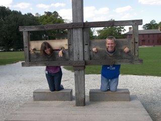
By now our feet are sore and the park is closing so we head back. We haven’t seen everything but probably enough not to warrant a second day. Besides, Aimee and I got falsely accused of treason today and spend some time in the stocks. We don’t want to give the town a chance to reconsider our innocence.

Monday, September 25, 2006

September 25, 2006

September 25, 2006

This morning we drive the few miles back towards Charlottesville and stop at the Thomas Jefferson Visitors Center. The Center has a 45-minute film on his life and some museum exhibits on each period of his life. Jefferson was a true Renaissance man. He was the author of the Declaration of Independence, a major politician in the birth and early life of the US, an amateur scientist, self-taught architect, a farmer and plantation owner, and a philosopher. Amazingly despite all his accomplishments and his being a large landowner in this area he died heavily in debt, and all his possessions were subsequently sold at auction.

From the Visitors Center we drive across the highway and up to his beloved home he called Monticello. The name means ‘little hill’ and accurately describes its location. From this little hill, the home has a beautiful view of the surrounding countryside. We first get a tour of the home's inside. It is stuffed with memorabilia from the return of the Lewis and Clark expedition he authorized and from his time in Paris serving as envoy to King Louis XVI (he witnessed the storming of the Bastille). Jefferson was an avid reader. Monticello would have had many more books (6000!) but he donated most of them to the US to restart the Library of Congress after the British burned Washington DC in 1814. The tour ends in the large backyard and the famous view of Monticello seen on the back of the nickel. After taking a picture we join a tour of his gardens. The gardens are nice and contain flowers of all kinds. I am most fascinated by a Mimosa vine. Known also as the Sensitive Plant, its fern leaves fold up at the slightest touch. Magic! Jefferson designed both the house and the landscaping. Uniquely, the plantation back offices (stables, kitchen, smokehouse, servants quarters are all hidden from view behind sunken wings that extend from either side of the house.

From the backyard we take the long way back to the entrance passing by TJ’s grave. His gravesite is now the location of a family plot for any direct descendent of Jefferson. The family association that runs the cemetery plot does not allow the burial of any descendents of Jefferson’s probable association with his slave and companion Sally Hemings.

From Monticello, we drive southeast past Richmond to a campground outside Williamsburg. There we have a long talk with another traveler from Chicago and get a lot of ideas for places to see in the near future.

September 24, 2006

September 24, 2006

This morning we drove out of DC south towards Virginia. We pass what looks like a mirage over the trees, like the castle out of the Wizard of Oz. The castle is pale white with gold tipped spires; it blends into the overcast sky making it shimmer. Aimee looks on the map and it turns out to be the Washington DC Mormon temple. The Mormons definitely have very unique architectures for their churches.

About 25 miles south of DC we get off the highway near the town of Manassas and head for the Battlefield Park. This area was the site of two battles of the Civil War. The South named their battles after the closest city (i.e. Manassas) and the North after the closest natural landmark (i.e. Bull Run). At the Visitor’s Center we watch a movie about the battle and look at their displays. They have a nice battlefield map with animated lights that illustrate the events of the battle. We also listen to a Ranger talk and walk around the central part of the battle site. The first Battle of Bull Run (or Manassas to my southern readers) was the first major battle of the Civil War. Both sides expected the war to be over quickly. The first Union recruits were only signed up for three months. Spectators from both sides came along with the troops to watch this first (and maybe last) battle. Everybody was aghast at the bloodiness of war and the fierce determination of the other side. This war was not going to end quickly or easily.

The North’s goal was to march south 100 miles from Washington and take the Confederate capital of Richmond, VA. In the way was the Manassas railroad junction. Both sides rushed to this spot with troops eager for battle. The first few Southern troops spread out on the southwestern bank of the local river, Bull Run. The North did an end run around sending half the army to cross Bull Run upstream. It was successful at first, but the North failed to press their advantage, and the South was able to bring reinforcements in position. One of the reinforcing units was commanded by General Jackson and his defense here gave him the legendary nickname of Stonewall. The battle would have ended in a stalemate except a rear-moving Union troop movement incited a general panicked retreat by the Union.

Before leaving the area we drive to the east side and see the main stone bridge over the Bull Run. After spending four hours at the site, we drive southwest to the outskirts of Charlottesville, home of the University of Virginia. The route goes thru some beautiful wooded country with green mountains in the distance to the west.

Sunday, September 24, 2006

September 23, 2006

September 23, 2006

Today we again went down to the Mall to finish our tour of the Smithsonian Museums. There are many Smithsonians spread out around Washington. We are interested and only have time for a few. The Metro stops next to the National Archives so we run in there first. They have an exhibit on eyewitness accounts of important events in history. Aimee finds it interesting and I eventually have to drag her out. We then take a quick peak at the original Constitution and Declaration of Independence. Disappointingly the Declaration of Independence is so faded and blurred that it is now unreadable. Even John Hancock’s large flashy signature! We later learn that it started fading soon after it was written and an engraving of it was made in 1823 so its look could be preserved.

We then walk to the Natural History Museum and spend a few hours breezing thru the exhibits. It is pretty good but we don’t really have the desire to spend days in this museum alone. One amusing area is the Insect Zoo. They have some live specimens of unusual bugs. They even have a petting zoo where you can hold some of these creatures. Aimee though doesn’t want anything to do with voluntarily touching a giant cockroach.

We walk towards the American History Museum but it is closed for renovations. We only have an hour or so left before the museums close so we make a run thru the one of the many Art Museums. They have a nice general collection but I would have thought they would have had a larger section of American artistic works. They don’t.

September 22, 2006

September 22, 2006

This morning we head south of downtown DC, across the Potomac River to Arlington Cemetery. Our first stop is the Visitor’s Center to pick up a map. We then walk to JFK’s grave. The eternal flame is alit above the headstone. Thirty yards to the left is also RFK’s grave. From here we head up the hill towards what looks like a Greek temple. It is Arlington House. Arlington was once the home of Robert E. Lee. At the beginning of the Civil War, when Lee resigned his Army commission and joined the Confederacy, his property was seized by the Union Army. They immediately began burying Union soldiers next to the house. Unfortunately the house was never owned by Lee but by his wife, who was not an enemy combatant. In the late 1870’s his ancestor’s successfully sued for the return of the property but at this point had to settle for a payment from the government. We tour the antebellum house. The house has a beautiful view overlooking DC. What looks like sandstone columns with a marble top turns out to be faux painting. (And I thought that was a modern invention.) Behind the house is a small but interesting museum on Lee’s life. Interestingly Lee’s father-in-law, George Washington Custis, who owned Arlington, was the grandson of Martha Custis Washington, George’s wife. From there we walk to the tomb of the Unknown Soldier and watch the changing of the guard.

Afterwards we take the Metro back to the Mall and take a tour of the Bureau of Engraving. We watch them print and cut millions of dollars but the tour is rather boring. We finish the day at the Air and Space Museum and see the parts we missed on our first stop. This museum is huge. Even though we breeze quickly through it, we spend another two hours there.


September 21, 2006

September 21, 2006

This morning we take the Metro back down to the Mall. We head first to the White House Visitors Center. To get a tour requires you to go thru your congressman and wait for a six-month background check. We didn’t preplan this trip so we make do with the exhibits in the visitor center. We walk over to the White House for a pic from the faraway south lawn fence. There are barriers everywhere now and this is the closest you can get.

Since it is a beautiful sunny day we decide to do a little hiking and see all the monuments. They are pretty much in a circle around the Tidal Basin. We start at the Washington Monument. There is an elevator up the center but you need a timed ticket. We get one for about when we think we will finish. It is then on to the Jefferson Memorial. It is a large domed white temple with a huge standing statue of Jefferson inside. Next in line is the Franklin Roosevelt Memorial. This memorial is a very spread out structure of granite blocks, waterfalls and bronze statues from his life. We pass by the Korean War Memorial. Next is the Lincoln Memorial. This one is a huge Greek temple with a large sitting statue of Lincoln inside. By this time my feet are getting tired as these monuments are widely separated and my bones old. We have a hotdog lunch while sitting on a bench overlooking the Vietnam Memorial. The Vietnam Memorial is two black wedges set into the earth containing all the names of those who died. Refreshed we continue on to the World War II Memorial, which is a huge fountain surrounded by wreaths for each state.

Finished we make our way back to the Washington Memorial and hang out till our ticketed time. We take the elevator up the Washington Monument. It is bigger than I thought. It is the tallest stone structure in the world and was the tallest building when it was finished around 1880. (Amazingly it was started around 1833 but political in-fighting stopped construction several times!) At the top we get good views of all the surrounding Capitol buildings, White House, and monuments. On the ride down we notice the elevator has glass panels and that this monument is completely hollow. It is not as substantial a structure as I thought.

Wednesday, September 20, 2006

September 20, 2006

September 20, 2006

Our campground is very tourist friendly. There is a bus stop within the park. We hop on a bus that takes us to the Washington DC Metro system. Washington’s subway is gorgeous, the best our tax money can buy. We take the green line downtown to the Mall. We walk a few blocks to the Capitol and get a 12:30 tour ticket. It is only 10:30 so we walk to the Air and Space Museum. We browse very quickly through the 'Early Flight' section. The Smithsonian has lots of significant artifacts but we either don’t think the displays are very good or we have museum overload. We have lunch in their cafeteria and then head back to the Capitol building.

At the Capitol, we are first given a tour of the Rotunda under the main dome. It is very pretty. The tour guide spends a lot of time describing the paintings decorating the room. We then move to the original House chambers. The room is now a statue gallery. Apparently each state is allowed two statues in the building and 38 of them are stored here. We are then taken to a basement room where they have a small museum about the capitol building. We are told that to see the Senate or House chambers we need to go to one of the many Congressional office buildings and get tickets from our senators/representatives.

We figure why not so we head across the street to the Sam Rayburn building and hope we recognize one of the names. Once thru security, we find Henry Hyde’s name and head upstairs to his office. There we get both Senate and House tickets from the receptionist. Henry was too busy to see us as he was giving a speech at that moment in the House. We head back across the street and thru multiple security screenings to the viewing gallery of the House. By this time, Henry is long gone and shockingly so are most of the other Reps. Of the 435 Representatives in the House, less than 20 are in their seats. Despite the lack of an audience, the representatives there are energetically giving one-minute speeches on the merits of some law apparently requiring photo ID’s to vote. I think Henry just introduced the bill. The Republicans present arguments that this will reduce voter fraud and improve trust in election outcomes. All the Democrats say that is unconstitutional, infringes on voting rights, and is a Republican plot to reduce Democratic votes. One Pennsylvania Republican at the end voices some concerns about his Lancaster Amish community having religious objections to having their picture taken. (They didn’t seem too concerned about my taking their picture last week.) After watching for perhaps a half hour, I notice a trend. The Representatives come in, wait for their turn, give their talk and then saunter out. They don’t stay to hear the debate, only to hear themselves talk. Aimee and I both get disgusted with our government.

We get up, head downstairs and work our way to the Senate gallery. We laugh as soon we as we sit down. There is one lone Senator from Alabama (Jeff Sessions) giving some very long speech on some bill about either border security or presidential powers. Since there is absolutely no audience, this speech is for television. Just before Sessions finishes, in walks Senator Boxer from California. She starts her speech and he leaves. She immediately starts railing about Bush and Iraq and then moves into other subjects including complaining about how little the government does for cancer research or for the growing labor shortage in fresh vegetable picking. (How can California have a labor shortage and a high unemployment rate?) By this time Aimee and I are snickering about everything she is saying, especially a remark about listening to Senator Session’s speech.

When we entered the Senate gallery we were given a nice brochure on the 2006 Senate. Apparently we weren’t the only ones to question the attendance of the Senators. The brochure answers that the Senators spend most of their time on committees. I review the list of 24 committees and among others they include Indian Affairs, veteran affairs, ethics, library, printing, small business, aging, and rules. Now I know why they don’t have time to make it to the Senate floor. I wish we hadn’t gone to the viewing gallery. It burst my bubble about our government. We head back to our camp for a beer.

September 19, 2006

September 19, 2006

This morning we drove to a Park and Ride on the north side of Baltimore. From there, we take a 45-minute train ride to the downtown Inner Harbor area. We then take a water taxi to nearby Fells Point and eat a lunch of Maryland crab cakes. After lunch we hop on the water taxi and cross the harbor to Fort McHenry. Fort McHenry guards the entrance to Baltimore harbor. In the War of 1812, after the British burned Washington DC to the ground, they wanted to do the same with Baltimore; so British ships bombarded the fort for 25 hours. The fort withstood the attack. Francis Scott Key, who was in charge of prisoner exchange for the US and witnessed the event from a British ship in the harbor, wrote and published his observations in a poem. This popular poem went on to become the Star Spangled Banner, our national anthem.

After touring the fort we reverse our commute and drive the RV south to a campground outside Washington DC. We meet George Bush at the campsite and take a picture with him. He is not as tall as I imagined.

Tuesday, September 19, 2006

September 18, 2006

September 18, 2006

While checking out of the hotel, I see a brochure for the Hagley Museum. It seems interesting so I convince Aimee to backtrack a few miles to its location on the outskirts of Wilmington, DE. It turns out to be where Dupont came to this country in 1802 and built a gunpowder factory. The company eventually grew into the chemical giant we know today. The museum is located on the original grounds of the factory and has a very interesting collection. We start in the Visitor Center where they have exhibits on Dupont’s founding of the factory and its later growth.

Next we walk along the banks of the beautiful Brandywine River and see the remains of the original mills that ground, mixed, and compressed the three ingredients of black powder: charcoal, sulfur, and saltpeter. The mills were all powered by waterwheels. The mills were three sided, with the open side facing the river, so when they blew up, (which they did frequently) most of the force would be away from the town. One of the mills still has its equipment in-place and the guide activates it for us. This mill looks like a giant rotating barbell. We also get a tour of the still working water-driven machine shop. The machinery and hands-on demonstrations fascinate even Aimee. We even watch a pinch of gunpowder tested in a portable detonation device.

We then head uphill to tour the foreman’s house, the company's one-room schoolhouse and the Dupont family house. The Dupont mansion and its setting on a bluff overlooking the Brandywine are beautiful. The east coast is much prettier than I ever thought (or have seen before).

It is 4pm so we get back on the highway and head south. We stop at a campground just north of Baltimore. We are camped alongside a wide tributary of the Chesapeake Bay and the weather is clear. I have a beer and do a Sudoku while watching sea gulls dive for fish. Life is good!

Monday, September 18, 2006

September 17, 2006

September 17, 2006

We got to the Philadelphia KOA just before 7pm last night. On checking in we are told that Graham Kerr, “The Galloping Gourmet” is talking in the pavilion from 7-9 tonight. We park, eat a quick soup and sandwich, and walk to the meeting room. I was expecting a talk on cooking but instead Graham talks about lifestyle changes for healthier living. Aimee is more interested than I am. I already have made my lifestyle change and I am more surprised that he is hitting the campground circuit.

This morning, we get a late start. We head into downtown Philadelphia close to noon. We find parking for the RV at Penn’s Landing along the Delaware River. I have to pay $30, double the normal because I am taking up two parking spots. We walk the six blocks to the Independence National Historical Park to get a timed ticket for Independence Hall. Our 2:30 time slot requires us to be there by 2pm for security screening. We kill time by looking at the exhibits and watching a film at the Visitors Center. Unfortunately our inept government was having problems with their clocks and we only saw the last half of the film. The worst part is that the Visitor Center rangers weren’t concerned enough to fix the problem.

At 2pm we run through the airport-like scanners at Independence Hall. We spend the next 29 minutes, sitting, waiting for our 2:30 tour. The tour lasts 30 minutes and shows us the two rooms in the Pennsylvania State House. It is nicknamed Independence Hall because the Declaration of Independence and the Constitution were both debated and signed here.

Afterwards we walk across the street to see the Liberty Bell and its exhibits. The Liberty Bell used to be in the Independence Hall bell tower. Even though it was cracked it came to be the symbol of our country and used to travel throughout the land.

We walk to the US Mint but it is closed on weekends. Across the street we see Benjamin Franklin’s gravesite. Since it is now 4pm and most everything is closed, we walk back to Penn’s Landing. Instead of driving we take a tourist bus to Philadelphia’s Museum of Art. Along the way we are able to see some of Philly’s prettier sections. We walk to the far side of the Museum and take a picture of the “Rocky” statue and the famous steps from the movie. We plan to commemorate the visit by watching “Rocky” in the RV tonight.

We head out of town south and plan on staying at a campsite north of Baltimore. Traffic is fierce as the Eagles game just let out. It loosens up but in the middle of Delaware it comes to a crawl again. Very surprising for a Sunday night. It is 7pm, we are tired and far from a campground so we pull off at the next exit and stay at a hotel, our first since traveling by RV.

Sunday, September 17, 2006

September 16, 2006

September 16, 2006

This morning we continue our drive east. We want to do the tour of the Harley Davidson motorcycle factory in York, PA but it is closed on weekends. Bummer! So we continue on to Lancaster County. This county is the home of a huge Amish community. Aimee is directing me to Intercourse. Disappointingly Intercourse, PA turns out to be an Amish town where they are selling their crafts. As penance for two full days in Gettysburg, she drags me through several quilt shops and even a Quilt Museum! Concurrently with our visit, there is a protest march in town against Amish puppy mills. Many of the protesters have dogs with them. Aimee steps in a pile of dog doodoo on the sidewalk. Her irritation helps cut short my penance and we head back to the RV. Throughout the surrounding countryside we pass the Amish in horse-drawn buggies and on bicycles without pedal and chains. Apparently chains aren’t Kosher and they just use them as big scooters.

We continue our travel east toward Philadelphia. Aimee spots Valley Forge on the map. Even though it is almost 3pm we head to the park. I figure there can’t be much there to see. I am mostly correct. Valley Forge was one of Washington’s winter encampments and his most famous for some reason. The British army had recently seized Philadelphia and Washington chose Valley Forge because of its proximity to Philly and its easily defended site. There is a short film and small visitor center and museum that relate the significance of this camp. The winter encampment here in 1777 was not as harsh as the myth describes. The conditions were partly exaggerated to get more funding from the states. Washington used the time here with the help of Prussian general Von Steuben to train his men into a more professional army. Also near the end of the encampment, France agreed to join the war effort on our side, so the army was actually in high spirits.

The Valley Forge site is humongous. We drive the ten-mile loop road on the site stopping at the several recreated barracks and statues scattered around the area. We also stop at Washington’s actual office, which was the Pentagon of its time. Mostly the site is one huge forested park. It is stunningly beautiful. The park contains rolling hills with large trees bordered by a river and stream on two sides. If we had come in the morning and the weather was clearer, we would have loved to bike around to the various points of interest instead of the quick drive-around.

There are very few campgrounds in the immediate area so we drive almost an hour to a KOA southwest of Philly.

Saturday, September 16, 2006

September 15, 2006

September 15, 2006 This morning we head to the Gettysburg Battlefield Visitor Center. We first watch a presentation over a giant lighted map of the battlefield that reviews the troop movements of the three-day battle. We then tour the attached relic museum that probably has the largest collection of Civil War memorabilia anywhere. The museum has an astonishing collection of muskets/rifles that cover every variation made during the war, all in mint condition.

Afterwards we have lunch at a restaurant in the nicely preserved town of Gettysburg. The town was devastated by the battle and housed wounded soldiers for four months after the battle. After lunch we walk to the National Cemetery and hear an excellent and moving talk by one of the park rangers. This Cemetery was the first national one and was dedicated four months after the battle. That was when Lincoln gave his famous Gettysburg address. This is a nice tie-in to our trip to the Lincoln Museum in Springfield last month. After the talk we walk thru the adjoining city cemetery atop Cemetery Hill and look at all the Union gun emplacements that were here. Having spent all day here again, we retire early to a local campground to do laundry and hit the Internet.

September 14, 2006

September 14, 2006 It rained all night. This morning it is still cloudy but the rain seems to have stopped. At the camp office, we buy an audio car tour of the Gettysburg Battlefield. Apparently the battlefield is so big that you need to drive it. The tour starts on the northwest side of town and this section covers the initial skirmishes by the lead elements of both forces on the first day of the battle, July 1, 1863. The southern forces were victorious and drove the Union forces back thru town and to the highlands just south of Gettysburg. The tour swings around to the southeast of town where Union forces start to dig in on a local hilltop at the end of the first day. The tour then runs down the left side where the Confederate forces were arrayed on Seminary Ridge.

The tour then goes back up the center Union line along Cemetery Ridge. This was where General Robert E. Lee thinking himself now invincible after two years of success after success ordered the famous Pickett’s charge on July 3rd. Ultimately the Union forces were victorious as they remained on the defensive entrenched in the highest areas of the local geography. It is amazing how bloody this battle was and because of one major blunder how close the Union was to losing the battle. After heavy losses, Lee retreated back to Virginia fittingly on July 4, 1863. This was the last major offensive battle by Lee and the beginning of the end for the South. If he had been successful, it was likely Lincoln would not have been reelected and the South may very well have been victorious. What a different United States we would have been!

We follow the tour very slowly and pause to read and view more than a few of the thousands of monuments, statues and cannons spread throughout the area. As a result we are not finished and close to 7pm we retreat back to a campground for food and rest. We have plenty of time tomorrow to finish.

Friday, September 15, 2006

September 13, 2006


September 13, 2006

We continue heading east on the Ohio Tollway. We haven’t been able to find anything on the map in Indiana or Ohio that really interests us enough to stop. Plus the weather is still rainy and overcast. We almost stop and see the Rutherford B. Hayes Presidential Museum and the Rock ‘n’ Roll Hall of Fame but pass on both. At this point we are more interested in getting farther south to warmer and sunnier weather. We drive till 6pm and stay at a campsite outside Gettysburg, PA.

September 12, 2006

September 12, 2006

Fortunately the Coachmen RV headquarters and manufacturing plant are just a few miles to the east. We call Coachmen and they have a local dealer who will pick up the part and sell it to us. We spend the morning in the RV reading. Around noon we head out to the grocery store. We then head to the dealer to pick up the glass and install it. By this time it is 3pm and we get back on the highway, drive for a while and stay at a campsite between Toledo and Cleveland, OH.

September 11, 2006

September 11, 2006

Aimee and I are both anxious to get on the road again. Sitting in an apartment makes us lazy. It is pouring rain out. After a couple hours hoping for the rain to stop, we don our raincoats and load up the RV and head southeast at noon. It takes us a couple hours to get out of the Chicago area as I80/90 at the tip of Lake Michigan is always crawling with trucks. Near 3pm we reach South Bend, IN, where we intend to stay the night. Unfortunately excitement strikes us. I pass a city bus a little too close and our side mirrors tap each other. The glass on my passenger side mirror shatters making it difficult to drive safely as I can’t see out the right side. I am somewhat surprised I haven’t hit one before as the mirrors stick out really far. Hitting a city bus is probably a bad idea. Even though I only tapped the mirror and didn’t do damage, the bus driver is required to call it in and get a police report. City bus passengers are notorious for complaining of neck injuries after accidents. I am surprised an ambulance-chasing lawyer doesn’t stop to help. Tomorrow, we will have to find out how to get a replacement mirror. In the meantime Aimee sits in the rear and looks out the window to help guide me.

Thursday, September 14, 2006

September 5, 2006

September 5, 2006

Before setting out again the RV needs a medical checkup. Today we took it to a Ford dealer to have the “Service Engine soon” light checked out. While we are waiting for the diagnosis and repairs we stop at the nearby Willowbrook Nature Center in Glen Ellyn, IL. Even though we lived only two miles away for over 20 years, we never visited. This nature center makes the Itasca nature center look amateurish and tiny. This place has a lot of big birds including a bald eagle and golden eagle. They are also housed behind huge cages and easy to see. The place is well worth an hour looking around.

September 4, 2006

September 4, 2006

While in Peru my nephew Jamie lent me the Truman Capote book, In Cold Blood. One of my goals is to read more books, especially classics. In Cold Blood made Capote famous and started a new genre, the non-fiction novel. The book separately follows a rural western Kansas farm family and two loser ex-cons until they ultimately cross paths in late 1959. The novel is very good especially knowing it is a true murder story. The most engaging part is its study of one of the murderers and his unfortunate upbringing. Tonight we rented the movie Truman Capote and was surprised to find that instead of being an autobiographical movie, it was about Capote’s research into the Kansas murders and his subsequent writing of the book, In Cold Blood. Reading the book first made this movie experience much more pleasurable.

September 3, 2006

September 3, 2006

We are relaxing in Aimee’s hometown of Itasca, IL. It is a quaint village with a pretty central park and gazebo. This afternoon we took a walk across the park to the edge of town where they have a nature center called Springbrook. The facility is small but contains probably a dozen birds that they rescued and are now caring for. In particular they have a couple hawks and falcons. Unfortunately they are behind some particularly narrow meshed screened cages that make them difficult to see well.

Friday, September 08, 2006

August 27, 2006


August 27, 2006

No flight arrives or leaves Lima at a reasonable hour. Our flight departs at midnight and arrives Miami around 6:30am. When we land Aimee remarks that it is good to be back in the US again. All the airport personnel in Miami are still speaking Spanish. I don’t think we are back yet. We get to Chicago close to noon. Our taxi driver speaks Arabic-accented English. I tell Aimee that now I know we are home.

Thursday, September 07, 2006

August 26, 2006

August 26, 2006

This morning we head back to Lima’s Plaza Mayor and visit San Francisco Monastery. This very old community apparently had a lot more money than the convent we visited in Arequipa as the whole facility is adorned with paintings, mosaic tiles and woodcarvings. It is interesting, but the highlight is the extensive catacombs below ground that are filled with thousands of skeletons.

We spend the afternoon ocean-side watching a dozen paragliders travel the beachfront. The persistent breeze here makes this a very popular Saturday activity. The breezes are so strong here that the paragliders can actually work their way skyward. We also walk down to the beach and out onto a pier. We watch some Cormorant birds diving for fish. We also notice crabs on the rocks that apparently are chameleons as their color changes from orange to black to match the color of the rocks they are resting on.

At 8:00pm we catch a cab to the airport for our flight back to the US. Along the way I am reminded how dangerous the streets of Peru are. You take your life in your hands when driving or walking the streets. It is very important to wear a seatbelt while driving and to look both ways before crossing streets as traffic signs and lane markings apparently are merely suggestions, not requirements here.


August 25, 2006


August 25, 2006

Back in Lima, we spend most of the day shopping for souvenirs and gifts. This is Ryan’s last day in Peru. Our first stop is a local medical clinic so Ryan can get the last of his rabies shots. Some time over the three months he spent in Peru, a stray dog nipped him and he has been taking the vaccination series in Lima as a precaution. Maybe now he will stop “barking” at the waitresses.

August 24, 2006


August 24, 2006

This morning we meet back up with my nephews John and Ryan who came in on the night bus from Arequipa. We take a taxi towards town and stop at one bus line’s terminal (apparently Nasca has no central bus station). We buy tickets for their afternoon bus to Lima. We are going to bypass the coastal reserve of Paracas as Ryan needs to head home early and start his graduate studies in archeology at Yale.

The day bus is much more enjoyable. The route to Lima follows the coastal desert north. Most of this area is pretty bleak with only giant sand dunes. There is not even enough rain here to support cactus. The Sahara desert has nothing on Peru’s coast.

Peru is truly a country of extreme geography. The western coast is the driest of deserts, the center is tall mountain highlands and the east (which will have to wait until our next trip) is the very wet rain forest of the Amazon basin.

Tuesday, September 05, 2006

August 23, 2006

August 23, 2006

Nasca along with Machu Picchu are on my must-see list for Peru. Most other people, I am sure, never heard of Nasca; but when I was young, the book “Chariots of the Gods” was popular and I remember reading it intently and pouring over its pictures. The book theorized that in prehistoric times alien astronauts had visited the earth suddenly advancing human civilization. Some of the proof of these ancient visits was the pyramids of Egypt and Mexico and the Lines of Nasca.

After arriving in Nasca, we head to our hotel, check in and snooze for an hour or two. Our hotel is 100 yards from Nasca’s tiny airstrip. I have a reservation for an overflight of the area but for now the airport is closed because of Peru’s persistent coastal fog. No problem, this will give Aimee and I a chance to shower and eat some breakfast.

At 11:00am I am strapped next to the pilot with two other passengers in a Cessna-like prop plane. The plane is old but the youngish pilot looks conscientious. He crosses himself as we begin our take-off! Once in the air we head to the desert land northwest of Nasca. Almost immediately you can see lots of lines and what looks like alien “landing strips” throughout the desert. Harder to notice from 2500 feet, and smaller and farther apart are the animal drawings. With the pilots help we see a dozen, including a hummingbird, monkey, dog, condor, spider and parrot. And the “Chariots” prime evidence, an alien-looking astronaut drawn on a flattish part of a mountain. None of these lines or drawings can be recognized or appreciated from anywhere but from the air. They were only discovered in the mid 20th century when air travel came to Peru. Still today scientists have a hard time offering better reasons for the existence of these very strange geoglyphs. Why would 'earthbound' prehistoric people make gigantic drawings that they couldn't 'see'? Could they have been 'greetings' for visiting alien astronauts?

After the overflight, Aimee and I head into the small town center for a delicious lunch and a quick run-thru of the small and uninteresting local museum.

Back at the hotel, we watch a replay of a BBC TV documentary on the Nasca lines. The show reminds me that in Lima, the archeological museum had a display of Nasca “alien” skulls. The accompanying scientific explanation said that ancient Nascans used to shape their babies skulls into these “alien” deformations to signify them as “elite”. Need more proof?

August 22, 2006


August 22, 2006

Today we spent a leisurely day reading, eating and shopping. Arequipa is delightful. It is sunny, dry, warm (not hot) during the day and cool, but not cold at night. This is important because heat is at a premium in Peru and the Andean highlands are very cold at night. Arequipa also has a beautiful downtown plaza and a huge variety of good restaurants nearby. Food and taxis are really unbelievably inexpensive. The people are all amazingly capitalistic, all figuring out their own way to make a Peruvian Sole (worth about $0.30). It is easy to be generous in a country where a single Sole is valued. On the other hand it is frustratingly difficult when nobody has change for even the smallest of Sole bills. We are continually running out of coins. Arequipa’s only problem is El Misti, the massive, perfectly cone-shaped active volcano looming over it.

At 7:30pm we take a taxi to the bus station for another overnight ride, this time to Nasca. I am not looking forward to this. Unfortunately it is the only way to get there. Only a handful of Peruvian cities have air service.

Sunday, September 03, 2006

August 21, 2006

August 21, 2006

We are up very early so we can see the Condors that inhabit the Colca Valley. From the town of Chivay we drive on a dirt road downstream along the canyon rim. The valley outside Chivay is heavily terraced far up the canyon walls. The canyon walls soon change from agricultural terraces to steep cliffs.
 
After an hour or two, we stop and hike to the canyon edge. On the way we see that the condors are already up and soaring over the canyon. Condors have one of the largest wingspans of any birds in the world in the range of 9 to 11 feet. Like eagles, they soar effortlessly on the air thermals looking for food. Aimee and I end up going in different directions along the rim. Aimee picked the better direction as she had one condor soar so close overhead she could hear the rush of the wind. I see many condors but almost all at a distance.

After an hour and half of condor watching, we all get back in the van for the long drive back to Arequipa. We stop again in Chivay for a buffet lunch. Guinea Pig (Cuy) is a Peruvian delicacy. I try some. It is good but there is precious little meat on the bones. My nephew John looks on in horror as he can only think of his childhood pet, Alfie.

August 20, 2006

August 20, 2006 Today we are up early to meet our guide for a tour of the Colca valley. There are ten of us from all over the world, a driver and a guide all packed into a van. The vehicle heads four hours up into the highlands. On the way we see herds of llamas, alpacas, and their wild cousin, the vicuna. The Llama is mostly used as a beast of burden as the wool is very coarse. The Alpaca is raised for its fine wool. We stop for coca tea to help with the altitude. Arequipa is in an area of intense geological activity. It has a couple volcanoes to the north and gets regular earthquakes. One of the volcanoes is a perfect cone shape. As we drive we get good views of these snow-capped mountains. Near the end of the four hours, we hit an elevation of 15,000 feet. It is cold and rocky. I think the Andes must be taller than the Rockies. Shortly past the summit we enter the Colca valley and descend toward the town of Chivay. We have lunch and a leisurely afternoon in the small town. Colca Canyon is supposed to be twice as deep as the Grand Canyon. I am skeptical but I must admit the canyon rim is starting out exceedingly high.

August 19, 2006

August 19, 2006 Today we spent a leisurely day, walking around Arequipa, making reservations, and reading. We heard a lot of live music today. The most popular song is El Condor Pasa. Not sure if Paul Simon stole it from Peru or vise-versa.

August 18, 2006

August 18, 2006

The bus left Cuzco at 8:30pm and arrived in Arequipa at 5:30am. It was a very nice bus; the seats were better than coach air but not as good as business class. We even had dinner and a movie. Unfortunately I can’t sleep on a bus or a plane. After arrival we head straight to our hotel where they nicely allow us to check in early. Aimee and I sleep for a couple of hours.

Waking refreshed, we have breakfast and visit the Andean Shrine Museum. The Andes Mountains are a hot bed for volcanic and earthquake activity. This museum is about how the Indians used to sacrifice young girls (sometimes boys) to appease the mountain gods. The centerpiece is Juanita, the Ice Maiden, a 12-year-old female mummy found in 1995 at an altitude of 15,000 feet atop one of the local snowcapped volcanoes. Her body was perfectly preserved in the ice for 500 years. The museum is small but quite interesting.

After a romantic Peruvian lunch on a balcony overlooking the main square, we visit the Monastery of St. Catherine. This is a 250-year-old city-size monastery for nuns. The nuns at this walled facility led a cloistered life with almost no outside contact. Based on the tour the nuns led a tough life that changed little for 300 years, until 1968 when an earthquake damaged their old living quarters and new digs had to be constructed.

For dinner we eat at a Turkish restaurant; I can’t believe I had to travel to Peru to sample Turkish food for the first time.

August 17, 2006


August 17, 2006

After two days of hiking and returning to high altitude Cuzco, we need a slow day. After breakfast we walk downtown to buy bus tickets. My nephews are on the budget tour so we are taking the overnight bus to Arequipa instead of flying. Unfortunately the First Class seats are sold out. My nephew, Ryan assures me these are luxury buses and not to worry. Ryan is an archeology grad and has spent three summers here.

Later we tour the Cuzco Cathedral in the main square. The cathedral is nice but I think we have seen all the Spanish colonial churches we need to. Afterwards we head back to the hotel to read and chill out. At the hotel Aimee trips on the two steps going into the dining area and falls face first. Her right ankle is now the size of a baseball. She had no problem climbing up to the top of sheer Huayna Picchu yesterday, but these hotel steps do her in. I guess I should be glad she didn’t trip going down Huayna Picchu; I might have lost her.

About 7:45pm we catch a taxi to the bus station and run into one of the normal hassles of traveling in the third world on your own. At the bus station, we are first sent to buy a departure tax stamp. The bus line agent then sends us to Platform 1 to catch our bus. Soon after, the bus headed for Puno pulls into platform 1. When we inquire about the bus to Arequipa, a little man picks up my luggage and heads out to a taxi. The taxi takes us to another very small bus terminal a few blocks away. We try to check our bags with an attendant, but he points us to the front door. There we find we have to first exchange our voucher for a bus ticket. We scurry back to the baggage check and then onto the bus. As soon as we sit down the bus pulls out. That was too close!

August 16, 2006

August 16, 2006

We got up early today to head back up to Machu Picchu. Yesterday I was enthralled by the scenery and didn’t pay attention to the bus ride. This time I watch the route up. There is little room for error on this dirt road. There are no guardrails to prevent us tumbling down 3000 feet to the bottom. Now I know how Aimee felt while I was driving the RV through the mountains.

Once at Machu Picchu we pay full price again despite the guidebook suggesting 50% off the second day. We head straight to the far side of Machu Picchu so we can hike up to Huayna Picchu, the famous mountain that overlooks Machu Picchu in post cards (see yesterday's pic). The trail is only open from 7:00am to 1:00pm and access is limited. Huayna Picchu’s walls look like sheer cliffs but somehow the Incas built a staircase along ledges to the top. It takes us an hour of climbing. It is straight up but we make it with only a handful of stops. Maybe we are finally getting acclimated to the altitude (we are also 4000 feet lower than Cuzco). You can’t tell from the bottom but there is a small village clinging to the top complete with terraces for agriculture. I can’t imagine why they would have built it up here. The last part of the trail is especially steep. At one point we have to squeeze single file thru a cave. I am proud of Aimee for coming along. A month ago, she would have turned around midway.

At the top we take a few pictures and head down. Halfway down there is a trail cutoff to a cave on the mountain backside containing the Temple of the Moon. We follow the trail but turn back after ten minutes. It is another hour to the temple and our old legs are giving out. Back at Machu Picchu we sit on one of the grassy garden terraces overlooking the city. We sit there for an hour resting and having a picnic of snacks and water and wallowing in the scenic beauty.

We take the bus back to Aguas Calientes and have lunch at a French-Peruvian bistro. It is delicious. We write a few post cards and then head back to the hotel to retrieve our bags. The train back to Cuzco leaves just before 4:00pm.

August 15, 2006

August 15, 2006

Aside from walking, the only way to travel the 72 miles from Cuzco to Machu Picchu is by a tourist train. We are up early today to catch our 5:30am taxi to the train station. Our train leaves at 6:15am. The train spends the first half hour going back and forth. Apparently they have train switchbacks that take us above Cuzco. Halfway thru the four-hour train ride, we enter the Sacred Valley of the Urubamba River. It starts out a small river in a wide valley of barren dry mountains. We descend some 5000 feet altitude with the river flow. By the time we end the trip, the river is raging down a boulder-strewn bed, the canyon has deepened and the mountains have turned steep and green with highland jungle vegetation.

The train ends at the tourist town of Aguas Calientes. After disembarking, we have a quick lunch and then head to buy our $12 bus ride up the hill to Machu Picchu. I am curious how this bus is going to get up these sheer canyon walls. The bus crosses the river just downstream of the town and begins going up fourteen hair-raising dirt road switchbacks that slowly carries us up the side of a hill. The bus lets us out at the base of Machu Picchu. Entry fee is $40 each, about 2x what the guidebook said. I have to ask for a site map.

Machu Picchu is hard to describe. It is a magical place. Hiram Bingham, a Yale archeologist and the inspiration for Indiana Jones, discovered it in 1911. He called it the Lost City of the Incas. There is no record of the Spanish ever knowing about its existence. No big surprise as this place is isolated. But that is part of its magic. Machu Picchu is in a forbidding part of the Andes Mountains in very rugged territory. At this point the Urubamba River almost makes a complete circle. Machu Picchu’s mountain is a mostly sheer cliff pinnacle in this river circle. Machu Picchu sits atop the pinnacle. Surrounding Machu Picchu are even higher jungle mountains. Nobody knows for sure the purpose of the city, but I think the Incas used this as a winter retreat (warmer than cold Cuzco) where because of its isolation; the king did not have to worry about being attacked. He could relax. I can relate to that.

Even today the only way in is either the four-day Inca trail hike or the train/bus combination we did. Given the ruggedness of the terrain, I am awed that the Incas even found this spot to build. The other magical part of Machu Picchu is its harmony with the environment. It is built with the terrain not on top of it. A short hike up into Machu Picchu, gives us our first view, picture postcard perfect. In the center is a large courtyard. To one side are the royal residences and to the other are the worker homes. Surrounding it all are huge numbers of terraces that spread down and to the cliff edges. The terraces were used to grow food to support the population.

Before exploring Machu Picchu we head left and hike up the last section of the Inca trail. The Inca trail is a rock-paved path that runs over the mountain from the direction of Cuzco to bring the Inca king to Machu Picchu. In Inca times this was the only way in. We hike up to the Sun Gate at the top of the ridge. The Sun Gate is a guard station protecting the only route in. After returning to Machu Picchu we head over to the other side of the ridge and hike to the Inca Bridge. This side of Machu Picchu Mountain is sheer vertical cliffs. The short hiking trail follows a narrow ledge around to the site of a drawbridge built into the cliff side. It is an enigma because there is nowhere for the trail to go after this bridge.

We head down into Machu Picchu city. We walk through many of the buildings and temples. Shortly after 4pm, we are exhausted and head back to the bus for the return to Aguas Calientes. I have Alpaca steak for dinner. It tastes like lean beef.

On the hike up the Inca trail, I made the mistake of converting my pants to shorts. There weren’t any mosquitoes but there was a bunch of gnats. Unbeknownst to me, until it was too late, they were biting my legs. I now have itchy welts all over my calves. I hope these gnats don’t carry malaria, yellow fever, or dengue fever like mosquitoes do.
Newer Posts Older Posts