Saturday, July 31, 2010

July 30, 2010

July 30, 2010

Isle Royale and the Keweenaw peninsula of Michigan were the two sources of copper for American Indians. I am not sure how they found the deposits as the island is pretty lush. I see very little exposed rock. In fact the park trails are overgrown with vegetation.
Isle Royale is also full of berries, lots of berries, mostly colors of the American flag. On our hike back to the harbor, we feast on raspberries and a few blueberries. We leave all the rest alone. We find out later they are very poisonous. We are not the only ones who like the berries. All the trails are littered with scat full of berries. Looks like bear, but is just fox scat.

Before loading on to the boat we listen to a ranger talk on ticks. While Isle Royale doesn’t have deer ticks (yet) they do have Moose ticks. A typical moose is loaded with tens of thousands of ticks. Ick! Between ticks and mosquitoes sucking their blood, moose barely survive winters here. Our boat ride back is another sheet of glass. That must be a record. We are four for four. We liked our little wilderness experience, but in the final analysis I don’t think Isle Royale has anything I would say is remarkable.

July 29, 2010

July 29, 2010

This morning we are up early to catch a boat to Isle Royale National Park. This national park is one of the least visited in the lower 48. It is an island in Lake Superior that is not easy to get to. It does have a small lodge but most people camp. Being isolated it has a closed ecosystem that scientists like to study. Aimee agreed to go because this is one of the few wildernesses with no bears. It does have moose and wolves whose populations fluctuate in relationship to each other. More wolves means less moose and vice a versa.

I feel like we took a barge to the island. Our ship is very slow. It takes us three hours to go the 21 miles to the west end of the island. Good thing Lake Superior is very calm today! Otherwise my weak stomach might cause me problems. On dry land, we get our backcountry permit and set off for our campground. It is only five miles but feels like twenty with our heavy packs. Once we arrive Aimee is very pleased to find we are camping on a tiny bay off Lake Superior. It is beautiful! Plus the cold water keeps us cooler and the mosquitoes away. I give Aimee the night off. I make her a delicious dinner of Lasagna with Ice Cream for desert. I even did the dishes! She would be in heaven, if it wasn’t for that tiny tent.

July 28, 2010

July 28, 2010

Our first stop today is Ely, MN, capital of the Boundary Water Canoe Wilderness Area. I have been here several times. It is a beautiful area worthy of National Park status. Like the National Park it lies along the Voyageur route. In combination with its Canadian counterpart, Quetico Provincial Park, this area is the perfect destination to explore in the footsteps of the historic Voyageurs. You can literally canoe and portage thru wilderness here for hundreds of miles without seeing anything man made. At night you will hear only loons calling each other.

Unfortunately we are just passing thru Ely. We have a pressing reservation tomorrow. We only have time for a brief visit to the International Wolf Center. It is an interesting diversion for a couple hours. We learn a lot about wolves in the exhibit area. While they have their peculiarities, they are amazingly like our pet dogs. I have a fondness for wolves but surprising to me, many hate them. Mostly farmers who blame them for the loss of an occasional calf and hunters who complain of sitting in their tree stands longer to shoot a deer. The centerpiece of the facility is a glass viewing area for watching captive wolves up close. I like it because they keep the glass spotless to improve photo opportunities.

From Ely we drive east to Lake Superior and then north to the Canadian border. Since we arrive late in the afternoon we have only a short time to run through Grand Portage National Monument. It turns out to be a wonderful place to learn more about the Voyageurs and the fur trade. Grand Portage was the longest and most difficult of the canoe carries on the Voyageur route. It was also the main meeting place where Voyageurs from Montreal would exchange trade goods for furs with the Voyageurs who traveled west to live among the Indians. The park is loaded with very knowledgeable re-enactors who make the monument a great place to visit. We need to come back.

July 27, 2010


July 27, 2010

Last night we crossed the border from Wisconsin into Minnesota. This morning we drove the last leg to Voyageur National Park. This park commemorates the French fur traders who traveled the waterways of the frontier. Every spring the Voyageurs would transport trade goods from Montreal west and exchange them for beaver pelts with the Indians. The French Voyageurs traveled in giant birch-bark canoes packed to the gills with cargo. Thru the Great Lakes it was all paddle. Minnesota didn’t stop them because this is the land of 10,000 lakes. When necessary they would carry (portage) the canoe to the next lake or river and repeat the process. In this way they could travel all the way to northern Alberta in Canada, a distance of 3000 miles from Montreal. When the Revolutionary War ended, the border between the US and British Canada was placed along the main communication path of the Midwest: the route of the Voyageurs.

At one of the park’s Visitor Center, we listened to some excellent re-enactors tell us about the life of the Voyageurs. It was a little too authentic. Aimee and I were recruited to man a 10-person Voyageur canoe for a journey around the harbor. It was a lot of work. The Voyageurs had it much tougher. They paddled 50 strokes a minute, 50 minutes an hour, 15 hours a day, all summer.

In the afternoon, we were scheduled for a scenic canoe trip but it was cancelled by rain. Before leaving the park, we watched a second film about the life of Voyageurs. It was made in Canada. Appropriately so. The Voyageurs were usually French Canadians and it was their travels that explored and opened up the vast Canadian west.

July 26, 2010

July 26, 2010

I am glad we didn’t kayak in Pictured Rocks because Apostle Islands National Lakeshore turned out to be a much better venue. After picking out our equipment, our group of paddlers and kayaks are transported across the peninsula to a beach access point. The sun is out and Lake Superior feels unusually warm, so we ditch the wet suits. We kayak several miles along thirty-foot sandstone cliffs. I was expecting the sea caves to be some water-eroded indentations in the bluffs. We got just the opposite. The sandstone looks like Swiss cheese. The caves vary from mouse-size to ones that could hold the Queen Mary. Along the whole length, we paddle under numerous arches, some we have to limbo under and thru cracks barely wider than our kayaks. We also kayaked into a couple caves deep enough to need a flashlight and tight enough to cause a case of claustrophobia. After a couple hours we arrived at a sandy beach where lunch was prepared for us. After all this paddling I am starved. My hunger satisfied, we retraced our path back. Along the way, we spot two bald eagles flying past us. Apparently we are expert sea kayakers now because we made the return trip in half the time.

July 25, 2010

July 25, 2010

We drove west to Apostle Island National Lakeshore. This park is a cluster of a dozen small islands extending into Lake Superior. Since this archipelago is somewhat protected we think we are safe to do some sea kayaking here. Unfortunately both local outfitters are booked for this afternoon. So we make a reservation for a full day tour of some sea caves tomorrow. We spend the rest of the afternoon chilling out at a local campground.

Saturday, July 24, 2010

July 24, 2010

July 24, 2010

The Upper Peninsula of Michigan was not only iron mining country. In our visit to Keweenaw National Historic Park we learn that it was also copper country. On this peninsula virtually pure copper is buried just below the surface. No smelting is necessary. Copper has been mined here for thousands of years. Keweenaw copper mined here by Indians has been found throughout North America. With the start of the Civil War, Americans came and built modern mines atop the Indian ones. We start our rainy day visit with a ranger-led walking tour of the former mining town of Calumet. Although the ranger was very good, I found it mostly boring looking at old buildings of minimal historic value. A handful of these deteriorating structures are being renovated by the Park Service with our tax dollars. I know of hundreds of towns just as deserving. I wonder what the Michigan politicians traded for this pork.

In the afternoon we drive south to Houghton and take a tour of the abandoned Quincy copper mine. This is an underground hard-rock mine that is almost two miles deep. Most of it is now flooded. Normally a miner would ride a tiny cable car down a narrow vertical shaft. Instead we don hardhats and coats and are driven down the side of the hill where we enter the mine sideways along a shaft drilled to drain the first seven levels of the mine. Inside we see how the miners did their work. It was back breaking work. No thanks! Back topside we see the world’s largest steam-driven hoist that lowered the men into the mine and pulled the copper out.

From the Keweenaw, we drive west and spend the night just over the border in Wisconsin where I can finally buy beer without paying a huge bottle deposit. For dinner we eat a “pastie” we bought along the way. Pasties are a local favorite and are a meat and potato dish baked inside a piecrust. It was introduced by Cornish mining immigrants from England. A pastie was an easy and nourishing meal that could easily be carried into a mine. Ours was actually quite tasty.

July 23, 2010


July 23, 2010

From Munising, MI we drove west an hour for a short visit to the Michigan Iron Industry Museum. I thought the Upper Peninsula was primarily timberland but apparently its history is actually mining. At one time the UP produced most of the iron ore for the country especially when the "Soo" locks were built at Sault Ste Marie connecting Superior with the rest of the Great Lakes. Eventually the high-grade ore ran out and the industry moved around the corner to Minnesota. Afterwards we drove west to the Keweenaw Peninsula that sticks far out into Lake Superior.

July 22, 2010

July 22, 2010

From Rapid River, MI we went north to Lake Superior to visit Pictured Rocks National Lakeshore. We arrived just in time to catch the first tour boat of the morning. The cruise passes Grand Island National Recreation Area and then follows the Pictured Rock shoreline for 11 miles. Because of the almost constant wave action, the sandstone hills have been eroded into 200-foot cliffs. The region is also mineral rich. Water seeping thru these deposits has stained the cliffs varying hues of the rainbow. I never realized this coastline was so famous. They are featured prominently in Longfellow’s Song of Hiawatha and this 2.5-hour cruise is packed with tourists from all over the country.

This boat is a very good way to see the cliffs but I would have preferred to see them by kayak. We saw several groups paddling by. Unfortunately Aimee and I talked to a Michigander in Mackinaw and she told us horror stories about Gitchie Gumee (Lake Superior), by far the largest, deepest, and roughest of the Great Lakes. Aimee promptly nixed my plan. After doing a little land touring of the park, we spent the night at a local campground facing this mighty lake. She is calm as a sheet of glass.

July 21, 2010


July 21, 2010

From St Ignace, MI (named after St. Ignace Loyola, founder of the Jesuits) we traveled west following the shoreline of Lake Michigan. We stopped in Rapid River and had dinner with one of my nephews who recently graduated college and is working for one of the local paper mills.

Wednesday, July 21, 2010

July 20, 2010

July 20, 2010

Before leaving Mackinaw City, MI, we stop at Colonial Michilimackinac State Historic Park. It is another fort and Aimee is groaning. I guess she has a right to be, since it is similar to Fort Mackinac we saw on the island yesterday. It should, since this fort was taken apart and transported to the island during the Revolutionary War. Even though a repeat, this fort focuses on the earlier French era and Michigan does a good job with the interpretative staff in period costume. The fort to this day is an archeology site and it is amazing the amount of artifacts that they have found over the years. This fort was built by the French to protect the valuable fir trading business. The residents were apparently pretty wealthy based on the junk thrown away.

The Straits of Mackinaw connect Lake Michigan with Lake Huron. It also separates the two peninsulas of Michigan. We drive over this longest suspension bridge in the western world to Michigan’s Upper Peninsula and the town of St. Ignace. Our first stop is Father Marquette National Memorial. Unfortunately the New France Discovery Center burned down in 2000 and Michigan hasn’t found the funds to rebuild. We stop anyway and find quite a few interesting interpretative stations about Pere Marquette. Father Marquette was a Jesuit priest who came to the area and built an Indian mission here in 1667. He is most famous for tagging along on a journey of discovery with Louis Joliet. They traveled from here west and down the Mississippi River passing by my hometown. Unfortunate for Joliet, his journal was lost in a shipwreck, so Marquette and his journal got all the credit for the expedition. Marquette is buried here on the site of his yet-to-be-rediscovered mission.

July 19, 2010

July 19, 2010

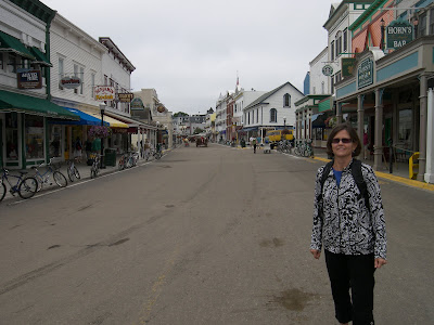
This morning we took an early ferry for the short ride over to Mackinac Island. This small island, pronounced “Mackinaw”, was our nation’s second National Park after Yellowstone but was transferred to state control in 1895. As we cruised closer I was surprised that a state historic park would have so many sailboats in the harbor and large Victorian mansions lining the harbor. At the turn of the century, Mackinac was a hotspot for wealthy Michiganders and apparently it still is. I later learn 20% of the island is still private and another portion is leased from the state to the public.

Aimee and I start off walking around the main downtown section and then up toward the Grand Hotel. I am in awe. I really almost feel I have time-traveled back to the late 19th century. The houses are all beautiful old Victorians and everyone travels either on foot, bike or horse. Cars have been banned on the island ever since the first one scared a horse 105 years ago. We realize this is a sanitized version. We know in the old days, pooper-scooper patrols weren’t following all the horses, there were no electric carts on the golf course, and gardeners weren’t landscaping with gas trimmers. Still we enjoy the experience.

From the Grand Hotel we walk back downtown and tour Fort Mackinaw sitting on a limestone bluff above the town. As forts go, it was well done. This week they also had a whole slew of high school-age girl scouts helping out. After George Rogers Clark took Vincennes in the Revolutionary War, the British got scared and moved their operations here from the mainland and built this fort. We got it with the Treaty of Paris that ended the war. Unfortunately the bloody Brits took it back in the first battle of the War of 1812. It was too vital of a hub for the lucrative fir trade.

We spent most of the rest of the day walking around the island, eating too much ice cream, fudge and caramel corn. We talked to a couple sailors and found out all the sailboats here are from Detroit’s version of the Chicago to Mackinaw race. We were lucky to arrive here early and take in the island when it was uncrowded, and the locals had plenty of time to talk. By early afternoon the crowds were fierce and the magic was gone. Mackinac felt more like Main Street in Disneyland. For exercise and to get away from the crowds we finished our visit with a tandem-bike ride the 7.5 miles around the perimeter of the pretty island.

July 18, 2010


July 18, 2010

We had a rainy drive northeast along the shoreline. We passed lots of cute little towns and loads of busy summer homes. Clearly this is a place Michiganders come to vacation. Just north of Petoskey in Bay View we saw a whole community of old Victorians. I guess Michiganders have been coming here a long time. We stop for the day in Mackinaw City on the tip of Michigan’s mitten.

Tuesday, July 20, 2010

July 17, 2010


July 17, 2010

Aimee wanted a Lazy day and I was a little worried about campsite availability over the weekend so we stayed an extra day at Sleeping Bear Dunes National lakeshore. It was very relaxing. We laid on the beach, soaking up the sun and unfortunately exposing parts that hadn’t seen the sun in a long time. How do Arizonans, especially older ones get sun burnt?

Sunday, July 18, 2010

July 16, 2010

July 16, 2010

Today we backtracked south to the Sleeping Bear Dune National Lakeshore Visitor Center where we perused the exhibits and watched the park film. The shoreline here (and all along Lake Michigan) is the remnant of the glaciers bulldozing a channel past here during the last Ice Age. The prevailing winds then pile up deep layers of sand on the hills to form dunes.

Afterwards we drove the nearby seven-mile scenic route up to the top of Sleeping Bear dune. Along the way we got out and stretched our legs on the Cottonwood trail hiking up and down grass-covered dunes. At Sleeping Bear the dune fell away almost vertically several hundred feet down to the Lake. A handful of the younger and more energetic tourists ran down the dune in mere seconds. The return hike back up probably took an hour. The fact that Aimee easily talked me out of doing it is a testament to me getting older or wiser, not sure which.

We are thinking about taking the ferry out to South Manitou Island just offshore and also part of the National Park. Looking at the map I often thought of them as desolate, isolated and never inhabited. The truth is just the opposite. The offshore islands and the coast were actually the first places to be colonized. In olden days waterways were the highways. The coastal islands were a focal point for the timber industry providing fuel for passing steamships and lumber for building towns (e.g. Chicago) and western forts. When ships switched to coal, the local economy died, and was soon replaced with tourism. In fact, the campground we are staying at was the site of Michigan’s first state park.

July 15, 2010

July 15, 2010

It was drizzling when we awoke so we delayed our departure and then took a leisurely drive to the northwest of Michigan. Along the way we stopped to buy some locally grown cherries at a farmers market. Quite tasty! We noticed a steady stream of RVs going north. Now that is not a good sign. When we finally arrived at Sleeping Bear Dunes National Lakeshore our first stop was the campground. Full! Must be all these laid-off autoworkers taking advantage of the vacation. Sensing some urgency we make the drive to the opposite end of this linear park and snag the last level site in the park’s other campground. Knowing we now have a home we sprint over to the Maritime Museum to see a reenactment of a 19th century shipwreck rescue. This early volunteer coast guard unit would use a cannon to fire a rescue line out to a floundering ship and then ferry the sailors one by one back to safety on a rope chair.

Back at the campground we make the short walk to Lake Michigan for a stroll on the beach. What an improvement over Indiana Dunes. The sand is less rocky, there are no steel mills in the distance, and small islands dot the skyline. Alas, the water is ice cold!

Thursday, July 15, 2010

July 14, 2010

July 14, 2010

Happy Birthday! No not to my mom, hers was yesterday. If you said France, you get partial credit since it is Bastille Day. But who really cares? We are in Michigan and this state's favorite son, Gerald Ford, would have been 97 today. Being Michiganners for time being, we help celebrate by visiting his Presidential Museum in downtown Grand Rapids. I must say Jerry is looking good for 97.

We spend a couple hours going thru his museum. Ford was the only unelected president. He was appointed VP in 1973 when Spiro Agnew resigned after getting caught taking kickbacks. A year later Nixon resigned elevating Ford. I never thought much of Ford until today. In his short tenure, he worked hard to reduce government spending, cut government bureaucracy, and deregulate the economy starting with the railroads and airlines. He seems to have started the revolution that Reagan gets credit for. His biggest mistake was pardoning Nixon. It cost him his own term. Allowing crooked politicians to avoid jail time by resigning sends the wrong message. Success in politics too often goes to the silver-tongued devil who can lie with the straightest face. One only needs to look at Illinois politics to see this truth.

July 13, 2010


July 13, 2010

After spending a week with each of our parents it is time to hit the road again. We don’t make it too far. We stop just over the border at Indiana Dunes National Lakeshore. The National Park owns a patchwork of swampland and lakeshore along twenty miles of Lake Michigan. In between are dotted large steel mills and houses. Indiana Dunes State Park was our first choice but we find their campground books up months in advance. That is probably because it is accessible from Chicago’s South Shore commuter rail line. We fall back to the National Park campground a mile from the lake. After getting a spot, we drive down to the beach and find the one and only spot we can squeeze the RV into. I sit in the sand and have a beer to unwind after fighting Chicago traffic. We then take a stroll along the dune-lined beach. It is far from the prettiest we have walked and near the water, the sand is replaced with gravel that is hard on my tender toes, but it has one big advantage over those beautiful white sand Florida beaches. No ugly Tarballs washing ashore!

Monday, July 12, 2010

July 3-5, 2010

July 3-5, 2010

We are in Godfrey, IL to not only celebrate our country’s birthday but also my mother’s. She will be 90 years old next week. My dad turned 90 six months ago. My aches and pains make me doubt I inherited their longevity genes.

The Monday after the holiday my baby sister and I thought it would be safe to venture into St. Louis and visit the city’s major monument, the Gateway Arch. We were wrong; the crowds were in force. After waiting in a security line to get in the lobby, another line to buy tickets, another for the bathroom, a fourth line to wait in line and then another two lines for good measure, we crammed ourselves into a tiny barrel-shaped elevator for the four minute ride to the top of the hollow arch. Thankfully I was the biggest one of the five in our car. Interestingly after waiting in line for a few hours to get there, we only spent a few minutes looking out the windows. Go figure!

The monument’s official name is the Jefferson National Expansion Memorial and was built as a tribute to St Louis’ place in history as the Gateway to the West. We watched a movie about Lewis and Clark, the most famous group to use St. Louis as their disembarkation point. It was surprisingly outstanding!
Newer Posts Older Posts