Monday, November 27, 2006

November 25, 2006


November 25, 2006

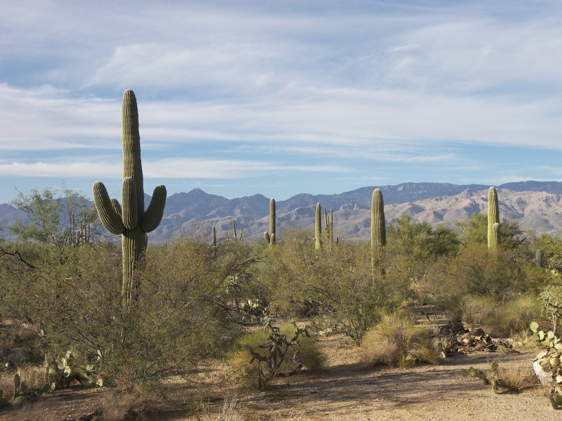
We don’t want the weekend rush of golfers slowing down our golf game so we have decided to do one-day road trips every Saturday instead. We chose to start close to home by making the short drive to nearby Saguaro National Park. One of the reasons I like Tucson (besides the great winter weather) is the abundance of Saguaro cacti that grow up the slopes of the mountain foothills in this area. These green giants are beautiful and majestic. Even though they are the symbol of the whole desert southwest, they only grow in the Sonoran desert that stretches south from Tucson. We first walk thru the visitor’s center of Saguaro East. (The other half of the park is 30 miles away on the other side of Tucson and will have to wait for another day.) The visitor’s center is pretty poor with almost no information on the Saguaro itself. Fortunately, the National Park Service brochure we get later has some tidbits. From the park office, we do the eight-mile loop driving tour. Despite being a desert the terrain is covered with vegetation, including mesquite trees, creosote bushes, prickly pear cacti, and of course saguaro. A hundred years ago, this area was literally forested with saguaro. Since then a couple killer frosts hit the area and the saguaros are fewer and farther between. The saguaro is making a comeback but they grow so slowly it takes about 75 years before young saguaros first sprout their famous branches or side-arms.

Halfway along the loop drive, we stop to make an easy one-hour circular hike thru the cacti. By the time we finish, the sun is starting to set and the temperature is dropping. On the drive out of the park, I catch a great shot of the sun setting next to a saguaro.

Friday, November 17, 2006

November 16, 2006


November 16, 2006

We hope to restart blogging in the spring. Send us an email at mgroshans@gmail.com with ‘blog’ in the title if you would like to be notified when it happens. In the interim, you may see an occasional day trip in the blog.

We rented a three-bedroom apartment today with a pool and great view of the Catalina Mountains north of Tucson. It has a guest room so feel free to visit over the winter.

Thanks to all our faithful readers.

Wednesday, November 15, 2006

November 11, 2006


November 11, 2006

I want to make the cut on the Senior Tour in the spring so we are going to forgo traveling for a while in favor of honing my golf swing. I started this morning and apparently I will need months of practice.

While I was away, Aimee locked herself out of the house. Fortunately for her an RV service center is next door and they helped her with their set of master keys. I am not sure I like the fact that there are a lot of people running around with these master keys. On the bright side Aimee will finally stop bringing up how I locked myself out when we started this Big Adventure.

November 10, 2006


November 10, 2006

Today will be the end of Chapter 4 of our Adventure. It takes us less than an hour to drive west to Tucson. We pull into a campground that we just picked out of our RV camping directory. As we pull in the park entrance, Aimee and I both think we hit RV heaven. We see RV’s everywhere. The complex has a large RV sales lot, a Camping World store, and an RV service facility. We drive past these and into the RV “resort”, not just a mere RV campground. Each RV site has wrought-iron patio furniture and an orange tree. A lot of the sites even have a Jacuzzi alongside. I am feeling a few pangs of guilt as I drink my vodka tonic and read the rest of my novel on our patio under the warm sun while I think of friends back at work in cold Chicago. But then I think of the absolutely huge number of people who do this same ‘snow birding’ all across the south from Arizona to Texas to Florida.

Monday, November 13, 2006

November 8-9, 2006


November 8-9, 2006

In the morning we continue our journey west on I10 for some three hours. We stop at a nice campground in the town of Benson, AZ. The weather is beautiful so we sit in the sun and enjoy it.

The next day after breakfast, we drive the 25 miles south to Tombstone, AZ. The town of Tombstone sprang from the desert in 1870 after silver was found in a nearby mountain. Tombstone was a lawless town notorious for the gunfight at OK Corral between Wyatt Earp and Doc Holliday against some bad guys. We first stop at the old courthouse which is now a state historic site containing a museum on Tombstone’ history. We don’t feel like going thru a museum so we walk down the small town’s Old West main street. The storefronts are mostly western wear shops with a few novelty mini-museums. We eat a lunch of chili and margaritas while watching a lame bunch of actors performing a few of Tombstone’s many shootings. You are supposed to stick around for the 2pm reenactment of the OK Corral shootout but we return to Benson instead and sit by the pool. We could have passed on Tombstone and not missed much.

Friday, November 10, 2006

November 7, 2006

November 7, 2006

This morning we took a day trip with the car to the White Sands Monument. It is 45 miles northeast of Las Cruces in the Tullarosa Basin. The Monument is in the middle of the White Sands Missile Test Range. When we get there we are notified that the Monument will close in about ninety minutes for a test firing. We speed through the driving tour. The Monument is the largest gypsum sand dunes in the world. It is an amazing place. The white shifting sand dunes are everywhere including the road. If it weren’t for the hot weather I would swear we were in Colorado after a snowstorm. I make a snow angel atop a dune for Aimee. Later we see a group of college students sledding down a hill. White Sands formed in the Tullarosa Basin because there are no outgoing rivers to carry away mineral buildup. Rainwater dissolves Gypsum (Calcium Sulfate for my chemist friends) from the surrounding mountains and pools in the Basin area. As the pools evaporate, they leave behind the white gypsum sand crystals.

At 11:30 the park police makes everybody leave the dunes area cutting our visit short. On the way out we stop at the visitor’s center and browse the exhibits. Thinking we beat the park closing we return to our car and head back to Las Cruces. Right outside the visitor’s center we find the road back is also closed for the test firing. Less than ten minutes later we see a corkscrew contrail in the sky. It must be the missile as the police open up the road shortly after. On the drive back we stop at the Missile Museum in the White Sands Test Center. They have a bunch of missiles displayed outside. It is mostly uninteresting but I am amazed at the huge variety of missiles we have developed over the last sixty years.

November 5-6, 2006


November 5-6, 2006

Yesterday evening we met some folks from Denver in the process of buying a second house in town. They convinced us to spend a couple days here checking out the real estate situation. Besides we are no longer chasing the sun, we finally caught up to it. So we decide to slow down and take it easy.

In the morning we head to the Las Cruces annual Renaissance Arte Faire. It turns out to be a cross between a craft fair and a medieval costume party. There are a lot of people into these reenactments. I think some of the guys are just looking for an excuse to carry swords around in public.

In the afternoon we check out some of the local real estate open houses and construction models. There is a lot of new construction in the area and you can get a lot of house for your money here.

The next day we drive over to the New Mexico State University golf course and walk on. The weather is great but not our play. It has been a long time since we swung a club and it shows. We play with a couple early retirees that also think Las Cruces is the place to live.

Afterwards we head to nearby Old Mesilla, the original Spanish village in the area. It is now the home of upscale craft shops and restaurants. That night we celebrate our neighbors’ successful second home offer acceptance at an Old Mesilla Mexican Cantina. The food is great and cheap.

Monday, November 06, 2006

November 4, 2006


November 4, 2006

After waking, we continue our drive west towards El Paso. To get some exercise we stop along the way at Guadalupe National Park to do a morning hike. The Guadalupe Mountains are the limestone remnants of an ocean reef that was formed here 260 million years ago. After stopping at the Visitor’s Center to get oriented, we opt for the 4 mile hike to Devils Hall. The trail first crosses a rocky desert ridge and then descends into a dry wash. Once in the wash, we are shocked to see bright red sugar maples trees mixed in with the cactus and pine trees. The colors are gorgeous. I had no idea the southwest also experienced autumn colors. The trail continues up the wash until the canyon walls converge into a narrow gorge of layered rocks. On the way out the trail becomes packed with Texans wanting to see the colors. This national park is fairly remote and I thought little known. I am surprised to see how crowded it is here.

After our hike, we eat lunch and continue driving another couple hours. West of the Guadalupe Mountains, the terrain is white sandy desert, just what you would expect of an ocean floor near a reef. We stop for the night at a campground in Las Cruces, NM. The weather is finally in the 80’s and I get my sandals and t-shirt out.

Saturday, November 04, 2006

November 3, 2006

November 3, 2006

Today our first stop is downtown Roswell to see the UFO Museum. It is a small museum devoted to the “Roswell Incident”. According to the museum on July 4, 1947 a UFO crash-landed on a ranch near Roswell and the army conspired to keep the story hidden.

After a quick run-thru we drive over to the Roswell Museum and Art Center to see the Goddard exhibit. Unfortunately the Goddard Room is closed for the filming of some TV interview. Robert Goddard was an early pioneer in the development of rockets. In 1930 Goddard moved his laboratory and rocket testing to Roswell because of its open spaces and sparse population. Hoping that the filming would wrap up shortly, we wander around the rest of the Museum to kill time. The museum has some interesting timelines on Indian history and New Mexico history that I find interesting.

Getting impatient, we give up on Goddard and head south out of town towards the Carlsbad Caverns. Along the way the terrain turns from flat ranchlands into desert. When we turn west into the Park we climb into some rocky desert hills. At the national park we choose to hike into the cavern through the natural route. The cave entrance looks just like the jigsaw puzzle my family had of it when I was a kid. This historical entrance is a huge hole in the ground. The park service has constructed a 1.25-mile paved path that takes you steeply down into the main cavern 800 feet below the surface. Once there we hike the 1.25-mile path around the “Big Room”. The cave is huge and long, decorated extensively with Calcite stalagmites and stalactites of all sizes. In summer, people sit at the natural entrance every evening to watch a cloud of thousands of bats fly out of this “bat cave” in search of insects. Finished with our self-guided tour of the main cave, we ride the elevator back to the Park Visitor’s Center and spend the night at a rustic RV campground outside the Park.

November 2, 2006

November 2, 2006 This morning we drove south to Canyon, TX for a quick visit to the Panhandle Plains Museum on the campus of West Texas State University. The museum has a few exhibits on what seems like almost everything including oil drilling, fossils, old cars, windmills and art. Despite the wide diversity, it works well. The museum also had an outstanding mineral exhibit on loan from Houston that had some very fine specimens. From Canyon we take the back roads southwest across the Llano Estacado, the southern high plains. This area was part of what was known as the Great American Desert until they got the bright idea of using windmills to pump water from underground aquifers. We see the result on the drive from Canyon; we pass one giant cattle feedlot after another. I have never seen so many cows in one place. We also see fields of cotton; it is pretty to see the fields of white puffs. The cotton must be close to pickin’ as white lint is lining the edge of the road. You can tell that drought is around the corner if the water pumps fail as we see tumbleweeds crossing the highway and collecting against the fencing. After four hours we cross the Pecos River and stop at a private campground in Roswell, NM.

November 1, 2006

November 1, 2006

Amarillo is the home of Aimee’s sister and her family. Her sister came here for college and never left. We stopped by their house for dinner when we arrived yesterday evening and caught up on family news.

In the morning we drove south with the car to Palo Duro Canyon State Park. Palo Duro is supposed to be the second deepest canyon in the US next to the Grand Canyon. We take a quick tour of the Interpretative Center and then drive the six-mile loop thru the canyon. Amazingly just a tiny stream carved this deep canyon albeit over millions of years. On the drive we also see turkeys and mule deer.

In the afternoon we head northwest with the family to Cal Farley’s Boys Ranch where our brother-in-law works. He gives us a tour of this city-size orphanage. Since many of the children are troubled and come from broken homes, this impressive facility employs many counselors who use innovative techniques. The highlight of the tour is watching a group session using horses. The teenagers are assigned a task of getting this horse to walk an obstacle course without touching the horse. Little do these kids realize that instead of learning about horses, they are learning to be friends, and how to work together to solve problems. Pretty cool. Seeing the facilities they have, I would have liked to grow up here. On the way back to Amarillo we have the family over to our house for a tour.

Thursday, November 02, 2006

October 31, 2006

October 31, 2006

It is very chilly this morning. The cold front hit early, and the intense wind is driving the chill factor below zero. I think the bad weather is following us everywhere we go.

We drop the RV off at a local Wal-Mart parking lot and take the car into Oklahoma City to visit the National Cowboy Museum. The museum is very large, and we spend a couple hours walking thru it, but both Aimee and I don’t find it all that interesting. The museum does have some western art galleries that I do find nice. I have always liked Frederick Remington’s western sculptures and I also wouldn’t mind having a few of the western paintings in our future house.

On the way back to pick up the RV, we take a detour thru the downtown area and the site of the Alfred P. Murrah federal building that was blown up in 1995 by a truck bomb. The building remnant was razed and replaced with Oklahoma City National Memorial. The memorial is nicely designed. It is interesting to see the site map now vs. before. They have replaced an adjoining road with a shallow reflecting pool. The small building footprint is now a garden with a chair for every victim. The chairs are situated approximately where they were killed with each row representing a floor. Nineteen of the chairs are child-size. And all this carnage was perpetrated by an American.

From OK City we head west again. A half hour along we finally find the flat Kansas-like prairie I was expecting. Once across the border into the Texas Panhandle, the terrain is flat as a pancake. We stop at a rest area in Texas to stretch our legs. The rest stop has an interesting mini-museum on the Panhandle’s history. In particular we learn that this area is one of the windiest in the country (I can vouch for that) and already has a number of windfarms generating electricity. Déjà vu! I guess I wasn’t the first with this suggestion. Just before 6pm, we stop at a campground in Amarillo, TX.

Wednesday, November 01, 2006

October 30, 2006

October 30, 2006

Fortunately for our slumber, the trains last night stopped blowing their horns near midnight and didn’t restart till 9:30 this morning. By that time we were up and ready to depart.

Even though Aimee picked the campground, it turns out to be only a couple miles from the Civil War Battle site, Wilson Creek. Because of its proximity Aimee lets me stop for a quick look. Missouri, a slave state, was divided in sentiment. I had always thought that the border slave states of Missouri, Kentucky and Maryland had voluntarily stayed in the Union. Actually the Federal government helped them make that decision. When we were in Baltimore, we learned that Lincoln had put the Maryland Legislature in jail at Fort McHenry so they couldn’t vote for secession. In Missouri, pro-slavery forces lead by the governor setup a government in exile and voted to secede from the Union. The pro-Union forces then were able to run the Missouri government without opposition. Early in the war, southwestern Confederate forces linked up and began marching north to retake Missouri. An outnumbered Union force, lead by Nathaniel Lyon, was tasked to disrupt their operation, until reinforcements could be gathered. He attacked the Confederate forces southwest of Springfield in August 1861. Although the Union forces ultimately retreated they were successful in delaying the Confederate advance.

Aimee lets me watch the park movie and the battle light show but we pass on the five-mile driving tour of the park. Unlike at other battlefields we have visited, Nathaniel Lyon was an experienced Union commander and did a great job conducting this battle. Unfortunately for the Union cause, he died during the course of the engagement.

From Springfield, I was hoping to make a stop in Branson for a music show but the weatherman is forecasting the return of a cold front so we punt and continue our journey to warmer climes. We get back on I44 heading towards Tulsa, OK. The RV is relatively easy to drive unless the wind is blowing and today it is a sideways gale force. I am struggling to keep the RV on the highway. So much for a relaxing drive. All I can think about is how we need to harness this relentless energy with windmills in these prairie states.

Needing a break in the middle of the drive, we stop at the Will Rogers Museum in Claremore, OK. Neither Aimee nor I knew much about Will Rogers beforehand. The museum is a memorial to his life. Rogers was born here in 1879 and started his career doing rope tricks in traveling Wild West shows. He graduated to performing in vaudeville shows on Broadway, then countless movies in Hollywood. He became noted and beloved by this country for his “common man” humorist role when he added a radio show and a weekly newspaper column. An inveterate traveler, he died prematurely in 1935 in a bush plane crash in Alaska.

After this interesting stop we continue our journey west and stay the evening in Oklahoma City. The whole journey thru Oklahoma I was expecting to see desolate prairie like Kansas. Instead so far Oklahoma has been a pretty, gently rolling, heavily forested countryside with almost no farms to be seen.

October 29, 2006


October 29, 2006

The weather has finally broken. It looks like it will be a beautiful day. We load up the RV and head southwest around 11am. This trip we are caravanning with two vehicles, the RV and our car. Driving across country is not as much fun without my trusty navigator alongside me. Aimee is equally disappointed that she can’t give me her periodic helpful driving advice. To maintain some contact with each other we bought a pair of two-way radios a few days ago. Aided by an extra hour with the Daylight Savings time change, we drive more than four hours to Springfield, MO.

Southern Missouri is a scenic, hilly, forested region, especially in the fall when the trees have all turned vivid colors of red and gold. We stay at a nice KOA we later find is near train tracks. Aimee feels like she is back home in Itasca as trains roll by almost every half hour tooting their horns.
Newer Posts Older Posts