Monday, September 29, 2008

September 24, 2008


September 24, 2008

Aimee and I are both glad to be back in Tucson. It has been a long summer in the RV (124 nights!), longer than optimum. We need an extended break. The other reason we are anxious to get out of the RV is that we luckily snagged the best apartment in Tucson. It is in the same complex as last year but has the best view. To keep it we may have to rent it year round. That is ok, real estate and the economy seem to be worse than ever, at least if you are a Wall Street Investment banker, so buying a house may still need to wait.

This summer we drove well over 16000 miles, had great gas mileage of nearly 11.5 mpg, but paid the highest gas prices ever averaging almost $4/gallon. Ouch! With all this time on the road, we have now visited 180 National Parks, Monument, and Historical Sites. Only 210 left to go. In addition we hit a bunch of Canadian National Parks and US state parks. I am more than ready to be a sedentary vegetable for a while, sorting thru thousands of photos, but we already have plans to visit southern California this winter and maybe Alaska next summer. In the meantime the SS Free at Last needs some expensive work. After all that shaking on Canadian Maritime roads, the RV is starting to actually fall apart. Can’t let that happen.

Tuesday, September 23, 2008

September 21, 2008


September 21, 2008

From the Mogollon Rim area we drove south down out of the pine-forested mountains thru desert hills eventually coming to Roosevelt Lake Recreation area. This dammed up river is an oasis in the desert east of Phoenix. Along the shore we stop at Tonto National Monument. Hoping to see the Lone Ranger, Aimee is disappointed to find it is another ancient Indian ruin. This one is sort of a bust. The Visitor Center movie is out of order, and the ruins are closed because of a Killer Bee infestation. Nonetheless, we take the very short hike uphill to admire the ruins, from afar, set in a notch surrounded by Giant Saguaro cacti.

From Tonto we finish the long drive to Tucson, ending our 3rd summer of travel.

September 20, 2008


September 20, 2008

From Canyon de Chelly, we head south stopping briefly at Hubbell Trading Post Historical Site. I am glad it was not out of our way. Aimee and I weren’t impressed. On the site sits a trading post from 1876 that Lorenzo Hubbell built to barter with the new Navajo Reservation. Hubbell exchanged handmade Indian crafts for necessities the Navajo needed. The Visitor Center has no exhibits, only a short blurb about the trading post on a Canyon de Chelly film. The trading post still survives and is now home to a gift shop selling Navajo crafts.

From the trading post we head southwest thru arid scrubland eventually running into pine forest.country. We stopped at the Mogollan Rim Visitor Center but it was closed for renovation. Undeterred we got a few shots from the rim overlooking the forest below. I believe the Mogollan Rim is the southern edge of the Colorado Plateau. In the parking lot we got a recommendation to stay at a campground five miles away off the highway near Woods Lake Canyon. It was a great choice. Despite being in Arizona only an hour from very hot Phoenix, we are in the middle of a pleasantly cool, pine forest.

September 19, 2008


September 19, 2008

From the campground of Canyon de Chelly National Monument, we started at the Visitor Center and watched a very boring movie that talked about nothing. We then looked at the exhibits that told of the five Indian groups that lived in the canyon thru history. Disappointingly there is almost no information about the last residents, the Navajos, that continue to live here. I was looking forward to learning about Navajo history here after seeing a snippet of a PBS show last winter about the Navajo War. Canyon de Chelly starred during the war as the Navajo’s last stronghold. What I did learn was the Navajos (and Apaches) migrated to this region in the 1700’s from western Canada pushing the local Pueblo and Hopi Indians out of the way.

Canyon de Chelly is a delta-shaped set of canyons in this otherwise flat terrain. In the morning we drive the length of the north rim stopping at the overlooks. Canyon de Chelly is a canyon system of sheer red cliffs enclosing a green verdant valley. Very pretty! At most of the overlooks you can spot an ancient Anasazi cliff dwelling on the opposite wall. There are also several Navajo vendors at every overlook selling jewelry. In the afternoon we drive the south rim. Along the way we take a break from the driving tour for a two hour hike down into the canyon to see the Anasazi ruin, “the White House”. This is the only hike that can be done solo. All other hikes into the canyon require hiring a Navajo guide. I am very cynical about these kinds of requirements, but in this case, I don’t complain too much. On the plus side the campground is free, courtesy of the Navajos. After the hike we continue on to each overlook, finishing with the best and why I came here, Spider Rock. This last vista is worth the trip. It is stunning. Having lazily spent the day investigating Canyon de Chelly, we return to the park’s campground for another free stay.

September 18, 2008


September 18, 2008

It is a little too late in the season for us to be staying at 9000-foot elevation with a thinly insulated house. Nighttime temps drop uncomfortably below freezing here. So from the Kaibab Plateau, we retrace our path and head back downhill towards Page, AZ. After crossing the Colorado River we continue east across the center of the Navajo Nation Reservation, the largest in the US at 27,000 square miles and occupying most of northeastern Arizona. Right in the center of the Navajo Nation is the Hopi Reservation. Traveling this route can be hard on the watch as the Navajos follow Daylight Savings time while the Hopis and the rest of Arizona do not.

Our travel thru this very desolate land of mesas and dry grasslands is only interrupted with a brief stop to see some roadside Dinosaur footprints. A hand painted sign is our only heads-up. There a couple Indian kids give us the dime tour for a small tip. This flat rock expanse is full of footprints, coprolites (dino poo), and deteriorated skeletons everywhere you look.

After driving all day we arrive at Canyon de Chelly National Monument and stay at the park’s campground. We are ecstatic to find it is wide open. When Aimee had called earlier in the day she was told it was booked. I was afraid we were going to have to spend the night in some parking lot. Fortunately Aimee felt lucky and we came anyway. After dinner we attended a campground ranger talk to watch a local Navajo woman decorate a beautiful clay pot.

September 17, 2008


September 17, 2008

On our way out of Page, AZ we stopped at Horseshoe Bend Lookout. A half-mile hike from the road gives us a spectacular view of an almost full circle meander of the Colorado River. It is similar to the Goosenecks of the San Juan, but larger and more colorful.

Continuing west, we cross the Colorado over the Navajo Bridge and follow the Vermillion Cliffs west. After a while we climb the canyon wall and continue up the 9000-foot Kaibab Plateau into a pine forest. A left turn will take us into the North Rim of the Grand Canyon. Before heading into the park, we take a detour to see Pipe Spring National Monument. Pipe Spring is the site of a water spring that local Paiute Indians used and later by Mormon Pioneers who built a fort around it. The surrounding ranch was initially run by the Mormon Church to generate revenue for Temple construction. Pipe Spring later became a haven for Mormon polygamists escaping prosecution in Utah. As a National Monument, it is in my opinion historically weak and insignificant and probably not well visited. Despite that fact we counted ten park rangers. While we were there four of the women rangers were having an extended discussion about clearing brush away from the sidewalk. These four spent at least an hour deciding how many inches should be cleared from each side without a single weed being removed. I couldn’t help laughing. This is government bureaucracy at its best.

Back atop the Kaibab Plateau, we head to the North Rim of Grand Canyon National Park. I am a little miffed at the park service on the way in. They have tens of thousands of acres of forestland north of the canyon but can only manage to clear room for 83 campers, maybe a busload or two of visitors. The park service complains of low visitation at the north rim but can’t seem to accommodate more than a handful. Unfortunately for visitors it is a long drive to and from the North Rim. It is getting late in the afternoon and I am trying to decide whether to go in now or wait till tomorrow. We decide to head in anyway and see what we can. I am glad we did. The North Rim is not as spectacular as the south. Because the terrain slopes south here, the North Rim is heavily eroded while the south is more of a sheer drop-off. Instead of wide expansive overlooks, the north has only a few at the far end of long jettys. In fact the main viewing spot seems pretty crowded with just the half dozen people that were with us. The north rim is not designed for big crowds. Maybe in the NPS’s infinite wisdom the paucity of accommodations is their way of keeping visitation to a manageable level.

We are running out of daylight so we head out of the park and stay at the closest open campground, one in the Kaibab National Forest, some 30 miles from the rim. Much to my dismay, it starts to rain when we get there. But as they say, there is a pot of gold at the end of every rainbow. In this case my pot was a full 180-degree rainbow, the first I have caught on film.

September 16, 2008


September 16, 2008

Page, AZ is the primary doorway to Glen Canyon National Recreation Area. This morning we signed up for a Rainbow Bridge Cruise. Rainbow Bridge National Monument is the destination but for us just an excuse to take a cruise on Lake Powell. We spent a week on a houseboat many years ago on the upper stretches of Lake Powell and loved it. This cruise will give us a chance to relive some of those memories and see how the lower canyon compares. On our way to the boat dock we make a brief stop at the Glen Canyon Dam. Completed in the 60’s across the Colorado River upstream from the Grand Canyon, this dam holds back the huge Lake Powell. It is fifty miles to Rainbow Bridge, but it goes by quickly. The scenery is otherworldly. So much so it starred as the alien planet in the original ”Planet of the Apes” movie. Like a water-filled Grand Canyon, Lake Powell consists of dark blue water, with high sheer red cliffs set against a beautiful blue sky. It is mesmerizing. After two hours we turn into a narrow arm off the main channel and dock about a mile up. From there it is a short hike to Rainbow Bridge. This rock bridge is the Gateway Arch of the West. It is huge and almost perfectly parabola-shaped. The return trip is no less enchanting. With the setting sun the cliff colors seem to come alive. Back late, we spend another night in Page, AZ.

Tuesday, September 16, 2008

September 15, 2008


September 15, 2008

From Navajo National Monument we drove northwest towards Page, AZ. Just outside Page, we stopped at the Antelope Canyon Tribal Park. We are still on the Navajo Nation Reservation. Antelope Canyon only got on my must see list last winter when I saw photos of it at a Tucson craft fair. I had seen photos and read about slot canyons but always thought they were hard to find. Unfortunately it seems Antelope Canyon is no secret. There are plenty of tourists waiting to see this small site. Like Monument Valley, this tribal park smells of disorganization. After paying a fee to earn the right to pay for a mandatory, guided tour, I sign Aimee up for a standard tour and myself for a longer photographic tour. Twelve of us are driven in an open four-wheel drive truck down a wide sandy gully to a dead-end wall with a narrow crack in it. A dozen trucks are already parked outside it. This is going to be a zoo; there is no way I am going to get any good photos. The canyon is pretty cool. The walls are narrow and eroded to a weirdly smooth texture. It is also dark with only narrow shafts of light illuminating the floor, at noon! Despite the crowds in this very small area, it seems to be organized chaos and I end up getting some good photos. It takes a while though. The initial chaos made finding the right camera settings for these long exposure shots difficult.

From Antelope Canyon we drive into Page, AZ and spend the night at a private RV park.

September 14, 2008


September 14, 2008

Yesterday we signed up for a guided tour to see the Betatakin ruins at Navajo National Monument. We meet our guide, a young Navajo woman, at the Visitor Center, and then drove as a group to the trailhead. From there it is a two-hour hike down the canyon to the overhang ruins. It is only a couple miles but we stop often waiting for this out-of-shape woman to catch up with the group. Our Navajo guide also tells us lots of stories of Navajo traditions and plant medicines along the way. More than I really have an interest in. Fortunately the canyon is gorgeous and I spend the time looking at the scenery and snapping photos.

Once at the ruins we have a chance to walk amongst the stone houses nestled under this immense overhang. If I were an ancient Indian, this would have been where I lived too. The view is awesome. We are on our own for the return trip. Even though the hike out is uphill, in the heat, and we stop for lunch, we make it out much quicker.

We finished the hike tired, and we like the local campsite, so we spend the night here again at Navajo National Monument. We have a long conversation with a Dutch couple camping around the corner. We have traveled more than most Americans, but this Dutch couple has been everywhere we have and then some! The majority of travelers we are running into now are Europeans. On the drive here from Monument Valley yesterday, rental RV’s passed us going the opposite direction almost every minute, with no exaggeration! And it is Europeans, almost exclusively, who drive those rentals. I am praying for a weak Euro so I can soon repay the favor.

September 13, 2008


September 13, 2008

I woke early this morning to get a dawn shot of the Goosenecks of the San Juan, but the canyon is so deep the sunshine doesn’t penetrate till hours later. When the sun rose higher and lit the canyon better, it washed out the colors. I guess I need a cloudy day for the best shot here. Unfortunately those are rare in this region.

Leaving Goosenecks we drive southwest to Monument Valley Tribal Park. I have wanted to come here forever. Monument Valley, on the Navajo Reservation, was THE classic set for Western movies. It is so recognizable, being dotted with distinctive red buttes. I would love to know the geology of why they are in the middle of nowhere, but I am not going to find out here. This is a tribal park and not a National Park. Organization doesn’t seem to be the tribal strongpoint. The park looks like it just opened for business. I am sure there is plenty of tribal in-fighting between keeping the park primitive and those wanting to exploit the resource. There is a 17-mile scenic dirt road you can drive around the valley. That is way too long for our rattletrap motorhome and I hate those inflexible guided tours. So we opt for a great shot from the visitor center and then a 3-mile hike around one of the buttes. We have already decided we need to return pulling a jeep to better explore many of these more remote, but very cool sites in Utah and Arizona.

From Monument Valley we drive southwest into Arizona and visit Navajo National Monument. This is another cliff-dwelling site of the ancient Anasazi Indians. After the obligatory film we take a short hike to an overlook of the main ruin. It is a small village built under a huge overhang in the cliff. It is late in the day so we find a spot in the park's campground. We are surprised at how nice (and free) it is.

September 12, 2008


September 12, 2008

From Blanding, UT we drove west thru Utah’s canyon country. A stark but beautiful landscape. In less than an hour we arrive at Natural Bridges National Monument, the first National Park unit set aside in Utah. It is a hidden gem, crowded out of the spotlight by southern Utah’s now burgeoning list of National Parks. Natural Bridges is home to three of America’s largest stone bridges. Bridges are the river-formed cousins of Arches. We are in the middle of the high Colorado Plateau. Millions of years ago lazy rivers meandered across this landscape. When the Colorado Plateau was uplifted by tectonic forces, these rivers cut thru the rock with the force of gravity. The meanders of this local river became locked in the stone of the canyon’s depth. Over time erosion opened shortcuts across three of the meanders leaving only rock spans behind.

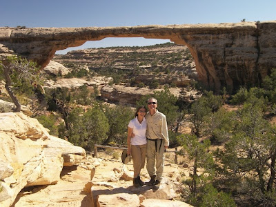
After watching the excellent film at the Visitor Center, we begin the 9-mile driving loop that takes us to each of the bridges. At each one we stop at the overlook and then make the short hike down into the canyon for an up close and personal look. Aimee refuses to stand under any of them; not since she read about the recent crash of Wall Arch in Arches National Park. It is a delightful day of short hikes. The weather is sunny and bright and the scenery simply stunning.

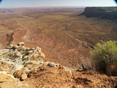
After spending most of the day at Natural Bridges, we head south toward the Arizona border for our final run to Tucson. After some thirty miles, the pavement ends and we make a sudden stop at the top of a sheer cliff seemingly the size of the Grand Canyon. Yes, the dirt road continues, down the cliff wall, via a series of narrow switchbacks. WOW! This is both the coolest and the worst three miles of road we have traveled. This is America’s answer to Bolivia’s famed Death Road. After stopping first to awe at the road ahead, I slowly start down, careful not to brake hard and slide off, but quickly enough before some RV decides to pass me going uphill. The road is not wide enough for two of us. With Aimee’s eyes closed, and thankfully only a few motorcycles going in the opposite direction, we make it to the bottom of the canyon. This turns out only to be the upper canyon.

A few miles down the road we meet up with the San Juan River and the Inner Gorge at Goosenecks State Park. Here we encounter the Granddaddy of entrenched meanders. At this small spot the San Juan River switchbacks three times at the bottom of a deep canyon. Simply Awesome. Unfortunately, the sun is right in our eyes and my photos are terrible. We are going to have to stay till sunrise. But there is no campground here, only a large unpaved parking lot. To Aimee’s dismay, I park the RV on the canyon lip and setup camp.

September 11, 2008


September 11, 2008

From the Mesa Verde area in southwestern Colorado, we drove west via back roads to the remote site of Hovenweep National Monument. Apparently it is not remote enough or there are plenty of nuts like me, because the parking lot is full. Hovenweep is one of many ancient Anasazi Indians ruins scattered around the Southwest. This one consists of several communities that built stone buildings atop the rims of local canyons. Aimee and I take a 2-mile hike around one of the canyons. There are only a handful of stone ruins left but it is clear they were defensive in nature, probably protecting the trickle of life-sustaining water in the canyon. The question is who were they afraid of? Themselves? Like elsewhere, the Anasazi villages were all abandoned around 1300 AD. I guess eventually the water dried up so much it wasn’t worth protecting anymore. One of the rim ruins we passed was called Twin Towers. It reminds us that today is 9-11 and makes us think about where we were on this day seven years ago.

From Hovenweep, we work our way northwest to Blanding, UT, where we visit the town’s Dinosaur Museum. Although small it is very nice, concentrating on only a few topics. One section is about dinosaur footprints. I was surprised to learn that dinosaur track fossils are very common and provide lots of information on dinosaur social behavior. They have found thousands between Denver and Texas, the site of an ancient seashore. So many that they think it used to be a dino migration route. Another section of the museum is on feathered dinosaurs and the evolution of birds from reptile ancestors. The last and most amusing is dinosaurs in film. That section brought back a lot of memories. We spend the night at an RV park two blocks away. Now that is convenient.

Wednesday, September 10, 2008

September 10, 2008


September 10, 2008

We got up early this morning to hike up onto the dune field of Great Sand Dune National Park. It rained some last night and that should make the climb easier. Climbing wet sand is much easier than dry. Plus I want to get up there early before other hikers make tracks on the smooth sand. After a lot of work we make it up to the top of one of the peaks. It is far from the highest. Getting to the tallest peaks would mean going downhill and uphill again and we are not ready for that much exercise. Plus we are freezing. We should have dressed warmer. It is chilly, and the fierce wind at the top is numbing. On the trip down it starts spitting rain and right after we get back in the RV it starts to pour.

We are determined to find warm dry weather! So we keep journeying west. The rumor of a drought in the West so far is baloney. We cross to the west side of this wide agricultural San Luis valley and head up into the mountains. We join up with the Rio Grande River and climb the South Fork through a beautiful canyon. We cross a high mountain pass and descend down the San Juan River canyon. Also very pretty. From there we drive west past Durango and spend the evening at an RV park outside Mesa Verde National Park.

Tuesday, September 09, 2008

September 9, 2008


September 9, 2008

From Buena Vista, CO we drove south along the Arkansas River Valley over a pass and into another wide, flat, dry high-country valley. When I think of western Colorado, I think mountains and don’t realize that Colorado has this many valleys. Eventually we turn east and I can see Great Sand Dunes National Park in the distance. At first I thought they were just oddly colored foothills of the mountain range, but they are actually mountain-sized sand dunes. This is probably one of the few National Parks that can be seen from miles away. What an oddity this park is. To have a mountain of sand next to a mountain range. You would think we were in the Sahara.

Our first stop in the park is the Visitor Center. There we watch a very mediocre film but learn that the sand pile is here because of winds that trap the sand in an elbow of the mountain range. Afterwards we head to the Dunes parking lot for an up close and personal look. Walking in sand is difficult enough when it is flat. This is work. After this brief taste, we pick out a campsite in the park and relax the rest of the day.

September 8, 2008


September 8, 2008

From Parker, CO, we headed south to Colorado Springs. There we revisited the Garden of the Gods. The Garden is a compact, city-park sized version of Arches National Park in Utah (albeit minus the arches). They both have these magnificent red fins formed when the ancient sandstone was uplifted, then tilted sideways, and allowed to erode in sheets. We stop at several spots along the park road and walk amidst the rocks. It is a beautiful spot… if it only wasn’t cold and cloudy!

The weather report said it was warmer and sunnier to the west, so we made a sharp right turn and drove to Florissant Fossil Bed National Monument. What an awesome spot! The first thing we did was hike the one-mile Petrified Trail. Before we went ten yards, we came face to face with a giant petrified tree stump still in the ground. It is an ancient redwood tree. It is the first of ten we see on this short hike. About a 100 more are still buried. We have seen several petrified “forests”, but this is the first that actually looks like a “forest”. And giant redwoods no less! Theory goes that 34 million years ago during the Eocene Epoch, a forest here was flattened by a “lahar” mudflow from an erupting volcano. The hot blast leveled and incinerated everything in its path, but the largest redwoods. The redwood tops rotted away and the stumps were buried by regular ash eruptions. Florissant has some of the largest and smallest of fossils. Besides the redwoods, the volcanic ash also entombed exquisitely preserved insects of all kinds from tarantulas to butterflies. After the hike we listen to a fascinating ranger talk. The rangers often make or break a park. When you have a great ranger, interesting history and neat science, it works and is why we go out of our way to visit National Park sites. More often than not the combo works great.

After the talk, we return to the Visitor Center for the film and a look at the fossil exhibits. Amazingly the park was almost destroyed in the 60’s to make way for a housing development. One buyer who took advantage before LBJ saved it was Walt Disney. He came and bought one of the stumps. Supposedly it adorns Frontierland in Anaheim’s Disneyland. Gotta check that out this winter!

From Florissant we continue west over mountain highlands, thru a very wide and dry valley, over another mountain pass to the Arkansas River valley, where we stay the night at an RV park in Buena Vista, CO.

September 7, 2008


September 7, 2008

From Fort Laramie, WY we follow the old Oregon Trail to Guernsey, WY. Just outside the town are some of the remnants of pioneers passing thru the area. The first site has deep parallel cuts in the rock crests. So many pioneer wagons with their iron rimmed wheels passed over this crest that they gouged deep ruts into the solid rock! The second site, Register Cliff, is next to the North Platte River. Many of the pioneers who camped on this flat grassy spot carved their names on the adjoining sandstone cliff wall. While you can see lots of names from 150 years ago, (if you look hard), there is mostly modern graffiti.

The weather has turned decidedly colder today. That is the snowbird’s clue to head south; so we link up with I-25, bid adieu to the Overland Trails and take the highway south. The route takes us through barren ranchlands. There is not a tree or building to be seen in any direction. We pass by Wyoming’s capital, Cheyenne, cross into Colorado and roll into the Denver suburb of Parker to visit Aimee’s brother and his family. The six of us pile into our covered wagon and drive to nearby Castlewood Canyon State Park. There we do a short hike in the canyon and in honor of our pioneer ancestors have a chuck wagon supper of BBQ-ed hamburgers.

Sunday, September 07, 2008

September 6, 2008


September 6, 2008

Aimee and I are aghast. It rained yet again last night. We have a black cloud that just won’t leave us alone. If we go to Tucson right now, we are liable to turn desert into rain forest.

We have a long day ahead of us, so we rise early and drive the couple miles to Scott’s Bluff National Monument. One of the young park rangers offers to shuttle us up to the top of the ridge. We should have great views of the surroundings there but one side of the ridge is shrouded in fog. We opt to hike back to the Visitor Center. I am glad we do, as it is outstanding. The trail descends down one side of the butte then crosses by tunnel to the other side for the rest of the hike down. Back at the Visitor Center we watch the park film and peruse the exhibits but they are pretty weak on history. The Oregon Trail, the Pony Express and finally the Transcontinental Telegraph line all went right between the two halves of Scott’s Bluff.

From Scott’s Bluff we make a short detour north of the Oregon Trail past barren ranchlands on a sunflower lined highway to visit Agate Fossil National Monument. Here in these eroded ridges, paleontologists have uncovered a treasure trove of Miocene fossils from 19 million years ago. At that time, the grassland here resembled the Serengeti Plains of Africa. A drought occurred at a watering hole causing many of the local inhabitants to perish in the mud. Unearthed were grass-eating Rhinos and carnivorous Beardogs the size of lions. After looking at the Visitor Center exhibits, we take a hike along the Daemonelix trail. This trail is famous for giant spiral formations found in the mudstone. These rock corkscrews are the fossilized burrows of extinct prairie dog-like beavers.

Back on the Oregon Trail, we follow it to Fort Laramie National Historic Site. Fort Laramie at the confluence of the Laramie and North Platte Rivers was the major fort of the west. It was initially built to protect pioneers on the Overland Trails but later became the focal point of the Plains Indian wars. Fort Laramie is a huge complex, the size and look of a modern military base. Many of the barracks and officer quarters have been restored. Superbly I might add. They could easily pass for the set of a western cavalry film. But a little too realistic for me. I would prefer that they had added some modern signage to better explain what we are looking at.

Tired after a long day, we spend the night at an RV park just outside the fort.

Friday, September 05, 2008

September 5, 2008


September 5, 2008

Well the sunflowers are frowning today. The rainy cold weather has caught up to us again. From Mormon Island we cross the smallish Platte River and follow it west through Nebraska. It rains the whole morning. The terrain is flat and full of cornfields reminding me of Illinois. Surprisingly Iowa was the more scenic state. Same cornfields, but with lots of rolling hills.

By afternoon we have outrun the wet weather again. Yeah! At the town of Ogallala, NB we depart I-80 and follow the North Platte River northwest. This is the same route that our country’s early pioneers followed on their journey west. Only they did it walking beside their oxen drawn wagon. After 600 miles of walking they would have come upon the major landmark of the trip, Chimney Rock. This distinctive needle formation can be seen for miles away and marked their one-third point. Only 1200 more miles of walking to go! Chimney Rock is now a National Historic Site. We stop at the visitor center, and watch a very good film about the pioneer trails.

A little further west we stop for the evening at a very nice RV Park in Gering, NB. Our site sits in the shadow of Scott’s Bluff, another famous rock landmark along the pioneer trail.

September 4, 2008


September 4, 2008

It rained all night and we wake to cool rainy weather. The TV weatherman says it is the remnant of Hurricane Gustav that hit Louisiana a few days ago. We spend most of the day driving west trying to outrun the rain. As if on cue, the sun pops out as we cross over the Missouri River into Nebraska. And in celebration, thousands of sunflowers along the side of the highway smile at us.

We continue along I-80 past Omaha and Nebraska’s capital, Lincoln, and spend the night at the Mormon Island Recreation Area. The park is named after the Mormon pioneers who passed by here on their journey west to Utah. They thought they were escaping persecution by settling outside the US. Unfortunately for them, Mexico soon ceded the Utah territory to the US.

September 3, 2008


September 3, 2008

Just west of us in West Branch, IA is the Herbert Hoover National Historic Site. We start our tour with a walk thru the tiny two-room house where Hoover was born and then move on to his Presidential Library and Museum. The exhibits are quite well done and we spend way more time here than I had anticipated. Herbert Hoover, our 31st president, lived in Iowa until he was orphaned at the age of nine. After graduating from Stanford, he made a fortune as a mining engineer when he discovered gold in Australia. During WWI he directed charity relief efforts to feed the starving of Europe, and became internationally famous as the Great Humanitarian. He served as Secretary of Commerce during President Coolidge’s administration and led an unprecedented improvement in the American standard of living. With his help a huge percentage of Americans owned a house, car, telephone, and radio for the first time. He was considered “A Wonder Boy” and won the 1928 presidential election by a landslide. Unfortunately his long string of success ran out. The Great Depression hit with a vengeance a few months later. Bad luck for sure. He inherited a severely overheated economy ripe for the bubble to burst. Although he wisely embarked on an unprecedented federal spending spree, he counteracted the benefit by hiking taxes on the rich and tariffs on imports. His worst sin was probably communications. He failed to instill the nation with hope or take credit for his stimulus projects. By the end of his term he was being vilified by the public, and lost his re-election by a landslide.

A little further west we stop in Iowa City to see the Devonian Fossil Gorge. During the big flood of 1993, surging waters flew over the dam spillway here and exposed limestone rocks containing sea fossils from 370 million years ago. It is hard to imagine that Iowa was once under the ocean. Unfortunately this site is not too tourist friendly right now. The big flood they had this spring wiped out most of the identification markers. Nevertheless we are able to spot a few oyster and crinoid specimens in the rocks.

We spend the night at an RV park an hour west in Kellogg, IA.

Wednesday, September 03, 2008

September 2, 2008

September 2, 2008

We are on the road again, westward ho. We are glad and ready to be heading west toward sunny and drier weather. We liked our trip out to the northeast but we tired of the persistent rain and humid weather. We saw some nice scenery, but nothing that matches the majesty of the West. I guess we have become Westerners at heart now.

From Itasca, IL we drove west to the Iowa border, spending the night in an RV park in Tipton, IA.
Newer Posts Older Posts