Thursday, July 31, 2008

July 30,2008


July 30, 2008

By sheer coincidence, the Freeport campground we stayed at last night was associated with an oddball attraction called the Desert of Maine. The owner lets campers walk the site. We do so after dinner. It turns out to be a real sand desert in the middle of a Maine pine forest. One of the placards explains that the sand appeared because of soil erosion from poor farming practices. I guess that explains why we see few farms in Maine. The topsoil is thin and just barely covers the ground.

In the morning we head west leaving Maine and crossing into New Hampshire. Once over the border we run into the picturesque White Mountains. (They look more like green mountains to me.) Soon we arrive in Bretton Woods where in 1944 a famous international economic summit was held. Bretton Woods is also where we catch the cog railway up to Mt. Washington. Mt Washington is the highest peak in the Northeast and it has the reputation for having the world’s worst weather. Gale force winds pummel the peak most winter days. Today, however the weather is quite nice at the summit. The star of the day though is the rail ride up. This cog rail is the oldest in the world having been built in 1869. Ancient coal burning locomotives haul a single passenger car up incredibly steep rail lines. Over 37 degrees at one point! I have a ball on the ride. Aimee wasn’t so thrilled with it. She didn’t like the clanky noise, the bumpy ride, or the coal soot raining past the windows. She thought it was the just the opposite of the relaxing kayak ride we took yesterday.

Down from the mountain, we spend the night at a private campground in Littleton, NH.

July 29, 2008


July 29, 2008

We wake up early this morning and drive back to LL Bean in Freeport, ME. Bean has a variety of adventure classes every day. I sign up for a morning Clay Shooting and we both choose a noon Kayaking class.

I have shot clay targets a number of times but I have never had any lessons. I thought this class might be instructive plus it gives me a chance to keep my skills from getting rusty. The class was very good but short. Aimee liked it more since it gave her a chance to visit all those outlet stores without me there begging to leave.

After an early lunch, it is time for our kayak class. The 2.5-hour paddle takes us around the little bay that Freeport sits on. Aimee and I both decided we like kayaking better than canoeing. The kayak has better seats with back support making it more comfortable to paddle for a long time. That may be why we see kayaks atop many of the cars around here.

By the time we are done it is late so we decide to spend the night again here in Freeport, ME.

July 28, 2008


July 28, 2008

We want some more reliable sunshine so we are continuing our journey west from Acadia. Our next stop is Freeport, ME, home of LL Bean. Bean is Aimee’s favorite retailer and she has been anxious to get here. Much to my dad’s dismay (he collects our mail), Aimee gets almost every catalog they put out. Leon Leonwood Bean’s famous rubber duck boot, which gave the retailer his start, was one of the first gifts Aimee ever got me. Aimee bought her first pair in college 28 years ago!

LL Bean’s store in Freeport is huge and seems to sell everything under the sun and thankfully for me, lots of sporting goods. We spend a couple hours browsing the store. The store is a big tourist draw and not to let opportunity pass, every other retailer in the world also seems to have built an “outlet” store around Bean. Apparently the shoppers here don’t realize the country is having economic problems.

We spend the night in a campground just outside Freeport, ME.

Monday, July 28, 2008

July 27, 2008


July 27, 2008

For breakfast Aimee made us blueberry pancakes with the wild berries we picked yesterday. They were delicious topped with pure maple syrup from Quebec. The pancakes must have made us lazy for we spent the rest of the day around the RV. After reading the Sunday paper, Aimee did laundry and I tried fixing the electric step with a voltmeter I borrowed from our neighbor. Fortunately the neighbor is also a retired engineer and between the two of us we found the problem to be a poor ground connection. He said that is a common problem with 12-volt battery systems. I will have to remember that. After spending most of the afternoon talking to him we took a ride into Acadia to walk along the shoreline. It is finally sunny and fog-free. We can see the blue ocean and the offshore islands. The park is beautiful after all! Unfortunately it doesn’t last. After about twenty minutes, the fog starts rolling in again.

July 26, 2008


July 26, 2008

Bar Harbor, ME at one time was a summer haven for the very rich. Hoping to protect their playground from loggers, they donated the surrounding acreage to the government for Acadia National Park. A devastating fire in 1947 burned down all the Bar Harbor mansions; they were replaced with hotels, leaving the park now a getaway for the less wealthy public. John Rockefeller had built a large network of crushed stone roads throughout the park for his horse-drawn buggy rides. Those carriage roads are now bike paths for us to enjoy the beauty of the park.

So Aimee and I unhitch our bikes, load them on the park shuttle, and start our pedal exploration of the carriage roads from the Visitor Center. Our route takes us thru a birch tree forest full of lily pad laden ponds. The forest floor is thick with wild blueberries. We stop and pick a bag full. Wild blueberries taste the same but are tiny compared to the domestic variety. Eventually the ponds give way to long narrow lakes bounded by steep half barren granite mountains. These lakes are glacier-carved fjords that never made it to the sea. Along the way we stop for a hike to one of the granite peaks, South Bubble Mountain. By accident we choose the hard route up. It is almost straight up thru a boulder field. Aimee reminds me on the way that she does not like rock scrambling. At the top we are rewarded with a great view of the terrain. By the time we are back at the RV our legs are dying. Biking and hiking in the same day is too much for us.

July 25, 2008


July 25, 2008

It rained all night and continues to rain all morning here in Acadia National Park. We hang out in the RV watching TV and catching up on some admin chores. We could use a break anyway. The weatherman said it would clear up in the afternoon. He lied. We don our raincoats anyway and take the park shuttle to the Nature Center. After a quick run through we are back on the bus to check out the coast walk. When we get there it is raining harder and still foggy. Soaked by now, we get back on the main loop shuttle bus. It is back to the RV for hot chocolate and hopes for a drier tomorrow.

Friday, July 25, 2008

July 24, 2008


July 24, 2008

We spent almost three weeks in the Canadian Maritimes. Longer than I expected for touring the smallest of the Canadian provinces. But Canada has the longest coastline of any country in the world. I can attest to that. We drove some 2600 miles following the coastline of a region that is not that big. The fact that gas was averaging $5.60 and the roads were rough made me very sensitive to the distance. We thought we left the Canadian Maritime weather behind but we had a terrific thunderstorm last night. This morning the rain has let up but the fog is thick making our journey south along the coastline of Maine slow. Around noon we arrive at Acadia National Park, the first park founded east of the Mississippi. Acadia was named in honor of the New France settlements of Nova Scotia. After the initial colony at St Croix Island, Samuel Champlain also explored this region of Maine. It turns out we are still in Acadia after all! I should have known from the weather that we really hadn’t left the Canadian Maritimes yet.

Acadia National Park is one of the most popular and therefore crowded. We have no luck getting a spot at the main park campground so we settle for a private one just outside. From there we take a park shuttle to the Visitor Center to get the lay of the land. We are not ready for heavy duty hiking so we take the Main loop shuttle down the coastline and get off at Thunder Hole. From there we walk along the shore to the southern tip of the park. The coast of Acadia is one of chiseled pink granite cliffs battered by the relentless crashing of waves. Beautiful except the fog limits our visibility tremendously. At the tip we shuttle into the adjoining town of Bar Harbor to stroll the shops. It is touristy but not over the top.

July 23, 2008


July 23, 2008

Low tide at Hopewell Rocks, New Brunswick today is at 10:30. We are following the same trail as yesterday so we can take identical photos to compare the difference. Wow, we screwed up. The sea recedes way farther out than we imagined. I concentrated my photos on the shoreline when I should have panned farther out. What was once water is now a vast empty mudflat. Farther along we get to the famous rocks of Hopewell where we descend a stairs so we can walk out amongst the now dry rocks. The rocks were a red herring for my photos. They are just a fraction of the water drop. The shoreline is now a good hundred yards farther out and at least another twenty feet down. Amazing!

From Hopewell Rocks we continue our journey west stopping for a few photos in the fishing village of Alma, NB. The large commercial fishing boats here have been left low and dry, sitting on the sea floor way below us. Pretty cool!

From Alma we drive the two hours west thru Fundy National Park to the border and cross into the US with only fumes in the gas tank. We are happy to be back in the good ole US of A. We are tired of high gas prices ($5.60/gal), high beer prices ($12 for a six pack), lousy weather and unfriendly Franco-phones. As expected US customs searches our RV and confiscates the two oranges in the fridge so we don’t contaminate the Maine citrus crop. Oh how I have missed our wonderful bureaucracy!

Just across the border we stop at the St Croix Island Historical Site. This ultra small site is dedicated to Samuel Champlain and the French who made their first settlement in the new world here in 1604. It didn’t last. They soon relocated to Acadia (Nova Scotia). Tired of driving we spend the night at a private park just down the road.

July 22, 2008


July 22, 2008

Despite the gloomy outlook we are getting very little rain today. Yeah! From Nova Scotia we are making our way around the very long Bay of Fundy to its north shore in New Brunswick for our last leg back into the US. It is lunchtime and we are hungry. Lobster is cheap and plentiful in the Maritimes. So much so even the fast food joints serve it. McLobster, believe it or not. Opting for a slightly healthier fare we stop at Subway for their version of the Lobster sandwich.

After lunch we make a detour to Hopewell Rocks Provincial Park. This is a popular spot to observe the highest tides in the world. We arrive in time to see the high water mark and walk a path following the cliffside. Scattered along the shore below are pillar-like rock formations sticking out of the water. They would be more impressive if the Bay of Fundy wasn’t so chocked full of mud it looks like chocolate milk. The tide goes in and out every six hours with about a 40-foot difference here. That translates to the sea level rising and falling over 6 feet an hour. Pretty fast but still like watching paint dry. The tides are higher than normal in Fundy because of the long narrowing channel of the Bay. The length amplifies the tidal wave like water sloshing in a bathtub. We spend the night at a private RV park next door so we can come back in the morning and see low tide.

Tuesday, July 22, 2008

July 21, 2008


July 21, 2008

Our plan was to take a mid-morning cruise with a lobster boat to see how lobster fishing is done. Unfortunately it is pouring so we punt. Instead we head north from Lunenberg, NS across Nova Scotia to the Bay of Fundy and stop at the Grand Pre National Historic Site. Grand Pre is the museum and memorial to the Acadian Diaspora that started on this spot in 1755. After England took Nova Scotia away from France, the French-speaking inhabitants adopted a position of neutrality refusing to swear allegiance to England. On the brink of another war with France in 1755, the British couldn’t trust the Acadians not to secretly aid the enemy, so they rounded them up, burnt the villages, loaded them on ships and dispersed them amongst the American colonies. In time, most of the Acadians wound up remigrating to Lousiana, Quebec, and the Maritimes.

After going thru the small history museum, we take a quick rainy walk thru the memorial garden. The centerpiece is a statue of Evangeline, the star character in a fictional story Henry Wadsworth Longfellow wrote about the tragedy. The poetic narrative galvanized Acadian national identity when it was published in 1847.

From Grand Pre we work our way around the Bay of Fundy to Amherst, NS on the border with New Brunswick where we stay at a private campground. We are not happy campers. It rained most of the day again and the forecast is just as gloomy.

Monday, July 21, 2008

July 20, 2008


July 20, 2008

Since I am an aspiring photographer, we head back to Peggy’s Cove, NS for another round of pictures. The best photographs occur when one finds a great location and then patiently waits for the right season, the right light and the right weather. With our travel schedule I have to rely on luck. It has been hard in the Maritimes for photography. If it isn’t raining, it is foggy.

From Peggy’s Cove we follow the seashore southwest past many cute coves to Lunenberg, a UNESCO world heritage site. This fishing village was once a major shipbuilding port. We start our day at the Fisheries Museum of the Atlantic. It is all about fish and fishing of all kinds and the men, boats and equipment used to commercially harvest this resource. It is interesting. The resource is the Grand Banks fishery off Newfoundland. The waters there used to boil with cod. Since America was discovered the Grand Banks has been fished in a big way. Dried and salted cod was a vital source of protein for the poor of Europe. Unfortunately in this century the Canadians got too good at fishing the Banks and destroyed it. What wasn’t mentioned in the museum is that for the last sixteen years there has been a moratorium on fishing… and still the codfish have not returned.

After the museum we stroll thru the shops in town and spend the night at the municipal park here.

July 19, 2008


July 19, 2008

It is another cloudy rainy day in Nova Scotia. We drive most of the day southwest to the capital, Halifax. We park near the star-shaped Citadel but decide not to go in. I can’t say I am too interested in touring a fort built in 1856 to defend against American aggression. Instead we walk downhill to the waterfront. Except for the citadel all the buildings in Halifax are from post-1917 because during WWI a freighter full of explosives blew up in the harbor leveling the city. It was so massive that Robert Oppenheimer studied the blast for the Manhattan Project.

From Halifax we drive along the shoreline to the tiny fishing hamlet of Peggy’s Cove. Oh my gosh! Peggy’s Cove is a photographers’ nirvana. Everywhere you look is a postcard opportunity. The town is built on a slab of barren granite sticking out into the ocean with waves crashing on the rocks. A lonely lighthouse sits at land’s end. Next-door fish houses on stilts line a narrow cove containing gaily-painted boats. Hollywood could not have built a more perfect seaside village. Aimee is very patient while I snap dozens of photographs.

On our way to a campground just north of Peggy’s Cove we pass a memorial built for the crash of Swissair 111, which went down just offshore in 1998. It sounds familiar but Aimee and I don’t remember the details. But I guess that is why people build memorials. Finally at the RV park, we have a late dinner of snow crab legs that we bought earlier in the day.

July 18, 2008


July 18, 2008

Our campsite is less than a mile from the Fortress of Louisbourg National Historic Site. That is our first stop. At the Visitor Center we purchase our tickets, peruse the exhibits and then catch the first shuttle out to the fortress. Louisbourg is a reconstruction of the original citadel and town that stood here until 1758. It was rebuilt in the 1960’s as part of a government employment project after Cape Breton’s coal mines shut down. In 1710 after the British defeated the French in Newfoundland and the mainland of Nova Scotia, French fisherman set up operations on Cape Breton Island. Cod fishing on the Grand Banks was a vital industry for France, even more than the inland fur trade. It supplied vital food for use during meatless Lenten days of fast. To protect that commerce, France built a fortress here to protect this vital port. Despite the size of the fortifications it was sieged successfully twice. Once in 1745 by New England, and the last in 1758 by the British. Both times the port was blockaded and then attacked from the lightly guarded rear. Cut off from resupply and starving, the fort surrendered.

The fog is thick over the port today and we can barely make out the fortress as we walk toward it from the bus stop. Because you can’t see the modern town across the bay, it seems like we are traveling back to pre-Revolutionary times. The dozens of French-speaking staff in period costume add to the illusion. Aimee and I give ourselves a walking tour of the complex starting with the Kings Bastion and then thru the town buildings. The whole complex was reconstructed beautifully. What I find amusing is that the reconstruction project got underway after a group of New Englanders built a memorial to their victory on the site. That irritated a few Canadians.

After spending most of the day at Louisbourg we start our long return journey west back to Tucson. We make it as far as Antigonish, NS where we spend the night at a private park.

July 17, 2008


July 17, 2008

We wake to another day of beautiful weather to finish our drive around the Cabot Trail of Nova Scotia. The east side of Cape Breton Highlands National Park is not as dramatic as the west but the landscape is beautiful nonetheless with a rocky coastline. We make numerous stops to enjoy the view.

With the Cabot Trail complete, we head towards the city of Sydney. Along the way we stop in the town of Sydney Mines to visit the Fossil Center. The Sydney vicinity was once a major coal mining area. Along the shoreline near the coal seams, lots of plant fossils have been found from the Carboniferous Period. I take a quick dash thru the museum to see the artifacts while Aimee reads in the RV.

Continuing east to Glace Bay we stop next at the Marconi National Historic Site. Guglielmo Marconi, an Italian born in 1876, invented a way to use the newly discovered radio waves to transmit Morse code. At the age of 23 he formed a company to exploit the new technology. In 1901 he successfully transmitted the letter “S” between Newfoundland and England. Sued by the monopoly that had recently laid a telegraph cable across the Atlantic Ocean, Canada helped him move his transmitter and antenna to this rocky outcropping on Cape Breton Island. In 1902 he sent the first official message transatlantic wirelessly to Cornwall, England. The site is very small with a short film and a few exhibits but it is manned by an aging Morse Code fanatic who gives us the grand tour. He comes in every day to use the radio to communicate with the rest of the world via Morse Code! He is a dying breed. I shake my head as he laments how the new generation is addicted to the Internet instead of wanting to learn Morse.

From Glace Bay we follow the Marconi trail to Louisbourg where we spend the night at a private RV park.

Friday, July 18, 2008

July 16, 2008


July 16, 2008

From Baddeck, NS we begin our drive up the western shore of the Cabot Trail. Our first stop is the Acadian town of Cheticamp. Acadia was what the French first called this part of New France. When England conquered the area in the 1700’s, they renamed it New Scotland and exiled the Acadian French citizens to faraway places like Louisiana, where the name corrupted into Cajun. A few hid out in the mountains here, later settling towns on the coast. Cheticamp is one such French enclave in Nova Scotia. We stop at the Trois Pignons to let Aimee visit the Museum of Rug Hooking while I take a nap in the RV. Across the street we have lunch at a French café overlooking the ocean. We give the lobster a try again, this time warm with melted butter. Much better.

From Cheticamp we drive north into the Cape Breton Highlands National Park. Here the terrain suddenly takes a vertical leap skyward with cliffs that plunge down to the sea. The road follows the perimeter of the park up and down steep hills. Awesome scenery! This is why Cape Breton was recently named one of the premier island destinations in the world. Along the way we stop for a short hike to a waterfall. I have to share the spot with a fisherman. It is ok, because he lends me his fly rod for a few casts and a bit of instruction on using a streamer fly.

Halfway thru the Cabot Trail drive we exit the park to stay at a campground in Dingwall, NS with a site on a cliff overlooking an ocean inlet. Among our fellow campers we meet a Swiss gentlemen who has been traveling full-time for eight years and a North Carolina family preparing some live Snow Crabs for dinner. Hungry, we stop at the camp store and buy a pre-cooked Snow Crab for ourselves. Very tasty! Aimee and I have decided we like Snow crab better than lobster.

Tuesday, July 15, 2008

July 15, 2008


July 15, 2008

We are on the road early this morning to catch the ferry off Prince Edward Island. After a 70-minute ride we land in Nova Scotia or New Scotland. We stop at a tourist office and then drive north onto Cape Breton Island toward Baddeck, NS and the Alexander Graham Bell Historic Site. Bell was born in Scotland, moved to the US as a teen and invented the telephone in 1876 after many years of teaching the deaf to speak. With his new fortune he built a castle-size summer home here in Baddeck. The museum gives a brief account of his life, and then recalls all the inventive tinkering he did here later in life. His two main foci were the airplane (too little, too late) and the hydrofoil (before his time). Although interesting I was disappointed on how little there was on the telephone, but I guess that was invented while in the US.

We spend the night at a private park just south of Baddeck, NS

July 14, 2008


July 14, 2008

Prince Edward Island is a crescent-shaped island. This morning we drove around the center past innumerable potato farms and occasional fishing villages. It seemed to me like the modern North American version of Ireland complete with the requisite drizzling rain. On the north shore we pass PEI’s most popular attraction, the home of Anne of Green Gables. Since neither of us read this book about a redheaded orphan girl, we pass it by. Interestingly one of our nieces is a spitting image of Anne.

Our drive ends in the PEI capital, Charlottetown. There we visit Founders Hall, sort of the Independence Hall of Canada. This high-tech museum tells the history of Canada’s confederation movement. It was designed for the attention-deficit disordered audience combining video snippets with jokes. Since we are virtually the only ones here, I am guessing this doesn’t get a lot of interest from Canadians. Interestingly though that blasé attitude reflects Canada’s accidental confederation history exactly. In 1864, politicians representing three of the eastern colonies of British North America were meeting to consider a Maritime unification. The colony of Canada (now Quebec and Ontario) fearing invasion from the US, crashed the party and pushed for a larger colonial confederation. After a few drinks, 3 of the 4 thought it might be a good idea and after working out the details, convinced Britain to pass a law approving it on July 1, 1867. Canada was born. Shortly afterwards the rest of the provinces and territories joined the party. Interestingly, Canada was still a colony of Britain, and independence occurred gradually over many more years. From Founders Hall we walk down the street to Province Hall where the original meeting actually took place. Since I knew nothing of Canada’s history I found the story fascinating although the American in me was expecting a more emotional and dramatic nation-building history.

As a bonus, on leaving Founders Hall, we run into a demo on lobster fishing. Aimee and I learn that the lobster season is only two months long, ending here just two weeks ago. The speaker told us that lobsters are then “stored” in holding tubes in cold seawater to provide fresh lobster throughout the year.

We spend the night at a no frills RV park just east of Charlottetown high on a wet hill overlooking the bay.

Monday, July 14, 2008

July 13, 2008


July 13, 2008

From the RV park in Shediac, NB we walk downtown to the weekly Farmer’s Market. There we browse the craft and food booths while listening to wonderful Peruvian flute music…..performed by a real Peruvian band. They get around. We have been running into Peruvian music in the strangest places.

From Shediac we drive to Prince Edward Island via the 8.5-mile Confederation Bridge, the longest one over icy waters. Before this bridge was built in 1997, the only access to PEI was by ferry. I finally found an English language paper so we spend the rest of the afternoon reading it and doing the Sunday crossword at the first RV park we reach. The campground turns out to be a gem. The snowbird owners are musicians and put on bluegrass concerts most nights. And the husband does an awesome Hank Williams rendition!

July 12, 2008


July 12, 2008

From Charlo, NB we drive south thru New Brunswick thru pretty boring pine forests. But at least it is sunny. After three hours we arrive at the town of Shediac, self-proclaimed Lobster capital of New Brunswick. At the town wharf we buy two boiled lobsters to eat for lunch. They are cold and I almost send them back. Apparently that is how they eat them in New Brunswick, so we give it a try. They are delicious but a little chewy. Lobster gets tough when over cooked. We spend the rest of the afternoon at a local RV park talking to our Ontario neighbor (the only one who speaks English!)

Saturday, July 12, 2008

July 11, 2008


July 11, 2008

From Perce, QC, we drove most of the day around the southern half of the Gaspesie Peninsula. The sun is out today making the seaside scenery gorgeous. I have to admit Aimee and I are really sun lovers. By 2pm we are most of the way around but needing a break so we stop at Quebec’s Provincial Park, Miguasha. The park is a preservation of the sea cliff here where unique fish fossils have been found. During the late Devonian period some 380 million years ago, this area was at the bottom of a brackish water estuary containing myriad varieties of fish. Miguasha is famous for fossils of fish that developed lungs and bony fins allowing them to creep out of the water onto land, the missing link between fish and the first land animals, amphibians and reptiles. We got a guided tour of the park’s awesome museum of fish fossils. Afterwards our guide took us out to the cliff wall where paleontologists are still excavating new fossils.

From Miguasha, we skip across the border into New Brunswick finally leaving the Gaspesie and the Francophones behind. We stop at the NB tourist center to find northern NB is still mostly French and we have lost an hour going to Atlantic Time. We arrive late to a private park in Charlo, NB.

July 10, 2008


We woke early today to try and put some speed into our travel around the Gaspesie peninsula of Quebec. While trying to make coffee, Aimee noticed the power was out. Must have been the rain last night. After unhooking I hit the switch to retract the stairs and….nothing. Uh-oh! When the campground electricity went off it must have surged and fried the stair motor. After checking the fuses I spent the next hour under the RV on the cold wet grass trying to manually retract the stairs. They won’t budge. Finally after removing all the bolts and screws I could loosen, I was able to pull the motor and push the stairs back in. But now with the stairs retracted, I can’t put everything back together! On a lark I hooked the motor to the engine battery and it worked. Hmmm, a wiring problem! So I reinstalled the motor and used a set of jumper cables to electrically retract the stairs. Eventually I need to find the wiring problem but that can wait for a warmer drier day. For now we are on the road again.

Finally we make it to the tip of the Gaspe peninsula at Forillon National Park. We drove days and hundred of miles only to see fog covering the sea cliffs here. Oh well time for a hike. We do the two-mile trail uphill to the sea cliff top above us. Exhausting, we are so out of shape. Luckily by the time we get to the top to our surprise the fog has mostly lifted. We can get some photos after all.

From Forillon we continue around the peninsula to the town of Gaspe, where we stop at a memorial to Jacques Cartier who set foot here in 1534 claiming Canada for France. Our next stop is Perce, a small touristy town with towering sea cliffs. Its fame is its Rock, a huge sea cliff separated from the mainland. After eating dinner in town, we take a stroll down the pier and squeeze in between some fisherman to take some photos of the Rock. We spend the evening in town with our RV facing the sea and the Rock of Perce.

July 9, 2008


July 9, 2008

We awake to heavy fog in Matane, Quebec. Undeterred we drive east toward the Gaspesie peninsula with the St Lawrence on our left. Along the way we stop at Eole Cap-Chat, a huge windmill farm with 76 turbines, including the tallest in the world. At least that was what we were told. The fog is so thick we can only make out the base of two on the hill above us. We pass on the expensive tour. I am guessing we would lose a lot of the value with the low visibility.

We continue east and gradually the scenery improves. The coastline starts to rise in height. By the time we hit the Gaspesie peninsula we are driving next to soaring sea cliffs. Beautiful scenery! And free! One of the very few things the Quebeckers don’t or can’t charge tourists to see.

Unfortunately the fog isn’t letting up much and it is mixed with rain. Aimee is cursing the guidebook with its beautiful sunny photos. She thinks they took them on the one sunny day each year. She is in a surly mood. As we were driving downhill from a lighthouse we hit a big dip in the road and our dishes bounced up and out of an upper cabinet and on to the floor. It was the perfect storm of road bumps. I guess we didn’t realize Corelle dinnerware was glass. The set seemed like a nice step up from the plastic camp plates I had wanted. When the Corelle hit the ground they shattered into a million (no exaggeration!) very sharp pieces.

With the poor weather we are making very slow progress and we stop well short of our goal at a private park in the picturesque town of Grande-Vallee, QC. Our RV (VR as they say in Quebec French) sits with two of the windows facing the sea….. thru the rain.

Wednesday, July 09, 2008

July 8, 2008


July 8, 2008

From Quebec City we are driving northeast along the south shore of the St. Lawrence Seaway. It is mostly a boring drive thru farm country in foggy drizzling cool weather. Maybe the East coast version of the Pacific Northwest. The air is also thick with the sea smell. The shoreline is mostly sheet rock, exposed probably because of low tide. I think this bedrock is very close to the surface in all of northeastern Canada because during the numerous Ice Ages, the glaciers bulldozed away the soil.

In Matane, QC we stop for the evening at a private park. Next to our RV is a decrepit old schooner sitting high and dry on the grass.

Tuesday, July 08, 2008

July 7, 2008


July 7, 2008

A couple miles from our campground is a ferry that takes us across the St Lawrence into Old Quebec. We park the RV and ride across getting a good view of the old city as we approach. Old Quebec is a walled city sitting high on the bluff at the mouth of the St. Lawrence River. It was the gateway to the interior of New France (Canada) and the lucrative fur trade. Both France and England coveted it. Charles Dickens called Quebec City the Gibraltar of America.

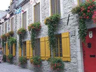
I think it is the most beautiful city I have ever seen. It is super clean and most of the buildings look straight out of the 1700’s, so much so that some areas looks like a movie set. All the buildings are made of stone, decorated with flowers, and set on narrow cobble stoned streets. Even the local McDonalds is housed in a stone building. The old city is towered over by the gigantic Chateau Frontenac, a turn of the century hotel resembling a castle-home of France.

We give ourselves a walking tour of the city, first climbing up the steep stairs from the old port to the city center. From there we walk past Chateau Frontenac to the western city wall. We eat lunch at an outdoor café. The best part about visiting a “French” city is eating awesome French cooking. Unfortunately French entrees are few and far between. Italian is by far the most popular. Go Figure!

West of the city wall along the river is the large Battlefield Park. Known as the “Plains of Abraham” in 1759, it was the site of a decisive battle during the French and Indian War. Intent on taking Quebec, the English under Wolfe spent most of the summer fruitlessly attacking the city from the east. Finally in September, they sailed upstream past the Quebec City cannon and later, during the night, came back, scaled the cliff to assemble on the Plains. Instead of staying behind protection, the French under Montcalm came out to do battle. The French were routed and the city surrendered a few days later. With this defeat England took New France (Canada)
.
In 1820 a large citadel was built into the wall to better protect Quebec City from attack by…. the USA!! And with good reason, we tried to take Quebec (unsuccessfully) during both the Revolution and the War of 1812!

July 6, 2008


July 6, 2008

We drive into Quebec City, QC and explore one of the sites on the outskirts of the city. Quebec City sits at the mouth of the St. Lawrence River where the river is lined with tall cliffs. On the eastern end a river cascades down this cliff forming Montmorency Falls. This waterfall is taller than Niagara but considerably narrower, but impressive nonetheless. We walk around the park surrounding it to take photos at several vantage points. On our way to our new campground in Levis, QC we pass another large waterfall (Chaudiere) cascading from the opposite side of the river. No wonder Quebec has so many aluminum plants; they are blessed with abundant hydroelectric power.

July 5, 2008

July 5, 2008

From Montreal we drove down the St. Lawrence River to Quebec City and stayed at a very large and crowded park thirty minutes from the city. The campground is filled with permanently parked RVs that pass for weekend summer homes for the local residents. I guess when you only have a couple months of summer weather you have to take every advantage available.

July 3rd was the 400th birthday of Quebec City’s founding by Samuel de Champlain in 1608. According to the news the celebration was marred by rain and protests. Quebecans are fiercely protective of their French language and heritage and consider themselves to be an independent nation within the Canada confederation. A large minority is pushing for Separation. Unlike the bilingual signs in the rest of Canada, in Quebec everything is French only… by law. Although I think it is cool to have this bastion of European culture in our midst, I am deeply suspicious of any language, religion, or idea that needs to bar free speech in order to survive. But I am a walking ambassador for the conversion of the world to my common language. All I have to do is say one word in French (Bonjour) and everybody immediately responds in English. Aimee says I shouldn’t take that as a compliment.

July 4, 2008


July 4, 2008

We spent the July 4th holiday having lunch and walking around the old city of Montreal. We didn’t find anything exciting so we walked to the Jazz Festival. I listened to the music while Aimee shopped at a nearby mall.

July 3, 2008


July 3, 2008

We tried to stay another night at this RV park in Westport, NY but it is booked up for the July 4th weekend. Since it is looking difficult to find a place to stay in NY without a reservation we decide to hop across the border to Montreal, Canada. We find a spot at a campground just outside the city. Montreal is hosting a Jazz Festival so we take the subway downtown just in time to watch a small Mardi Gras-like parade. Aimee and I are not Jazz fans, (yet) but we are interested in acquiring the taste. I usually listen to more harmonious music. Montreal’s Jazz Festival is set on a dozen different stages scattered around the circumference of a downtown block. We walk around enjoying several of the groups while dining on crepes made at a sidewalk cafe. Delicious! Unlike our visit to Chicago’s Blues Fest, this event doesn’t have the crushing crowds. Overall it is pretty nice but many of the locals seem to speak some strange tongue.

Wednesday, July 02, 2008

July 2, 2008


July 2, 2008

The city of Lake George, NY is on the southern end of a long narrow lake of the same name. We follow the western shoreline north to where it flows into Lake Champlain. The lake is bordered on both sides by heavily forested hills. Situated on a peninsula at the southern end of the lake is Fort Ticonderoga. Lying on the major water route from New York to Montreal, the fort played pivotal roles in the French and Indian war as well as the Revolution. Three weeks after the Revolution started and before the news spread, Ethan Allen led a surprise attack capturing the fort. George Washington had the large cannons dragged in winter over the mountains to Boston, forcing the British to vacate the city.

The fort is owned by a private group and has a stiff admission fee. We walk the reconstructed fort and peruse the museum. Although the history side is weak, the museum has tons of 18th century artifacts, especially decorated powder horns. After leaving the fort we drive up to the top of nearby Mt. Defiance for an awesome aerial view of the fort and surrounding lake.

From Ticonderoga, we follow Lake Champlain north, spending the night at a private park in Westport, NY.

July 1, 2008


July 1, 2008

We spend most of the morning in Averill Park, NY doing laundry and getting caught up on admin work. At noon we drive north along the Hudson River to Saratoga National Historical Park. Saratoga was the site of a pivotal battle in the Revolutionary War. In 1777 the Revolution looked doomed. New York City had been lost and Washington was on the run. With a decisive northern campaign the British intended to take control of the Hudson Valley, cutting off and isolating the rebellious New England states. General Burgoyne was going to march down the Hudson from Canada, Howe was to sail north from NYC, and St Leger was to cross New York from the west. A great plan, poorly implemented. Howe decided to attack Philadelphia instead, St Leger stopped to siege heavily fortified Fort Stanwix and was repulsed, leaving Burgoyne a long way from safety, running short on supplies. Patriot militias rushed in from all over and dug in here at Saratoga cutting off the British Advance. Eventually Burgoyne surrendered. With the huge victory, France joined the conflict, providing badly needed supplies, and declaring war on Britain.

At the Visitor Center, we watch the movie, peruse the battlefield light map, then take the driving tour around the park. The battle site is a beautiful mostly forested bluff along the idyllic Hudson River. Hard to believe two major battles took place here. After the tour we follow the Hudson eight miles north to Schuylerville where a huge decorated obelisk marks the spot to where Burgoyne retreated and surrendered. Retracing Burgoyne’s advance in reverse we drive north to Lake George where we spend the night at a private park already very busy in anticipation of the holiday weekend.

Tuesday, July 01, 2008

June 30, 2008


June 30, 2008

Cooperstown, NY is a small town with a very popular tourist draw, the Baseball Hall of Fame. As a result the small city has a parking problem and we have to park outside town and take a trolley in. We arrive early to find there is already a crowd waiting, including a group of little leaguers. Besides the small room with all the Hall of Fame plaques, most of the facility is devoted to the history of baseball. The Hall of Fame is located in Cooperstown because Abner Doubleday is supposed to have invented the game here in 1839. It is probably untrue, more of a fable attributed to a local Civil War hero by the influential Hall of Fame founder, Albert Spalding. What is true is that American Baseball is very old and was very popular by the Civil War. We move pretty quickly thru the museum. I can’t say I am much of a baseball fan anymore. I mostly just follow my St. Louis Cardinals who incidentally are the second most winning team in baseball with ten World Series Championships and 17 NL Pennants.

Afterwards we drive east to the Albany area and visit the Martin Van Buren National Historic Site in Kinderhook, NY. There we watch a film about his life and then tour his house. Van Buren, our eighth president, was the first born as an American. This stop actually was interesting and goes a long way to helping Aimee and I remember the chronology of presidents.

We spend the night at a private park in Averill Park, NY.

June 29, 2008


June 29, 2008

From Auburn, NY we drove east thru the cute town of Skaneateles to Syracuse where we caught the New York State Thruway. In no time we are at the Fort Stanwix National Monument. This reconstructed colonial fort sits at the “Carry” connecting the Mohawk River and Lake Oneida. This short portage was the vital link in the trade route that connected the Hudson River with Lake Ontario. As a result both the French and British vied for control of it during the French and Indian War. It was also the site of a crucial battle during the Revolution. In 1777, American patriots withstood a siege by the British who were trying to separate New England from the rest of the colonies. After looking at the exhibits and touring the fort we continue south to Cooperstown, NY where we spend the night at a private park.

June 28, 2008


June 28, 2008

I never thought of New York as the waterfall capital of the US but it sure seems so and not just because of Niagara, although clearly that helps. The last RV park owner recommended coming here to Watkins Glen State Park and I am glad we did. From a trailhead not far from the campground we took a hike along the Gorge Trail and was it pretty. The gorge is a narrow ravine carved out of the multi-layered sedimentary rock by a smallish stream. The water tumbles so quickly down the gorge it forms a reported nineteen waterfalls along its mile length. (I think there are many more but the park got tired of counting.)

The last Ice Age must have really scoured Lake Ontario and the land north of here. As a result the rivers and streams flowing north cascade out of the higher Allegany Plateau. The Ice Age scars can be seen in the Finger Lakes to the immediate north. These dozen parallel lakes are the remnants of the glaciers fingers. From Watkins Glen we head north along the eastern ridge of the largest, Lake Seneca.

At the north end of Cayuga Lake, we stop at the town of Seneca Falls to visit the Women’s Rights National Historic Park. In 1848, the first women’s rights convention was held here led by Lucretia Mott and Elizabeth Stanton. The park is a big disappointment and not up to the caliber of most we have visited. The movie was average and the exhibits disorganized. Plus the focus was just on the 1848 event and little was mentioned of why it took until 1920 for the right to vote. Although I suspect it had something to do with the women’s movement being allied with the temperance campaigns. I too would have opposed women trying to take my beer away. In my younger days I was all for bra burning but now I am not so convinced. Aimee tells me if I want dinner tonight, I better believe. Yes ma’am!

We spend the night at a private park west of Auburn, NY.

June 27, 2008


June 27, 2008

From Campbell, NY it is only fifteen minutes to Corning, NY. Corning is the home of its namesake glass company and the famous Corning Glass Museum. The museum starts out with modern glass artwork and then heads deep into the history of glass. Glass is one of the oldest of crafts first practiced around 1500 BC. For most of history glass making was a labor-intensive art making it reserved mostly for the wealthy. The history exhibits are amazingly extensive and moving too slow even for me, so I know Aimee is bored. I am thinking it was a mistake to have driven out of our way for this place. Fortunately Aimee is moving faster thru the museum and comes back to report there are some demonstrations going on up ahead. We take a break from glass history and watch several live demonstrations on glass making, blowing and breaking. All quite fascinating. Also past the history section are exhibits on glass chemistry, and newer technologies like fiber optics, lenses, Pyrex, and safety glass. Much more interesting for me. There are also exhibits on how manufacturing evolved from hand made to mass-produced. Glass is now such a useful and ubiquitous product but it wasn’t until the last fifty years that glass production (especially flat window glass) was automated.

From Corning we drive a half hour north to Watkins Glen State Park and get the last campsite with electricity.
Newer Posts Older Posts