Tuesday, September 18, 2012

August 27, 2012

August 27, 2012

Because of the prevailing winds, the eastern side of all the Hawaiian Islands is wet and lush while the west is arid. The dry side of Molokai is flattish, brown, and ugly; not at all what you think of as Hawaii. Our goal today is to explore the wetter eastern half. The road east follows or should I say hugs the southern coast. The land rises steeply leaving little land for human use. Too bad because it is very picturesque with the islands of Lanai and Maui looming only ten miles away. The shore is also lined with dozens of fishponds. These rock-lined, man-made sea pens were built by the early Hawaiians to raise ocean fish.

The mountain to our left gets greener as the road gets narrower.  The last half is a one-lane winding road barely big enough for one car.  I can’t see around the corner for oncoming traffic.  Fortunately not a single car passes us going the other direction.  It takes two hours to do the 30 miles to Halawa Valley on the east end.  It is a lush green box canyon with two very tall waterfalls in the distance.  It is thought this valley was where the earliest Polynesians first settled.  This is as close as we are going to get.  The valley is private property and you have to arrange a tour to hike up it.  Instead we eat our packed lunch, while sitting on the beach where the river meets the ocean.


On the way back we stop in town. There we catch up on news at the library and get dinner at the only restaurant on Molokai, a pizzeria. We toast our last night in Hawaii with a bottle of wine.

Monday, September 17, 2012

August 26, 2012

August 26, 2012
This is a relaxation day. While taking a walk along the beachfront, we found out why we have a million dollar view for a bargain basement price. Partly because we are off-season and the snowbirds are back north. But also because the West End is a ghost town. There used to be a golf course between the ocean and us. It has only been closed a couple years, but you can barely tell it existed.

Most of the West End is owned by a company called Molokai Ranch. Apparently they got in a development dispute with the local Hawaiians. In the battle water rights became an issue, an endangered four-leaf clover was discovered and the natives claimed one shoreline of Molokai was sacred. In the end everybody lost. The golf course and hotel were shut down and 120 workers laid off. Most of the locals seem not to want to talk about it, only saying land is a sensitive issue. Unfortunately, most liberals look on companies as a resource to be exploited instead of the source of their livelihood. They shot themselves in the foot.

Molokai is the least tourist friendly of the major islands. Molokai is for those looking for a rustic paradise with the most native Hawaiians. You don’t come here for excitement. There are no stoplights, no elevators, one gas station and one restaurant on the whole island. And now only one nine-hole golf course.

I also shouldn’t read newspapers, especially on vacation. They just make me mad. The local paper had an article on the Kalaupapa Historic Park. So many people live and work on the peninsula that the Park Service now pays to have the weekly trash flown topside. Only our Federal government has flying garbage trucks!
In the afternoon we went to the coffee shop in town where some of the locals play Hawaiian music on the deck. It is the social event of the week in Molokai. The guy from Itasca and his wife are two of the musicians. I was surprised to hear that most of the songs were in the Hawaiian language. Many of the audience members played along with their ukuleles. Several times a few audience members came up and did the hula for accompaniment. Pretty appropriate since hula was invented on Molokai. The show was entertaining, but I think I liked the Pina Colada Smoothies the best.

When we got back I finally found the secret timer for the gas BBQ and made Aimee a steak dinner. While we ate we watched a most amazing colorful sun setting behind the distant island of Oahu, it lasted an hour.

August 25, 2012

August 25, 2012

Of all the Hawaiian Islands, Molokai is the strangest looking. Instead of roundish like the rest, it is elongated, shaped like a shark. Molokai used to be much larger, but all the Hawaiian islands are inherently unstable because they are built of lava piled upon sand. Apparently the land routinely gives way. A million years ago the northern half of Molokai did just that and fell off into the sea. The debris can still be seen in underwater photos. The catastrophe left a scar of massive sea cliffs on the northern coastline. Later a small volcanic lava flow added the distinctive “shark fin” peninsula to Molokai.

That peninsula has a famous or rather infamous history that we are going to explore today. Because it was one of the most isolated spots in the world it was used as a place of quarantine (read prison) of Hawaiian leprosy victims starting in 1866 all they way to 1969. In 1873, a Belgium priest named Father Damian came here and dedicated his life and ultimately his health to their needs. A few years ago he was canonized a saint.

This morning we rose early and drove to the top of the cliff above Kalaupapa peninsula. We are signed up for a tour of the former leper colony. There are only three ways to get there. Fly a small plane, take the mule trip, or walk down the steep sea cliff. Of course we are hiking. At the mule barn we pick up our entry pass (you can’t go to Kalaupapa uninvited). A few hundred yards into the trail we reach the cliff side for our first view of Kalaupapa far below. It is bigger than I thought and way down there. The hike is pretty cool but way tamer than I expected and hoped for. It is only three miles long but drops almost 1600 feet along 26 switchbacks.  The trail was carved out of the cliff in 1907 and widened by the National Park Service. We take our time and enjoy the experience admiring the tremendous lush green sea cliffs that line the whole northern shore of Molokai. After a leisurely 90 minutes we are at the bottom with a beautiful gray volcanic sand beach to our left.

While waiting for our school bus tour to arrive we take a quick peek at this forbidden city. There are a lot more people and cars than I expected. Shortly the mules and the bus arrive and we get aboard. There are four hikers, six mule riders and six fliers on the tour. We get a humorous start with the bus driver moving 30 feet and stopping to talk several times. He gives us a run down of the history of the colony and a description of leprosy (now called Hansen’s Disease.)

Even though this area is now Kalaupapa National Historic Park, the former patients (who are now cured) can continue to live here until they pass on. A dozen have chosen to do so. Along with them, some 40 state health workers, and 40 National Park employees caring for the buildings, also live here. Since so very few of the early buildings still exist I am not sure why the National Park needs 40 people. The current town consists of several dozen modernish buildings on the west side.

At the end of our tour we bus over to the east side of the peninsula and the site of Father Damien’s original colony. This is where the first lepers were dropped off to fend for themselves. There is only Fr. Damien’s restored church and cemetery left as a reminder. On the positive side it is a stunningly scenic location. A great place to eat our picnic lunch. After we finished the four-hour tour we began our ascent back up the trail. It is a lot harder going up, but surprisingly takes us the same time as our descent. At the top we make a brief stop at Palau State Park to check out the park’s superb overlook of Kalaupapa.

That evening we have a dinner of Mahi Mahi on our patio while watching the sun set behind our view of Oahu Island.

Sunday, September 16, 2012

August 24, 2012 Again?

August 24, 2012 Again?
I feel a little like Bill Murray in Groundhog Day. We spent August 24th in Sydney, now we are spending the same day in Hawaii. I know it is because we passed the International Date Line and skipped back in time. But tell that to my body. We also passed over the equator and changed seasons again. We are back to summer and I am not dressed for the humidity. We spend the next several hours in the Honolulu airport waiting for our eight-passenger puddle jumper to take us the forty-five miles over to the nearby island of Molokai. This is the last major Hawaiian island we haven’t visited. After landing we have a conversation with another passenger who, like Aimee, lived in Itasca outside Chicago. He now lives fulltime in Molokai.

We pick up a rental car at the airport. Having driven in Australia in three different vehicles, Aimee has to keep reminding me to now stay right while driving. We stop at the central town grocery to do some shopping. It is tiny, expensive and limited. I have to pinch myself to make sure I am not back in Australia. Disappointingly even the fruit is imported. I guess all the commercial farms like pineapple have shut down in Hawaii. We did ask for fresh fish and got a Mahi Mahi fillet that was still in the back. I can only hope it was locally caught. Outside town we see a sign for a farmers market; so we stop and buy a papaya. I am not a papaya fan.

From “town” we drive to our rental condo on the west end of the island. Our first-floor studio has a nice view of the ocean about two hundred yards off. The condo has no heat or air conditioning, just louvers on the windows that can be opened to let in the breeze. One of the benefits of living in paradise.

August 24, 2012

August 24, 2012
This is our last day in Sydney so we pack our bags and put them in the hotel locker. We head downtown again, this time stopping at several malls. These aren’t the American types but the old world versions from the 19th century. They have been beautifully maintained with glass ceilings, heavy ironwork and mosaic tiled floors. We wander the floors amazed at the many small specialty shops lining each floor and several cafes in the hallway. This is how shopping used to be. For Australians it still is. There is not a single Walmart here. This is probably another reason Australia is so expensive in comparison to the US. Excess overhead caused by high labor content.

We stopped for lunch at a sidewalk café and then walked thru another section of the Botanical Garden. The list of plants in this garden is huge, most I have never seen before. The diversity of Mother Nature is astounding. The garden also has a lot of curved beaked birds called an Ibis. By coincidence this is also the name of our hotel. We thought they were pretty birds until we saw them use the long bill to reach into garbage bins.

Unfortunately our day is cut short. It is time for us to catch our ride to the airport. We ran the gamut of duty-free shops looking to spend the last of our Australian money. At 7pm we board our flight home. I think flying east is much worse than the other direction so we decide to break it up. We fly only ten hours stopping in Honolulu.

I have given all the reasons not to go to Australia. Now why would one still want to go? In some ways Australia is not a place to go to visit, more a place to live. My favorite part is not the terrain or scenery, there is little you won’t see better in the US. Culturally Australia is midway between America and Europe, not quite European and not quite American. Perhaps what the US would be like if we had stayed a British colony.

Australians are more fun and not as stuffy as Brits. Unfortunately they have embraced their Euro counterpart’s love of socialism. After watching TV and reading the local newspapers, I am convinced Australia is turning into a nanny state. Australians also seem to have habit of abbreviating everything. If it can be shortened they do. Victoria Bitter beer is VB, an aluminum boat is a tinnie, poker machines are pokies, motorcycle riders are bikeys. You get the idea.

Australia in many ways is like America in the 60’s. Life is slower paced, jobs are plentiful, gas stations don’t have credit card slots, there are no Walmarts, stores are open shorter hours, highways are all two lane and airlines serve meals.

My favorite part of Australia has to have been the plants and animals. They are so very different from the American experience. Surprisingly though you have to work to see the differences. Kangaroos are not simply jumping around downtown Sydney!

Saturday, September 15, 2012

August 23, 2012

August 23, 2012
We have heard a lot about the Blue Mountains to the west of Sydney so we signed up for a tour to this National Park and World Heritage Area. We were careful to pick an excursion that was small and would allow us time to do some hiking. A few blocks from the hotel we joined a mini-bus with seven other passengers. From Sydney we drove west thru heavy traffic before we caught the Great Western Highway that extends all the way to Perth on the western shore. We took it two hours uphill to the town of Katoomba in the heart of the Blue Mountains. They are hardly mountains. First they are only three thousand feet high; they would be large hills in a continent that had anything bigger. Secondly, they don’t look like mountains. They are more like sheer cliffs. They would be mesa tops or buttes in Arizona.

Our first stop was Echo Point lookout that gives us a panoramic view of the Blue Mountains surrounding a wide heavily forested valley below. To our immediate left are some landmark outcroppings, which according to Aboriginal legend are three sisters that were turned to stone. In contrast to Arizona these mesas and valleys are not barren rock but heavily jungled. Because Eucalyptus trees (Gum Trees) are the predominant species here, the area looks like the mountain jungles of Africa.

From the overlook, we hiked down the cliff wall following the Giant Stairway Trail. It was a steep, damp, uneven rock staircase that hugged the escarpment. To avoid a nasty spill we had to step very carefully. Although we have done longer descents in the US none have been through rainforest. At the bottom of the cliff, but still above the valley floor, we traversed horizontally past Katoomba Falls ending at a rail lift, a leftover from a long-gone coal mine. We climbed aboard for the short trip up a very steep grade. At the top the weather turned ugly with high winds and a few raindrops. Our group decided to skip the next planned walk and we instead drove to nearby Leura for a short walk to Sublime Point, another lookout on the backside of the Three Sisters. From Leura we drove back to Sydney, stopping along the way for a brief driving tour of the 2000 Olympic Park.
During the entire trip our driver and guide talked non-stop about all things Australian. He was surely a trivia king and definitely made the long drive go by quicker.

August 22, 2012

August 22, 2012
This morning we started off with the Sydney Art Museum. It was a snoozer. We then walked thru the Royal Botanic Garden, a huge park right in the center of downtown. The northern point of the park provides the classic postcard view of Sydney harbor.

We then caught up with the second half of yesterday’s walking tour and learned more of Australia’s early history. I laughed when I saw Sydney has a statue of Captain Bligh, the cruel Navy captain infamous for his crew mutinying in Tahiti. It turns out he became the second Governor of Australia and incredibly had a second mutiny of troops here during the Rum Rebellion. Australians think he was just unlucky and doesn’t deserve the bad rap.

After another hour of the walking tour, we got tired of playing tourist and decided to become locals. We left the tour again and had a mocha coffee at an outdoor café and then window shopped in the Rocks area for aborigine art and opals. The opal is the national gemstone of Australia. We found a piece of Aborigine art that we both like. Unfortunately the price tag is $9500. We spent a half hour inside the Rocks Discovery Museum. The first convicts sent to Australia were settled here in sort of an open-air jail. There wasn’t much need for walls. Where would the prisoners go?


In the late afternoon we went to the Opera House and sat at the outside café along the harbor. It is a beautiful spot with the Opera House on one side and the Harbor Bridge on the other. We drank a glass of wine while soaking up the ambiance. We didn’t want to give up our seat, so we ordered a bottle. We thought about ordering food, but seagulls attacked the few brave ones who did; we waited till dark to eat dinner. At 7pm we went in the Opera House to hear the Sydney Orchestra’s rendition of Brahms 2nd Symphony. The Hall had great acoustics, but the performance was probably wasted on us. I think the music would be better suited as a movie background, not a main event.

Friday, September 14, 2012

August 21, 2012

August 21, 2012

Sydney is built along and around the shore of a massive harbor. As a result the city operates many ferries and water taxis throughout the day. This morning we bought a day pass and took a ferry from our hotel on Darling Harbour around the downtown peninsula, under the Harbour Bridge to Circular Quay, the main hub by the Opera House. We then boarded the Manly ferry that took us to a far eastern suburb on the outer headlands. There we walked across a narrow isthmus to Manly Beach on the Pacific Ocean. It is a picturesque semi-circular beach with a great boardwalk. I bet it is jam packed in the summer with people surfing and playing beach volleyball. Even today it is popular with walkers, joggers, surfers, and winter tourists. It is also lined with distinctive Australian Norfolk Island pines. They are very nice but up close don’t seem to have ordinary pine needles. After strolling and doing some people watching, we decided this is the spot to live if we become Sydneysiders.
We walked to the southern end of the beach and up onto the rocky headlands lining the ocean. The seaside vegetation is very strange; pine trees with flowers, and trees growing corncobs. I continue to be amazed by the unique flora and fauna of Australia. We hiked along the cliff top till we reached Sydney Harbor National Park. On the way back we spotted some Water Dragons (large swimming lizards) sunning themselves on the rocks. We had a fish and chips lunch and took the ferry back to downtown.

We walked up to the Sydney Observatory on a steep hill overlooking downtown. It is an historic old building that was used not for astronomy but to set time to aid navigation. It houses lots of vintage astronomical and navigation instruments and a section on Captain Cook’s initial Pacific voyage on HMS Endeavor. His assignment was to go to Tahiti and make a scientific study of the transit of Venus across the sun. Once done he sailed west intent on finding the mythical continent of Terra Australis Incognita (unknown southern land). Fortunately for our trip he discovered it in 1770.
We then hooked up with a Sydney walking tour at 2:30. It was quite nice and informative. We should have done it the first day. Sydney was the epicenter of Australia’s early history. Having recently lost America, England needed another place to send convicts from their overcrowded prisons. They chose this recently discovered “empty” continent. Eventually gold was discovered here and Brits began begging to be sent here. After spending most of the day walking we cut out of the three-hour tour halfway and go back to our hotel to rest. For dinner we had Hunan Chinese, something we haven’t had since our early days in Chicago. After dinner we took the ferry back over to Circular Quay. This time to see the city night lights. Beautiful!

August 20, 2012

August 20, 2012
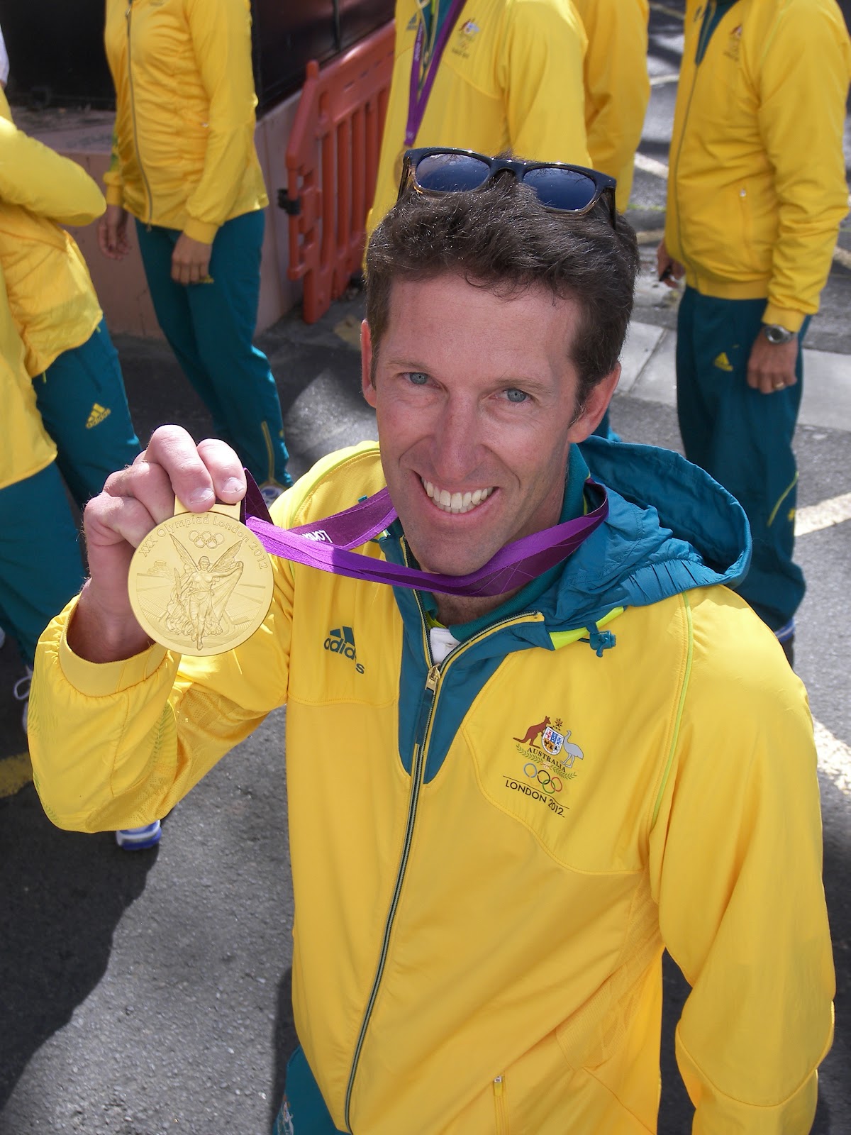
It is a brisk cool morning in Sydney. After spending so much time in Australia’s tropical north, we forgot that it is winter here. We walked toward the historic “Rocks” area of downtown Sydney. On the way we see the streets being prepared for a parade. I tell Aimee it was nice of them to throw a parade for us. She bursts my bubble telling me it is to honor the returning Olympians from London. We take a few pictures of Sydney’s icon, the Opera House, and then watch the parade. It is relaxed and fun. The Olympians stop for photographs, autographs and chats on the way. One lets me touch his gold medal. That is probably the closest I will ever get to one.

Afterwards we stop at the nearby Visitor Center to pick up a map and then walk to Sydney’s other icon, the Harbor Bridge. We walk across the pedestrian portion taking pictures of the harbor. It is easily one of the most beautiful in the world.

Passing a sidewalk café, we spot two Rainbow Lorikeets sitting on a table.  They are brilliant multicolored birds.  We saw one in a zoo lobby outside Cairns and were astounded by their colors.  Who knew they fly around wild here.  One of the Lorikeets repeatedly bent down into a cup of water for a drink.  She must have done this before because she was smart enough to then pull out a sugar packet, and rip it open to satisfy her sweet tooth (or beak).

After a full day of walking we head back to our hotel and have dinner at a pizza joint around the corner on Darling Harbour’s King Street Wharf. It is happy hour and the beers are “cheap”. So far every Australian brew we have tasted has been excellent.

Thursday, September 13, 2012

August 19, 2012

August 19, 2012
This morning we drove back downtown Darwin stopping at the Museum of the Northern Territory. It is part Aborigine art museum, part Australian natural history, and part recollection of the 1974 Typhoon that destroyed most of the city’s houses. Darwin has been a tough place to live. I am not sure how anybody survived the bombings, typhoons, crocodiles and the humidity. The museum was a nice place to spend a couple hours. Unfortunately the only thing they would allow me to photograph was Sweetheart, a huge stuffed crocodile.

Afterwards we turned in the campervan and taxied to the airport. Our driver gave us some of the lowdown on the Aborigines. They make up a third of the Northern Territory population and are delightful people. Unfortunately most don’t work, instead living off welfare and land royalties. No wonder they have so much problems with alcohol and drugs.

I got a window seat for our flight to Sydney. I needn’t have bothered. The Australian interior is flat and boring. We get in late and take a shuttle to our hotel downtown just off the northern end of Darling Harbor. Aimee is glad to be back in civilization again.

August 18, 2012

August 18, 2012

We got up early this morning to finish our tour of Litchfield National Park. Our first stop was the Cascades, a series of small waterfalls in the jungle. Nice but nothing really special. Our next stop is Tolmer Falls. It is a tall waterfall in a narrow canyon with a large plunge pool. Beautiful except the morning sun is in the wrong direction for a good photo; plus no swimming is allowed because it is a sacred spot for the Aborigines. Our third stop is Florence Falls. Like Wangi, it is a twin falls, only smaller and more secluded. I think the plunge pools in Northern Australia are nice because they are deepened during the heavy monsoon downpours. I never expected to have any desire to swim in them; but I can see why Australians rave about their swimming holes. They are very cool. I can’t leave Litchfield without swimming once more. Florence is deep and cold so I don’t venture very far from shore. I wish I had something to help me float.
We did the Litchfield waterfall circuit pretty quick this morning because we luckily have a ranger talk we can join at 10:30am. This one is only offered twice a week. It is at the Magnetic Termite Mound stop. The interpretative ranger gives us the lowdown on termites. Australia clearly has a termite infestation because their mounds are everywhere. Termites have a unique ability to digest complex carbohydrates. We don’t like the ones that eat wood because that might bring our house down. Apparently most of the trees here in the outback are hollow because of wood termites. Now I know why didgeridoos are so common. It is the termites!

Most termites in Australia are actually grass eaters. Since Australia has few grazing animals the termites fill that ecological niche. They build termite mounds to store their food between growing seasons and for protection against fire and flood. Most of the ones we have seen are Cathedral mounds, essentially circular shaped. The mounds in the flood plain in front of us are flat, making it look like a cemetery. Mysteriously they are also all aligned north to south. Scientists are not sure why; they first thought it had to do with the earth’s magnetism but now believe it may be for temperature regulation.

From Litchfield we drove the rest of the way along the Stuart Highway back to the coastal town of Darwin. We parked downtown by the Visitor Center. We didn’t find anything that interested us much so we walked the waterfront stopping at shops and placards along the way. We ended up learning a little history. Australia had its own Day of Infamy. With our Navy in shambles after Pearl Harbor, Japan went on to capture many Southeast Asian ports like Singapore and Manila. In February of 1942, the Japanese bombed Darwin devastating the city. The US lost a destroyer in the raid too. Darwin went on to be a strategic air base for the allies and was bombed repeatedly during WWII.

We also learn that the Stuart Highway we drove through central Australia was the path of the initial telegraph line across the continent linking Adelaide on the south with Darwin on the north. When completed it allowed direct telegraph communication with London in 1872?! I thought this was a misprint but when I later researched the topic, I learned the British were the pioneers in laying submarine telegraph wire across every ocean. They used it to monopolize global trade within their far-flung world empire.

We spent the night at a campground in Darwin and had another delicious meal on the Barbie. This time I grilled chicken shish kabobs. We strolled the campground after dinner. I am amazed at the collection of RVs here. There are no two alike for some reason and many have been modified to survive 4WD roads.

Wednesday, September 12, 2012

August 17, 2012

August 17, 2012
Nitmiluk National Park’s English name is Katherine Gorge. Much of the interior is very hard, flat sandstone a hundred million years old. In this park the Katherine River has carved its way through the rock in a zigzag fashion following fractures in the land.

We want to canoe up the river through the gorge. But since Aimee is still recovering, we opt for the two-hour cruise instead. Since this is the dry season and the water is low, the boat has to stop along the way at a series of exposed rapids. There we walk a few hundred yards to a second boat and cruise the next gorge. Compared to the canyons of the western US, Katherine is not deep but it is pretty. We see little wildlife except for two freshwater crocodiles, the harmless little cousins of the saltie. It is possible to stairstep your way to five more gorges; since the second is supposed to be the most scenic we don’t continue on. Back on dry land we do a short hike to a canyon overlook and then run through the small Visitor Center museum.


Soon after lunch we hit the Stuart Highway north. An hour south of Darwin, we exit and drive to Litchfield National Park. We have gotten several strong recommendations for it, so we make room in the schedule. It is supposed to be a mini Kakadu. Since it is late we immediately head to Wangi Falls at the end of the park road to find a campsite. The campground is full so we pull into what looks like the picnic area parking lot and hope we don’t get kicked out.

We walk several hundred yards to Wangi falls for a quick look. It is a beautiful twin waterfall in an idyllic setting with a massive plunge pool at the bottom. It is so perfect it looks manmade. We take a short walk (that turned into a long one) around the isolated rainforest that hugs the falls. Aimee gets to see the Flying Foxes hanging in the trees. Afterwards I run back to the camper to get my bathing trunks so I can take a swim before dark. Since there are other swimmers, the chances of a Saltwater croc living here are virtually nil. Salties never pass up an easy meal. The water is nice and refreshing and I make it all the way to the falls. That probably was unwise for me since I am not much of a swimmer. I sink and this water is pretty deep.

Back at the camper we finish our transformation into Australians by cooking a steak on the Barbie. Every campground and motel so far has had communal gas BBQs for guests to use. BBQ is an Australian passion.

August 16, 2012

August 16, 2012

From our campground in Kakadu National Park we drove a few miles to Cooinda and bought tickets for the morning Yellow Water Billabong cruise. Billabongs are Australian lakes that expand and contract with the seasons. In the dry season the animals are forced to concentrate in the shrinking billabong. That makes animal sightings more likely. This area is analogous to our Everglades. It is a beautiful sea of floating grass crisscrossed by water channels. Our large pontoon boat can easily navigate the shallow canals.  I want to see Saltwater Crocodiles.  That is not a problem for they are everywhere.  We see lots of smaller females and one large male.  “Salties” are the meaner, big cousins of our alligators.  Signs are posted at most bodies of water warning against going too close.  Salties like to hunt prey that lingers too long at the water’s edge.  They pounce, drag you in, and drown you with a death roll.


Aimee is in heaven; this cruise is a bird lover’s paradise. We have never seen the variety of interesting and colorful birds anywhere else. Our favorites are the Sea Eagle (a Bald Eagle look-alike), the Jesus Bird (walks on water), the Whistling Kite, the Jabiru Stork, and Azure Kingfisher. We also saw plenty of Ibises, Cormorants, Darters, Egrets, and Magpie Geese. Aimee now thinks it truly is Kakadoooo. Plus our Aborigine captain and guide was outstanding. He could steer the boat, spot wildlife in the thicket, and provide a running commentary without losing a beat.

After the cruise we stop at the nearby cultural center to learn about the Aborigine of northern Australia. We thought it was much better done than the more famous one in Uluru. Nonetheless, we found the gift store to be most educational. The sales clerk was a wealth of info. I thought her best comment was about the derivation of the name, didgeridoo. That is not what Aborigines call their musical instrument but what the English thought it sounded like. If you say didgeridoo several times in low baritone, it mimics the musical sound. We ended up buying three boomerangs painted with Aboriginal art from her.

From Cooinda we drove south through the park. The outback was endless and monotonous. Nothing but flat dry grass prairie peppered with skinny trees. We reluctantly passed the turnout to JimJim Falls. It is supposed to be spectacular but like many spots in Australia, it requires a 4WD vehicle and an extra day to visit.

We eventually hit the Stuart Highway that leads south to Alice Springs. We took it partway to the town of Katherine. There we exited and drove to Nitmiluk National Park. Right past the entrance we saw a grass field full of Wallabies, a miniature version of the kangaroo. We spent the night in the park campground where we ran into several of these little creatures begging for food. Because their front arms are so short, they almost look handicapped when they walk around on all fours.


After dinner I struck up a conversation with our neighbor. He turned out to a fascinating semi-famous character. Although named Jon Muir, he is not to be confused with the famous American naturalist John Muir. This Muir has done some amazing treks, like walking solo across Australia, and skiing to the North and South Poles. He even has some books and DVD about his treks. Jon gave me a rundown about eating “bush tucker” on his cross continent journey. Tucker is Australian for food and bush tucker is what the aborigines used to eat.  http://www.youtube.com/watch?v=vG9zhniND-8

We are finding that lots of Australians are adventurous. I guess it comes with the territory. Which brings me to a fifth reason for not going to Australia. Much of it is not easily reached. There aren’t a lot of roads in Australia and many aren’t paved. We have run into many Australians traveling these rough 4WD roads. They bush camp along the way carrying two wheels, two tires, extra water and gas, and a fully stocked tool chest.

Tuesday, September 11, 2012

August 15, 2012

August 15, 2012
Since we got in late last night we start slow this morning. Our first stop is the grocery store. Since the campervan has a tiny fridge and a limited kitchen, and we are only in it a few days, we have to make some careful choices.

Leaving Darwin we head east along the Arnhem Highway. After several hours we reach Ubirr in the northeastern corner of Kakadu National Park, another Australian World Heritage Site. The drive was pretty boring through a flat expanse of trees. This is the winter dry season. If this was summer, it would likely be raining and the road flooded.
Ubirr is on the edge of the escarpment where the higher interior of Australia drops to the coastal floodplain. The cliff face is hundreds of millions of years old and it looks it. Kakadu garnered international exposure when the movie “Crocodile Dundee” was filmed here. Kakadu is also famous for its Aborigine art. The cliff walls are filled with it, mostly depicting animals found in the region. For a Stone Age culture the paintings are extraordinarily detailed. They make American Indians look like grade school finger painters. This art culture continues to this day with their wonderful blend of modern and impressionism. Even though much of it is simply comprised of dots and circles, it is unique and highly sought after. If it wasn’t so expensive I would love to buy a few pieces.
We next stop at the Visitor center in Jabiru. It has nice displays on the plant and animal life unique to the area. While filling up with gas, we notice a flock of noisy white birds in the surrounding trees. On closer inspection they turn out to be white cockatoos feasting on something in these trees. It is interesting watching them use their beak as a third leg as they climb the trees. Here I thought cockatoos were only found in some impenetrable Amazon jungle.

Our next stop is Nourlangie to view more rock art. This time we have the opportunity to hear an interesting ranger talk. I would appreciate this park much better if we had the luxury of doing it on my time. Instead we are speeding through it. Aimee is not as engaged with this famous park. She is calling it “Kakadon’t”.

We stop for the night in one of the primitive park campgrounds. The southern sky is beautiful and I can hear cockatoos squawking as Aimee cooks dinner.

August 14. 2012

August 14. 2012

Last night our tour bus dropped us off at our hotel in “the Alice” around 8pm. Shockingly there is a locked gate and no night clerk. Uhoh! This could have been a major disaster except for a stroke of luck. Within seconds, another customer showed up. They had the foresight to call ahead for the gate code and late arrival instructions. Whew!

We have another lazy morning planned.  We spend it on the Internet catching up with email and posting pictures.  I would have liked to have seen Alice Springs.  Instead our taxi driver gives us his ten-minute rundown on the town.  Alice is an old telegraph station that has grown to 25,000 people.  We just missed the Henley on Todd, a drunken “boat” race down the bone-dry Todd River.  Just south of town is a secret US intelligence base.  I can only imagine what it costs to feed and house 2000 Americans in the middle of the Australian outback.

At the airport we learn that our flight is delayed three hours and we will be getting in to Darwin long after the rental company closes.  I called them and found for a stiff fee they will stay open late for us.  When we finally arrive, we get our luggage, and wait in a long slow taxi line. It is almost 7pm by the time we pick up our rental campervan.  It is also a manual transmission.  Since it is dark, we go straight to the closest campground a mile away.  Of course the gate is closed and locked.  Again!  We look around and fortunately see an after-hours phone. The clerk gives us the last spot they have and tells the next sorry camper to get lost.  I am not sure whether to curse our bad luck or bless our good fortune.

This campervan rental is an experiment for us.  It seems the right thing to rent when we go to New Zealand in the future.  Aimee doesn’t like it.  Compared to our motorhome this thing is a closet.  We spend the first hour unpacking and trying to find a spot for all our belongings.  Fortunately we had a late lunch at the Alice airport so we aren’t too hungry.

Before we retire for the night, the loudest airplanes I have ever heard start taking off from the nearby airport.  Apparently Darwin is the air force’s home for night training.  Of course the US has another couple thousand troops in Darwin too.  Where don’t we have soldiers?

August 13, 2012

August 13, 2012
I am getting worried about Aimee. Her sore throat is back and her cough sounds terrible. I had expected her to be on the mend by now. There is no doctor for hundreds of miles so I am it. I give her a strict regiment of saltwater gargles and rest. She is not a good patient.
The weather in the Red Centre of Australia is very similar to our home in Tucson albeit in February. Afternoons are sunny and warm while the nights are freezing cold. At home we don’t normally go out till after 10am so we forget how cold it can get. We ventured out last night to use the facilities. We were greeted with a glorious sky. We can confirm that the southern sky has 50% more bright stars than our northern half. I recognize a couple constellations. Orion is the most notable but I am shocked to see it upside down. An Australian points out the Southern Cross for us.  It is featured prominently on their flag.

We have an easy day planned. We fill the rental car with gas ($8/gallon) and drop it off at the resort. Surprisingly there turns out to be a Visitor Center here; and it is both nice and free. We spend an hour learning about the history, geology and biological life of Ayers Rock. A dirt road to Uluru was only scraped fifty years ago. The resort complex is a mere twenty-five years old. Word though has gotten out and now tourists come in droves.

We had lunch in the resort’s “town center”, while watching a young Aborigine play the didgeridoo. This wind instrument is simply a long hollow tree stump. Like a bagpipe, Aborigines use their lips to produce a baritone series of rumbles in an interesting and distinctive music style. For a sample watch the movie, Crocodile Dundee. We had hoped to see more of these Aborigine demonstrations, but most have been cancelled because of “Cultural conflicts”. That seems to be code for “drunk”. Or "high" maybe. The gas we filled up with was a special blend. Apparently the locals like to sniff ordinary gasoline.

This is a good day to leave Uluru. To avoid huge grass fires, local officials carry out of a practice of prescribed burns. Unfortunately the breeze is in the wrong direction and Ayers Rock is hidden in smoke today. We are so lucky that yesterday was clear.

From Ayers Rock resort we board a bus that drives us 300 miles northeast to Alice Springs, the closest “big city”. I thought this tour was a good way to see the terrain. Unfortunately it added travel complexity I could have done without. There is nothing to see. The Red Centre is a mostly flat, dry grassland interspersed with a few stunted trees. The only paved road going north is the Stuart Highway. Like all highways here it is just two-lane. An outback driver needs to be careful. There are two dangers, sleep-inducing monotony and road trains. Road trains are semis that haul three and four trailers to reduce freight costs in the remote outback. The road rumbles and the wind spirals when they roll past.

Monday, September 10, 2012

August 12, 2012

August 12, 2012

There are two sections to the National Park at Ayers Rock. The second is the Olgas, or now Kata Tjuta. The Olgas is another red mountain that sits about twenty miles away. Aimee is feeling a lot better today so we rise early and drive there. We arrive too late for sunrise, but it doesn’t seem the sunrise parking lot was such a good photography spot anyway.

Instead of a single peak, the Olgas have eroded into a tight grouping of red domes. We start our visit hiking the Valley of the Winds. The path takes us up several of the shoulders between the domes. We don’t finish the circular trail; instead turning around after reaching the second overlook. The hike is nice but both monoliths lose their impact when you have spent any amount of time among the more impressive red rocks of the Colorado plateau. The appeal of these Australian monoliths is their dramatic upsurge out of an otherwise utterly flat terrain.

After lunch, we return to Uluru for the six-mile base walk. Aimee is thinking that is too much exertion so she soaks up the sun and waits. Ayers is pretty much a smooth solid monolith but up close you can see quite a few places that look like Swiss cheese. I also see why the Aborigines thought it was sacred. There are water holes at two spots along the base, a miracle in the desert. Several niches around the base also contain wall art.

My fourth reason for not coming to Australia is the cost. It is a major expense to fly to this continent and then on to the scattered tourist sites. Unfortunately the pain doesn’t stop when you get here. Australia is a rich country and their citizens are well paid. Their minimum wage is double our own so everything here is twice the price in the US. And getting worse as the US Federal government prints money like there is no tomorrow.

If Australia is pricey, Ayers Rock is exorbitant. Everything here is trucked in at great expense. You have to want to see this rock to come here. To avoid the overpriced tours that ferry you twelve miles to Uluru and back, we rented a car. This also gave us some much-desired flexibility.

Newer Posts Older Posts