Tuesday, July 29, 2014

July 27, 2014


July 27, 2014

From White Bird, ID we drove north, saw the Battlefield again from above, and to our surprise, just over the next mountain we descended into a flat plain. We crossed it and soon followed a ravine cut into the prairie. It is so odd to see the ranchland on a mesa above us.

In Spalding, ID we stop to visit Nez Perce National Historical Park. Spalding is the headquarters for this park spread over 38 sites in the region. At the Visitor Center we watch the movie about the Nez Perce Indians and their plight once contact was made with white men. Like all Indians they are victims of history. A Stone Age society suddenly thrust ahead thousands of years. They were lost. It would be the same if aliens suddenly arrived on our planet with Star Trek-like technology from the future. Some of us would embrace the change but most of us would try our best to cling to the past. Sadly the world is full of groups that want to turn back the clocks of time and refight yesterday’s battles.

We have our lunch in the picnic area before walking around the grounds. This area used to be the site of a Nez Perce village, and the home of the Indian agent, a missionary (named Spalding), and trading store. Most of it has long disappeared.

From Spalding we followed the Clearwater River upstream to the east. It is a beautiful drive. We think about stopping for the day and camping by the river a few times but it is very hot. We stopped at numerous Nez Perce National Park sites. Most are just pullouts with storyboards about Lewis and Clark’s journey. The Corps of Discovery traveled over the mountains with the aid of Shoshone horses. They then encountered the Nez Perce who fed them, helped them build dugout canoes, and pointed them to the Clearwater River that would lead them to the Columbia River and the Pacific Ocean.

We spent the night at a private park in Kamiah, ID just yards from where Lewis and Clark waited for the mountain snows to melt before heading home.

Sunday, July 27, 2014

July 26, 2014

July 26, 2014

Hells Canyon is the deepest river gorge in North America. It sits in rugged country in northern Idaho making it very inaccessible by road. We could take a four-day float trip through this National Recreation Area. The alternative we settled on was a five-hour jet-boat ride up the Snake River. Pittsburgh Landing, our embarkation point, is only about 15 miles away, but there are tall mountains in the way. We took a shuttle van on the steep forest service road that connects it with White Bird, ID on the Salmon River.
We join eleven other tourists on the large jet-boat. Hells Canyon starts out a large V-shaped canyon covered with brown grass. A mere few weeks ago it was all green. As we cruise south up the Snake River, the gorge narrows and steepens. Most of the exposed rock is dark basalt, a testament to Idaho’s volcanic past. The Snake River is very swift with frequent white-water rapids. The three powerful diesel engines that drive this jet-boat make going up rapids and short waterfalls seem like child’s play. Despite being in wilderness we pass lots of rafters floating downstream. It is making Aimee and I want to do the Colorado River through the Grand Canyon. Along the way we make a couple stops at two historic ranches. The pioneers who tried to ranch here must have led a pretty isolated life as it was a very long walk to any civilization.

Our upstream trip ends at the Hells Canyon Dam, where we stop for lunch and a movie in the dam Visitor Center. Refreshed we reboard the boat for our return trip. It is a quicker trip but much more thrilling. The boat bounces more and we get drenched a few times when the boat prow dips down into the white water. We stop on the way back at a little beach for a swim in the ice-cold water.  As we reboard, the co-pilot (and shuttle driver) offers us a tub of large crawfish he caught snorkeling during lunch.  Aimee vetoed my acceptance.

On our return shuttle ride, we ask our driver what he does during the off-season. This entrepreneur had a surprising list. Among the items this outdoorsman collects and sells during the winter include huckleberries, morel mushrooms, and elk antlers. He mentioned a few amounts and prices and I started calculating in my head. This guy makes a mint off-season from his forest excursions!

Saturday, July 26, 2014

July 25, 2014

July 25, 2014

The only downside to our forest campground north of McCall, ID is the entrance road. It is a narrow one-laned gravel road with a sheer cliff on one side. It is barely wide enough for our motorhome. Since I don’t want to pass another RV on this road, we leave camp at the crack of dawn. This campground is named “Last Chance” for a reason.

From McCall, ID we switch to following the Little Salmon north. In this early hour, there is a layer of fog atop it, probably due to the hot spring that feeds it. We leisurely follow the river till it flows into the mighty Salmon River. Here the canyon turns from steep pine-forested to dry grassy hills with basalt cliffs showing in places.

In the town of White Bird, ID, we make a stop at the White Bird Battlefield, a unit of the Nez Perce National Historical Park. Here was fought the opening battle of the 1877 Nez Perce War. We hike .75 miles uphill to learn that this battle was a bloodbath for the inexperienced 106 cavalrymen. This was despite the partying the Indians did the previous night downing stolen whiskey. The Nez Perce took the captured arms and went on to elude the US Army for another four months.

We spend the night at an RV park along the Salmon River.

July 24, 2014

July 24, 2014

From Glenn’s Ferry, ID we travel northwest to Boise where we catch the Payette River Scenic Byway north. The Payette is named after a French fur trapper who ran the Fort Boise trading post.

The temperature has cooled dramatically. I think we finally found the weather we have been searching for. We follow the Payette River north through a very narrow, beautiful V-shaped valley. As we travel the river changes from a lazy one to all white-water. The river looks very popular with kayakers.

Eventually the Payette enters a wide ranch valley. In the city of McCall we are surprised to find a very bustling resort town on a cute lake. The nearby State Park is full but we find a nice pine forested campground in the National Forest north of town. I think we might have overshot on the weather. It is feeling downright cold. Aimee and I both change into long pants, long sleeved shirt and even a jacket!

Wednesday, July 23, 2014

July 23, 2014

July 23, 2014

On our way out of the City of Rocks we drive by its neighbor, Castle Rock State Park. This state park is a miniature version of the rock wonderland and is part of the same geological formation.

We continue our journey north for an hour and then stop at Minidoka Internment National Monument. Minidoka was one of the ten “relocation centers” where people of Japanese descent were moved during WWII. We walk the 1.6-mile loop around the site, but almost nothing remains from that era. A wooden guard tower and part of the perimeter fence have been reconstructed to reinforce that “relocation center” was a euphemism for prison camp.

Back on the road headed northwest towards Boise, we cross over the basalt-lined gorge of the Snake River. This reminds me that much of southern Idaho is covered in lava from past volcanic eruptions. Near Glenn’s Ferry, we see a sign for Three Island Crossing State Park and an Oregon Trail Interpretative Center. The museum is small but is a great excuse to stretch our legs. At this spot, pioneers on the Oregon Trail crossed to the north side of the Snake River. Depending on water level, this could be a very dangerous proposition. The ruts down the steep hillside are still visible.

Aimee wants to do laundry so we make an early stop and spend the night here in town.

July 22, 2014


July 22, 2014

Since we have such a beautiful view outside our backyard here in City of Rocks National Reserve, we decide to stay and enjoy the ambiance for another day. We spend the morning hiking in, around and atop the many odd-shaped granite pinnacles scattered throughout this small valley. This exposed granite bulge has weathered into bathtub-sized potholes, windows and Swiss-Cheese-like caves. We seem to be the only ones hiking the area. Almost all the other visitors are younger and spend their day climbing the almost vertical rock faces. This is a sport I also did when I was in college. I am glad to see there are still people interested in it.

We spend the afternoon relaxing and reading while facing our rock wonderland. I can’t help but think of the California Trail pioneers from the Midwest who also camped here for a few nights and must also have been awed by this fantasy view.

July 21, 2014

July 21, 2014

After topping off our propane and gas tanks, we left Brigham City, UT headed northwest through arid rolling ranchlands. After crossing into Idaho we leave the interstate and follow the California Trail. After watching the old western movie about it, Aimee can’t believe what a difficult time those pioneers had.

After an hour, we come to a trail landmark the pioneers would stop and marvel at, the City of Rocks. Now a combination National Reserve and state park, with some imagination, it does resemble an old abandoned stone city. It surely is an oddity in the middle of ranch country.

After stopping at the Visitor Center to get oriented, we drive slowly up a very rutted gravel road to the Bath Rock trailhead. We are in need of exercise and this is a perfect spot to stretch our legs. The area is full of massive granite monoliths that we can scramble atop and hike around. We run into several parties of rock climbers scaling the rock faces. Somehow in the maze of rocks we get disoriented and lose the trail we were following and reach a trailhead in the opposite direction of our intended travel. So we follow the road back to our home.

We scout out the camping possibilities and find an awesome site atop a section of slickrock overlooking the valley below. It is spectacular. Our enjoyment is soon ended with the arrival of a big thunderstorm that pelts our “tin can” with a thunderous roar of hail. We survive and are rewarded with a beautiful rainbow.

Monday, July 21, 2014

July 20, 2014

July 20, 2014

We are camped at the beginning of the Nebo Loop Scenic Byway. This forest service road climbs 9000 feet into the Wasatch Mountains and provides superb views of 12000 foot Mt Nebo. Farther along we stop for a short hike to Devils kitchen, which is billed as a mini Bryce Canyon. The Hoodoos do indeed look like Bryce, but the area is exceedingly tiny. Just near the summit of our route, we decide to stop and do a short hike for exercise into the adjoining Nebo Wilderness Area. It is an uneventful hour into a Quaking Aspen forest. Our lone excitement is a distant view of a beautiful Western Tanager. It is a very long downhill ride back to the Utah valley where we catch the highway north. Past Salt Lake City we stop for the night in a private RV Park in Brigham City, UT.

Sunday, July 20, 2014

July 19, 2014


July 19, 2014

We spent the night here in Kanab, UT so we would have another chance with ”The Wave” lottery. I was sure Aimee would come through for us today but after a group of six Frenchmen from Tahiti took six of the ten spots, my hopes were dashed. Not wanting to waste any more negative thoughts with our frustrating government bureaucracy, we left town headed north. We drove past spectacular Utah scenery climbing up the various colors of the Grand Staircase, before finishing with a drive through the long and narrow Sevier Canyon. We stopped for the night east of Nephi, in another “dispersed camping” spot in the Uinta National Forest.

July 18, 2014

July 18, 2014

This morning we make our way northwest rolling downhill from the Kaibab Plateau into the valley below. In the town of Kanab, UT we stop at the BLM office for the Grand Staircase National Monument. There we enter the lottery for “The Wave”. Two years ago we also tried unsuccessfully. I cross my fingers, but unfortunately my lucky charm fails me again. Out of the 32 people present, only ten receive hiking permits. They again all go to foreigners who pay no taxes for the upkeep of this park. At the very least the BLM ought to raise the price of these highly prized permits to raise revenue and offset my taxes.

Feeling very disappointed we walked around the small town of Kanab doing a little window-shopping. Kanab calls itself “Little Hollywood” because many B-rated westerns and TV shows were filmed here. The main street is lined with dozens of placards remembering every star who came through town. One of our stops is a film museum that has collected some of the movie sets that were used in the area. We especially like the adobe building constructed for Clint Eastwood’s “The Outlaw Josey Wales”. This evening at a local theatre, we watch one of the better movies filmed here, “Westward the Women”. It is about the struggles of a group of pioneer women making the trek west along the California Trail.

Saturday, July 19, 2014

July 17, 2014

July 17, 2014

From Flagstaff we journey north along the western edge of the Navaho Reservation. We cross the Colorado River and head towards the north rim of the Grand Canyon. At Jacob Lake, we make a brief stop at the small Visitor Center and learn about “dispersed camping” on public lands. The attendant recommends a spot just a few miles away. It is down a gravel forest road a mile off the main highway. We pull off the road when we find a flat spot. Our campsite is free and we have the whole forest to ourselves. We relax for the rest of the afternoon enjoying the smell of pine trees.

Friday, July 18, 2014

July 16, 2014

July 16, 2014

Back in Tucson, we get the RV out of storage, give it a checkup and load it up with all the essentials for life on the road. We leave Tucson headed north. Past Phoenix we stop at a rest stop to eat lunch. I see a couple tourists taking photos of something on the ground. Curious I walk over to see a tarantula creeping along the sidewalk. This is the second one I have seen this year. This “Arizona Blond” is much larger and is two-tone.

Continuing on we end the day outside Flagstaff. At 6500 ft altitude nestled in the pine trees, the weather is just delightful.

July 12, 2014

July 12, 2014

We are in Lubbock, TX today. We stopped here to visit the Lubbock Lake Landmark. Arriving just before it opens, we find it already crowded. This really shouldn’t be a surprise. People have flocked to this location for 12,000 years. That is because a lake used to sit here. It dried up when settlers arrived and started pumping the groundwater.

In 1936, during dredging, bones and human tools were accidentally discovered. Since then Lubbock Lake has been continuously excavated by Texas Tech University. The oldest bones are from the Clovis Period when the Paleo-Indians hunted the now extinct Columbian Mammoth. We are pleasantly surprised to learn the site is having an “Archeology in Action” open house today. One of the benefits is that we get a guided tour of the facility. The tour starts out in the field where we watch young university students scraping dirt looking for artifacts. Many are international students from Europe and Central America. I am thinking many of these archeology students may opt for a new major after digging in the dirt all summer. Another stop was the screening station where the accumulated dirt is washed to find the smallest of bone fragments and tools. There were also a couple other exhibitions on flint napping and bone cracking. After the tour, we perused the small but well-done museum.

Since we need to get acclimated to hiking, we take a quick stroll along the wildflower boardwalk outside the museum. Dozens of watermelon like vines are growing across the path. We learn they are Buffalo gourds, indigenous to the arid southwest.

Getting hungry, we went looking for Texas BBQ and ran into the Buddy Holly Center, dedicated to preserving the memory of this hometown hero. Outside is a statue of this early rock star. He was born the same year as the Lubbock Lake discoveries. Tragically he died in 1959 in a plane crash with the Big Bopper and Ritchie Valens.


In the afternoon we headed north to Amarillo. Just outside town we stopped at Cadillac Ranch, a small roadside attraction. Here a half dozen old Cadillacs lie half buried in the dirt. We were surprised to find the place packed and even more shocked by the number of paint spray cans littering the area. Apparently young Amarilloans love to decorate the cars. The paint has to be an inch thick on every car. They are very brightly colored.

The reason we are in town is a family wedding. One of our nephews is tying the knot. This is my first Texas wedding, a great opportunity to finally wear my Bolo tie.

Friday, May 02, 2014

April 15, 2014

April 15, 2014

After breakfast, we packed our bags and boarded the bullet train back to Tokyo. This is our last day in what the Chinese referred to as Nippon (Land of the Rising Sun). We are ready to return to the land of sunshine and warmth. We loved seeing the cherry blossoms but we are tired of the rain and cool weather.

Aimee said she is making tacos tonight. I can’t wait. Food was my biggest issue. I might not be the most objective since my stomach hurt part of the trip. We found the food to be rather bland, over reliant on fish, and lacking in meat and fresh vegetables. Sushi was the only dish that came with wasabi (a very tiny dab). Where else is fish on a stick, or bag of dried sardines and almonds, a comfort food?


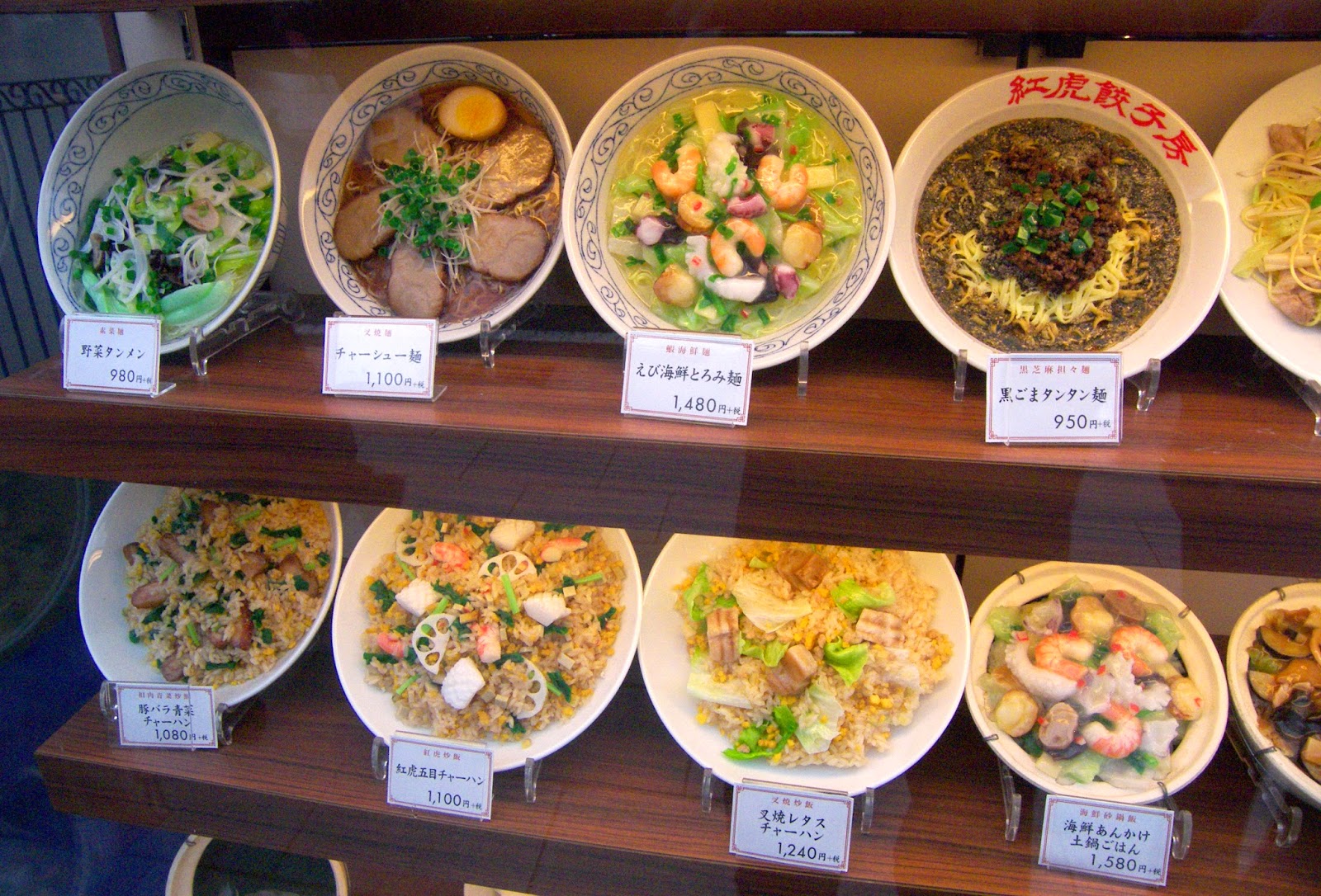
I think the Japanese must also have difficulty choosing food they like. Virtually every eatery had displays of plastic food in the window. It can’t all be for the sake of tourists. The other reason for the plastic food display could be language. Japan probably has the most complex writing system. They have three alphabets. The 2000 Kanji pictograms are used for the adopted Chinese words, but they have two other phonetic alphabets, one for Japanese words and another for foreign ones. Add in the Latin letters they intersperse and I bet there are more functionally illiterate citizens than they admit to. Hence the need for food pictures.


Aimee says what they lack in food, they make up for with politeness and…..toilets. In her mind the Japanese toilets are to die for. She wants one at home. When I sat down on one with its many switches, lights, knobs, music, and heated seat I was afraid I might actually get ejected and sent into space.

In Tokyo we switched trains to the Narita Express that takes us to the airport for our evening flight home to Tucson. Thanks to the International Date Line, we arrive before we leave. LOL

Thursday, May 01, 2014

April 14, 2014

April 14, 2014

After breakfast we rode the train south of Kyoto to Fushimi Inari. We have seen Japanese torii literally everywhere. Every nook and cranny has some kind of Shinto shrine nearby. Inari is the god of rice and business. At this shrine people have donated thousands of vermilion-colored torii. So many that they form a tunnel up the forested mountain. Aimee and I walk about halfway up. I was a little bummed. My camera flash decided to break today making photography difficult in this speckled light situation. Still it is a very cool site.

Back at the main Kyoto train station, we had a Chinese potsticker lunch. Feeling refreshed we walk east to find Sanjusgendo temple. A 400-foot wooden hall houses some of Japan’s oldest statues. It contains a thousand of the thousand-armed goddess, Kannon. These life-size wooden idols were carved in the 13th century. Twenty-Eight guardian deities line the front. I didn’t know Buddhism had so many gods.
Farther east we walk uphill through a fairly modern cemetery exiting at the Kiyomizu Temple. It is not that interesting except for the nice balcony overlooking the city. We return down a tourist avenue doing a little window shopping. Lots of girls are running around in kimonos taking photos. I think they are bridal groups out for a fun afternoon before the wedding.

Late in the afternoon we took the train to the Arashiyama area. Nestled near the mountains next to a river, this less-populated part of Kyoto makes for a scenic stroll. It looks like it will be beautiful when the fall colors arrive. Across the river we pay to climb Mt. Iwata. At the top we are greeted with a great view of Kyoto. We are also met by red-faced Japanese macaques. They run wild in Japan. They are also called snow monkeys because they are the only primates besides us that live in northern climes. Here controlled feeding of the macaques encourages them to stay close. You can buy a bag of apple pieces for a dollar to give the monkeys. Feeding is behind a screen so you don’t get accidentally bit and so the monkeys don’t associate food with humans. Their hands are like mini human ones and the little babies are precious.

After getting our fill of macaques, we stroll back across the river and down a bamboo-lined street. Bamboo is such an odd and wondrous plant. A member of the grass family, it grows the most wondrous stalks. In pre-industrial society bamboo must have been a godsend. So useful. Instant natural pipe of every diameter. No wonder the Chinese were the first to have indoor running water and natural gas heat.

Back at Kyoto train station there are several penthouse restaurants. On the 10th floor we found a Yaki restaurant facing the city. We had a Caesar salad (our first in Japan) and grilled skewered chicken. I wanted nothing to do with the combo options.

Wednesday, April 30, 2014

April 13, 2014

April 13, 2014

We had a western-style breakfast this morning at our ryokan. It was good but the view out the window was better. Unfortunately it is also rainy. We are so glad we had good weather yesterday and were able to see most of Miyajima Island. The weather report says clear skies are to the east, so we check out and catch an early train to Kyoto. That is one of the benefits of a Japan Rail pass. We flash the pass and board any train.

We read that during a few days in cherry blossom season, the Old Imperial Palace in Kyoto is open to visitors. So we take advantage of the opportunity. The palace grounds are behind walls inside a huge public garden. This has not been the home of the imperial family since it was moved to Tokyo in 1869, although coronation ceremonies are still held here. The outside doors/walls on the large wooden buildings have all been slid open showing empty tatami-matted spaces with nice painted walls. We are underwhelmed. The surrounding garden was nicer.

My stomach is feeling a little uneasy so for lunch we stop at McDonalds. I order Chicken McNuggets only because I am not sure how to order a burger plain.

After lunch we take the subway to the Gion area. This is Kyoto’s most authentic area. Like Takayama, it has lots of older more traditional wooden buildings. Gion is also geisha central. Geishas are traditional female entertainers skilled in conversation and the arts. A tourist is unlikely to meet a real geisha, but during Cherry Blossom season a show for tourists is performed at the local theater. We buy two tickets and then find a spot to have some beer while we wait.

Our last-minute seats are in the balcony where we sit on tatami mats. The show is a snoozer for me. It is akin to ballet, geisha style. There are a couple dozen geishas performing an operatic dance while a group of older retired geishas sing and pluck a three stringed banjo. While leaving Gion, we ran into a real geisha running to an appointment. I didn’t think anybody could walk so fast on getas (wooden clogs).

Back at the hotel we walk around the neighborhood looking for something to eat. We settle on a dive bar/grill where we have the combo yaki skewer. The menu picture looks good but half the meats turn out to be something less desirable (probably chicken gizzards.) At least the beer was cold.

Tuesday, April 29, 2014

April 12, 2014

April 12, 2014

From our hotel we take a trolley car to the center of Hiroshima. Within yards of our stop is the famous T-shaped bridge that was ground zero for the first drop of an atomic bomb on August 6, 1945 8:15am. Hiroshima was wiped out. In the intervening years Hiroshima has been completely rebuilt. Except for one domed building left behind as a memorial. This iconic structure only survives with the help of bracing.

An adjoining area was left free of redevelopment. This Peace Memorial Park has a number of monuments to the victims. At the opposite end is the Peace Memorial Museum.

We spent the rest of the morning there. It turned out to be very interesting. One wing is dedicated to history. Hiroshima was a military center and was spared from conventional attack during WWII so the A-bomb’s destruction could be evaluated. I was amused by several references to how Japan was selected as the target (as if there was another enemy still fighting) and how the US only dropped it to justify the huge cost of development. The other museum wing was devoted to the effects of the blast. It contained lots of melted artifacts, including watches permanently stopped at 8:15.

From Hiroshima, we took a local train south along the coast and boarded a ferry to Miyajima Island. Located in the Inland Sea, it is celebrated as one of the three most scenic spots in Japan. Miyajima has long been a sacred island and home of Itsukushima Shrine and its famous floating Torii. As we approach, we can see it is not really floating. The tide is out and the huge gate is in the middle of a mud flat surrounded by a horde of tourists.

Our ryokan has a shuttle waiting to meet the ferry. We are too early to check in, so we decide to explore the island in the interim. We buy some chicken skewers for lunch. We have to eat them quickly as several aggressive deer roam the area. When they aren’t begging for food handouts, they are eating the cherry petals on the ground. After taking a few photos of the Torii, we ride two cable cars up to the central peak of the island. At least it was supposed to be the peak. It was still a long uphill climb to the true island top. Once there we were blessed with great views of the other islands in the surrounding Inland Sea.

Instead of riding back, we hiked down a trail back to the harbor. While scenic, it was not stunning. But then again we are jaded after seeing so many of America’s National Parks. I was hoping to see some of the Japanese wild macaques that inhabit the island but they were nowhere to be seen. Near the end of the trail, we stop at Daisho-in Temple. This temple has it all. Built on the side of a steep hill, it has gardens, statues, koi pond, a large bronze bell, and a lantern hall. It also has a bunch of metal wheels inscribed with Buddhist sutra. I give them a speed-read spin.

We check into the ryokan and find it to be our nicest accommodations by far. Our room comes with a sitting room facing the Floating Torii and Hiroshima Bay. The restaurant was very accommodating in the Kaiseki menu and allowed us to substitute lots of cooked alternatives. Still it had many items uniquely Japanese. The meal included a tiny glass of Plum liqueur, Kobe beef we cooked ourselves on a hot stone (sukiyaki), eel boiled in a pot of broth, and baked oysters.

After dinner, we walked out to take evening photos of the Torii. The tide is in and it is truly “floating” now. First built in the 6th century when commoners were not allowed to step foot on the sacred island, the torii was built in the water so pilgrims could sail under the gate and approach the shrine without landing. As I try to take photos, the tradition continues, as I have to fight tour boats cruising under the torii.

Of course after we return to our room, Aimee wants to visit the onsen. She can’t wait to bathe naked with the geishas again.

Monday, April 28, 2014

April 11, 2014

April 11, 2014

We meet up with a guide in the lobby of our Osaka Hotel and take the train to nearby Kyoto. Kyoto was the capital of Japan and the home of the Emperor for over 1000 years. For being a major tourist attraction, Kyoto doesn’t have a very good transportation system. We take a long city bus ride across town to Kinkaku-ji “Temple of the Golden Pavilion”. This beautiful structure was first built by a Shogun around 1400 AD and later turned into a Buddhist temple. Since it is a sunny day we enjoy walking the nice gardens that surround it.

We have an early lunch at what would pass as a Denny’s at home. Aimee and I both have the Friday Special of tempura with rice and noodles. My stomach is doing pretty good to be eating Japanese food again.

After lunch we took another bus to Nijo Castle. This was the Kyoto home of the Tokugawa Shogun who governed from Edo. While double-moated, this primarily wooden structure’s main purpose wasn’t defensive. Its lavish decorations were designed to intimidate and awe the feudal lords who came to pay homage to the Shogun. It is filled with large tatami-matted rooms for meetings. A couple of the rooms were filled with Samurai mannequins that make me think of the Shogun TV mini series of my youth. The most amusing part of the “castle” was the wooden flooring. It creaked terribly, like a flock of chirping birds, on purpose. It is called the nightingale floor and it creaked to warn of intruders (think ninjas in the night). The medieval version of a burglar alarm.

From Nijo Castle, we walked thru a shopping area and then on to a tea ceremony. Apparently how you brew and pour the tea is important in Japan, especially for a geisha. It was cute but not my cup of tea (pun intended).

From Kyoto, we took the Shinkansen bullet train to Hiroshima. At the train station, we looked around for some snacks to buy. We are a little hesitant as most items were fish-flavored or had fish in them. We bought something green hoping it was wasabi flavored. It turned out to be pea or asparagus flavored instead. While not good it did go well with the beers we bought for the ride.

As we shoot past the countryside on the bullet train, I am shocked at how little living space the Japanese have. Japan is the size of California, but with three times its population. 75% of the terrain is mountainous, so everybody is squeezed into the little bit of flat land available. Urban areas are mostly apartment buildings while rural areas consist of small houses built right on top of each other. This may be the reason the Japanese are so polite. It is the only way to survive crowded together.
In Hiroshima, we have a dinner of teppanyaki. Yaki means grilled, so we are safe whenever we see that word.

Sunday, April 27, 2014

April 10, 2014

April 10, 2014

At 6:30 the monks of Koyasan summoned us for their Morning Prayer service. It was fifty minutes of constant chanting, burning of incense and occasional ringing of a gong. Afterwards we had breakfast. Since my stomach is still queasy, I watch Aimee eat. She tells me it's ok, but not as good as dinner.

After breakfast, I slept for another two hours, before checking out. We walked the cemetery path again to see what we missed in the dark. Most of the graves are marked with a stone pagoda. The temple at the end where Kobo Daishi is said to rest in eternal meditation is now open. One room has 10,000 donated lanterns kept eternally lit. We left by the south exit and took the bus to the center of town. There we visited two Buddhist temple complexes, Kongobuji, and the Garan with its colorful Great Stupa.
Afterwards we retraced our journey taking the funicular down the mountain, and a train to Osaka. Like Tokyo, Osaka has an extensive subway network. We took it to Osaka Castle Park. The castle is a massive double-moated fortress with a beautiful Japanese style keep or donjon in the middle. The donjon is a concrete reconstruction with a very detailed history museum inside. Osaka Castle played a major role in the unification of Japan. We are approaching the 400th anniversary of the Siege of Osaka. We climb the eight story structure whizzing past the exhibits. Aimee won’t let me read about the feudal wars waged from here.

We spent the night in Osaka. My stomach is feeling much better, so have pizza for dinner. It is still too early to try Japanese food just yet.

Saturday, April 26, 2014

April 9, 2014

April 9, 2014

I woke up this morning with the room spinning. I had a bout of vertigo a couple months ago. What a terrible time for it to recur! This time it makes me nauseous. I skip breakfast. Aimee goes without me and says the Western-style meal was great. I can’t even think about food.

We are on the move again. We check out, send our luggage ahead and board the long train back south. I am glad it is a long ride, as I have to run for the bathroom several times. Since the nausea is persisting I am guessing this is more than vertigo. I must have eaten something a westerner shouldn’t have. Aimee blames the raw firefly squid.

In Osaka station we take the subway to the main southern train station. There we stroll the covered pedestrian shopping streets. The area is high-intensity modern. Surprisingly in the middle of it is a little cultural oasis called Hozen-ji Temple. For lunch we eat at McDonald’s. Aimee has a burger while I sip a Coke and eat an ice cream cone. That is the most my stomach can tolerate.

We spend the day making our way to Koyasan. To get there we take a local train south from Osaka. Koyasan, now a World Heritage Site, is a revered Buddhist enclave. In ancient times, pilgrims traveling there would climb a trail to this mountaintop oasis. Since I am under the weather, we take the modern way, a funicular train up a very steep grade. At the hilltop station, we catch a bus to one of the many Buddhist monasteries offering shelter to travelers.

A monk showed us to our room. We are invited for dinner at six. Since most Buddhist monks are vegetarian, there is no raw fish at this meal. At least that is what Aimee told me. I tried a little miso soup and had to immediately run for the exit, and not because I mind a vegetarian meal occasionally.
Temporarily feeling a little better, or needing some fresh air, we walk the mile trail to the 9th century shrine and mausoleum of Kobo Daishi, a monk famous for bringing Chinese Buddhism to Japan. The pathway is illuminated with stone lanterns. Lining the path are thousands of graves, Japan’s largest cemetery. Everybody wanted to be buried in this sacred spot, next to Kobo Daishi, including Emperors and Shoguns. The dim light, moss-covering, and towering cedar trees make this an especially spooky journey. I forgot my stomach hurts.
Newer Posts Older Posts