Saturday, May 13, 2017

May 7, 2017

May 7, 2017

With cool nights, I chose to sleep outdoors on a cot with Aimee in the tent next to me.  Right above me shined the Big Dipper.  When I awoke in the middle of the night, I was amused to find the constellation had revolved 90°. Without consulting a watch, I knew I had been asleep exactly six hours or one quarter of a day.

Despite being in paradise, three days of camping is our limit.  We are ready for showers and a nice bed.  We begin the long process of returning.  We are up at the twilight of dawn to pack up.  After dropping our bags at the corral, we start the 10-mile hike.  In Supai, we see a long line of people hoping to get the few helicopter rides out of the canyon.  It is not expensive but apparently it is first come-first serve.  By luck, today is cloudy and unseasonably cool making the uphill grueling hike a piece of cake.  We complete it in 4.5-hours.  Surprisingly our bags arrive by horse shortly after.  Despite what I had read on the Internet, the Havasupai turned out to be very friendly and good at keeping their tourist operation running efficiently.

The hardest part is now the 6.5-hour drive home.  We have stop for cokes and coffee to stay awake.

Friday, May 12, 2017

May 6, 2017

May 6, 2017

Today we are relaxing and enjoying this water wonderland of the Havasupai (Turquoise Water People). Aimee and I are both astonished at the scenery.  It is like a hidden Garden of Eden (but for the hordes of other tourists).  We visit Upper and Lower Navajo Falls but spend most of our time in the sheltered cove of the iconic 100-foot Havasu Falls. The spray of the 70° water is in sharp contrast to the dry 100° air temperature outside.  We watch dozens of teenagers jumping off cliffs while filming themselves with Go-Pros and Selfie sticks.

In the evening, we attend a church service led by the pastor that organized this trip.  Visiting Havasu is difficult and not only because of the remote location.  Getting a reservation at the campground is virtually impossible.  The Indians never answer the telephone.  Apparently they prefer to deal with groups. Several commercial groups that charge hefty fees were camped around us.  We got lucky and learned the name of this minister last fall by sheer accident.  He has lead 53 church trips here.  He is now 85!  He announced at the service that this would be his last large trip to Havasu!  Aimee and I give thanks for being able to accompany him on this trip.

Thursday, May 11, 2017

May 5, 2017

May 5, 2017

Today our goal is to explore Havasu Creek downstream.  After hiking the mile to the other end of the campground we arrive at the top of 210-foot Mooney Falls.  Unfortunately, the only way to reach the base is a wet, muddy, scary climb down the cliff wall.  It has been made safer with the addition of cables and ladders but Aimee is not impressed.  I scamper down the wall, and take some photos for her.  On my way back up, I find Aimee coming down with some hunky guy who says he does Search and Rescue work.  I should be jealous but at least he was able to cajole her down the cliff.

From Mooney we continue several miles downstream.  On three occasions we had to shift to ‘water shoes’ and cross the swollen creek. The trail seems to never end. We persevere and are rewarded with Beaver Falls, a spectacular series of cascades.  The spring-fed water of Havasu Creek gushes from the bottom of a cliff wall after filtering for generations through limestone strata. On the journey it picks up a high mineral content. On exposure to the air, the limestone drops out of solution, giving the water a turquoise color.  The minerals also build up on every surface.  Over time river rocks become encased in white Travertine bridging gaps, building a descending staircase of water-filled terraces.

It is a long hot trek back to camp. We relish every time we have to cross the cooling creek.  By the time we return we are exhausted and need a few hours rest.

Not having camped for many years, I found out my skills and equipment leave much to be desired.  Our dinner last night was a dehydrated meal I bought many years ago.  It was not good.  Fortunately, we had enough snacks to hold us over. Also the air mattress Aimee used developed a leak making her bed not so comfortable. I also neglected to tell her not to store our food garbage in the tent. After returning from this hike, we found a mouse had chewed through the tent and into her peanut sauce remnants. I did get a small reprieve tonight. Despite being almost 20 years old, our lasagna and blueberry cheesecake was delicious!

Wednesday, May 10, 2017

May 4, 2017

May 4, 2017

We are up at dawn continuing our journey.  We follow old Route 66 west till we hit the Hualapai Indian Reservation where we turn north and drive two hours across empty expanses of pine forest and scrub ranch until the road ends at Hualapai Hilltop.   Hilltop is a little bit of a stretch, as it should really be called “Cliffside”.  Cars are parked along both sides of the road for the last mile where it hugs the narrow rim of a canyon.  We luck out and find the only open parking spot at the very end near the trailhead.

We are here to join a few hundred people wanting to visit the Havasupai Indian Reservation.  There is no road access, only a long dusty trail.  Since my backpacking days are long gone, we drop our packs off at the top.  The Indians will load them onto horses for transport to their campground.
 
With only a daypack, Aimee and I set out ahead of the horses.  The trail starts with a steep 2000-foot descent of the canyon wall along a dozen switchbacks.  Then we follow Hualapai Canyon for many miles, with the walls growing taller and taller. After 6.5 miles, we merge with Havasu Canyon.  It is dramatically different.  A large spring disgorges water turning the desert environment into a narrow green riparian oasis filled with cottonwood trees.

We turn left and follow Havasu Creek 1.5 miles to a wide spot in the canyon and the Indian village of Supai, where 200 Havasupai live. The USA considers it the most remote community in the lower 48.  There is a small grocery, elementary school, and post office. The tourist office issues us a wristband showing we paid our entrance fee.

Downstream of Supai, the creek drops in elevation precipitously, forming thousands of waterfalls.  Most are small cascades but the largest have 100 and 210-foot drops.  Two miles farther down a very hot sandy trail, we enter the campground.  The campground hugs the next mile of creek-side land.  It is free-form.  Just drop your tent on any open area.  After a few minutes sweating in the sun, we decide a spot near the shady cliff is our new home.  We drag an unused picnic table close.  Our temporary home is crowded but reasonably close to the entrance, the outhouse, and a natural spring.

Aimee took up the challenge of being a camping gourmet and found an Internet recipe.  She made us a delicious chicken in peanut sauce wrap. While she is “cooking” I walk to the corral and grab our duffel bags.  After lunch, we setup camp, and then relax.  In the late afternoon, we enjoy the refreshingly cool waters of Havasu Falls.

Monday, May 08, 2017

May 3, 2017

May 3, 2017

Just after lunch we loaded up the car and drove to Northern Arizona, spending the night in a small hotel in Seligman, AZ.  This town halfway between Flagstaff and Las Vegas used to be a stop along old Route 66.  My family passed through here in 1965 on the way to California.  Not much has changed since.  It now calls itself the Birthplace of Historic Route 66 because some residents led its preservation efforts.  Before dinner Aimee and I walk along some of the old roadside businesses that are now littered with old-time American memorabilia.

Sunday, March 12, 2017

March 11, 2017

March 11, 2017

This morning we drove downtown to the annual Tucson Book Festival on the University campus.  I am dragging Aimee here because many of the laboratories have an open house during the event.  Our first stop is at the Science City tent to get tour tickets. 

After perusing the hundreds of book seller booths we head over to the Optical Science lab. The U of A is known for its Astronomy department.  An offspring of this focus (no pun intended) is world class optical science.  A major innovation has been Adaptive Optics, warpable lenses that can eliminate the atmospheric distortion of earth-based telescopes.  We listen to a short lecture on microscope advances.  All the new advances are using computing power to push the traditional limits of optics. We also saw a demo on Holography and another on Thermal Imaging with Infrared.

A couple doors away is the offices of the National Optical Astronomy Observatory that runs nearby Kitt Peak.  They turned one of the offices into a giant Camera Obscura. Also known as a pinhole camera, light bounced off the exterior scenery passes through a small hole in the side of the building and is magically projected onto a screen inside.  I remember doing something similar as a kid with a cardboard box to view a solar eclipse.

We finished with a tour of the Insect collection of the Arthropod department.  The manager showed us his archives of all the insects found in the local area. Not surprisingly with our warm weather, it is huge. As part of a community outreach project, he also identifies insects for locals who bring in specimens.

Saturday, March 04, 2017

March 3, 2017

March 3, 2017

Southern Arizona, with its dry weather, clear skies, and scattered mountains, is a mecca for astronomers.  This morning we left early with our neighbors to drive sixty miles southwest to Kitt Peak. It is another twelve miles of windy road to reach the 7000-foot summit.  This mountaintop is the home of the National Optical Astronomical Observatory. The Soviet launch of Sputnik in 1957 spurred the USA to setup this government agency to fund and expand astronomical science.  One of the first projects was the development of Kitt Peak.

Kitt Peak today is crowded with more than two-dozen telescopes. Three are open to the public.  We sign up for a guided tour of each. The first up is the McMath-Pierce Solar Telescope. It is not only massive, but unlike any others. It is 500-foot long and angled at our latitude of 32°.  More than half of the length is buried in the mountain. On sunny days (not today) a large mirror is pulleyed up to the top. Sunlight is bounced down the length and then back up to the surface.  There, a detailed yard-wide solar image can be studied.  Despite its size, this 55-year old instrument is now rarely used and is ready for the trash heap.

Our second tour is to one of the oldest telescopes, the 84-inch.  Finished in 1964, it originally was fitted with a camera.  Now telescopes uses digital sensors or more likely spectroscopes for analyzing the different colors of the light.

After eating our picnic lunch in the car, our third tour is a half mile hike to the largest telescope, the Mayall 4-meter (158 inch).  We can easily see this 19-story behemoth from Tucson. Data from this instrument led to the new but controversial theory of dark matter.  As a bonus, from the outside observation deck we get a great view of the mountain and the surrounding valley.

Despite the size of the telescopes on Kitt Peak, none of them break into the top 25 largest anymore. Money is now pouring into mega telescopes that use multiple mirror arrays. Kitt Peak is becoming a dinosaur and is in danger of losing its funding.  The new telescopes are moving to Chile and Hawaii; both are much higher and less tainted with urban light.

Wednesday, February 01, 2017

January 21, 2017

January 21, 2017

Our Indochina adventure is over and now the long journey home begins.  After a leisurely morning we head to the small Phnom Penh airport for our 11am flight to Taipei.  I waited in the Business class line to see how much an upgrade would cost.  I was hoping it would be reasonable; it wasn’t.  In any case, we got checked in a few seconds earlier and managed to get one aisle seat on the second leg to LAX.  We thankfully had a tail wind and the flight was three hours shorter than before.  We made it through customs fast enough to catch an earlier flight to Tucson.  We are more than ready for some dry weather.  Unfortunately I think we must have landed in the wrong city.  It is cold and damp here!


We had a wonderful time in Vietnam and Cambodia with many fond memories.  The two countries have a long and interesting history that most Americans know little about.  Our view is so clouded by our troubled involvement in the War.  Both countries seem to have mostly forgotten the war.
 
Indochina is still mostly rural and agricultural. Everywhere we went, we saw rice paddies in various stages of production.
 
Yet, both countries have embraced capitalism and free-market reforms, which are driving their economies with people surging into the cities.  The dominant form of transportation is the Motorcycle.  One in two people own one. It is common to see an entire family crowded on one or another motorcyclist transporting a truckload of merchandise.  We even saw motorcycle UPS drivers and 2-wheeled Uber “cabs”!

The pedestrian is at a distinctive disadvantage.  Sidewalks are plentiful but they are crowded with vendors, motorcycle parking, eateries, and drivers avoiding traffic congestion.  That leaves us walkers to the dangerous edge of the road.

One of the joys of travel in Indochina was the food.  It was wonderful, fresh, full of seafood, and immaculately displayed.  It is an interesting mix of Chinese, French, and local traditions. With so many good choices, it is no wonder that Vietnamese eat street food for many meals. Aimee and I are just surprised that they love to eat sitting on miniature kid-size plastic seats!

One of the other surprises of our trip was how often we saw people getting their picture taken in traditional dress in front of local scenery.  And it was not just the girls, but guys too.  One fellow traveler said it was an Oriental preoccupation with their online persona.  Either way I took advantage and took lots of photos of pretty girls.


Saturday, January 28, 2017

January 20, 2017

January 20, 2017

Today we are on the move to learn about more recent Cambodian history.  We fly to the current capital, Phnom Penh.  To save time we stop at a bakery for a snack.  And then on to the Killing Fields Memorial. During the Vietnam War, Ho Chi Minh supported the Khmer Rouge (Socialist Cambodia) movement. Aided by the US decision to extend bombing into Cambodia, this minority group was able to seize power in 1975. They immediately drove everyone from the cities into the country, and started killing anyone with an education. It was only stopped when the Vietnam Army, fearing UN intervention, invaded. It was a moving story made more so by the fact our local guide’s father was taken away when he was 2 years old, never to be seen again.

The memorial is one of several execution sites discovered. Some excavation was done to learn the extent of the murders, and these bones were placed in a memorial stupa. The rest are still in situ. As we walk around the small area, we see bones and clothes emerging from the ground as the rain exposes them.  There is one spot where children and women were found, another with decapitated bodies, and a third pit containing 450 skeletons. In all 2-3 million Cambodians were believed to have been killed. The systemized murder seems eerily like an unsophisticated Auschwitz.


Afterwards, we went to the Royal Palace, or at least we tried to.  We got stuck in traffic in an area without traffic lights. The traffic just came to a halt.  I am never going to complain about red lights again. We finally made it through with the assistance of a traffic cop.

We toured the palace following a group of monks in orange robes. The architecture all looks modern Oriental. The current elected king, only a figurehead, still lives here.  A handful of buildings are open to the public, including the Coronation Hall and the Elephant Mounting Room.  There are also several memorial stupas on the grounds. The star attraction is the Pagoda. Its floor is completely covered in silver tiles. Unfortunately the tiles are tarnished, in poor condition and now mostly covered by carpet.
 
Since it is late in the day, we made a one minute dash through the National Museum which houses lots of artifacts recovered from archeological sites throughout Cambodia. Then it was back thru heavy traffic to our hotel.  Unfortunately our farewell dinner is back downtown so it is late by the time we are done.  That turned out okay as we stayed up to watch the Inauguration at midnight.

Friday, January 27, 2017

January 19, 2017

January 19, 2017

Today we are back at Angkor to see more of the temples. To get around this vast city, we hired a Tuk Tuk and driver. This is a motorcycle taxi, ubiquitous in Asia.

Our first stop is Thommanom, just outside the east gate of Angkor Thom.  It was built in the 1100’s when the Khmer were still Hindu.  It is small but seems well preserved for its age.  Across the road we visit Chau Say Tevoda.  It is of the same age and design but doesn’t seem to have been reassembled as well.

Angkor is a land of temples, hundreds, and I am already thinking I am “templed” out. Fortunately our next stop is at Ta Prohm.  This large, relatively flat temple is still mostly in the condition it was found.  After Angkor was abandoned the surrounding hot steamy jungle repossessed it.  You can’t believe the size of the trees that have grown up, through, and around the walls of this temple.  They add a mysterious aura to the scene but are vastly destructive.  Left to nature, the roots will slowly and inexorably topple every stone.  Authorities need to remove the trees to stabilize the structures, to the dismay of tourists like me.  The temple scenery is very cool but for the onslaught of Chinese tourists wanting their photo in front of every vine-covered wall.

Our next stop is across the street at Banteay Kdei. This is a Buddhist temple monastery with lots of towers, that strangely has a hall decorated with dancing girls behind it. Apparently being a monk in those days wasn’t so bad.

We finished our morning at Srah Srang.  Angkorites loved to dig holes. If it wasn’t moats around their temples, it is a reservoir like this one.  They either did it for water storage or drainage control, or possible recreation.  This one has a nice stage on one end with statues of lions and serpents.

After lunch we visit the premier tourist draw of Cambodia, Angkor Wat. The name means Capital (or City) Temple.  Appropriate since it is the largest religious monument in the world. It is almost a mile square and completely surrounded by a moat. It was built in the early 1100’s, almost 100 years before Angkor Thom and Bayon.

We enter crossing a long causeway to the island and then through a temple-like entrance monument.  Past the gate there is a long avenue to the center complex. On either side of the path are reflecting pools.  We are lucky.  Today we have clear skies with no rain and little wind.  So I can take the classic photo of Angkor Wat with blue sky in the background and a perfect reflection in the pond.

The core of Angkor Wat consists of three concentric rectangular galleries.  The central one has four corner towers with a 210-foot central tower.  The gallery walls are decorated with a continuous bas-relief sculpture telling some linear tales.  They are in superb condition probably because they are covered and coated with lacquer.  With the large moat, the destructive vines were also kept at bay.  In one of the inner courtyards, a couple of monks are selling fortunes.

The Bakan or Inner Gallery is only accessible by a set of steep stairs and visitation is limited.  We wait in line almost a half-hour for our turn.  It is anti-climatic but does give us a good view of the surroundings.  Surprisingly, the courtyard looks like it must have been filled with water to represent the ocean.

We exit the backside, walking past more friezes to leave the way we came in.  We take our Tuk Tuks on a very dusty ride back to the bus. It has been a long, muggy, hot, but interesting day.  Unfortunately, our guide is not finished with us.  From Angkor, we drive forty minutes down the Siem Reap River to a dock.  There we load onto a boat that carries us down river till it empties into Tonle Sap Lake.

Tonle is a major river that flows into the Mekong.  Here it passes through a large geologic depression where it spreads out into the largest lake in Southeast Asia.  It expands dramatically during the wet season.  The lake is a major source of fish.  Fisherman live along the shore and in the water on stilts like we have seen in the Mekong and Halong Bay. There is even a floating church. While interesting to see the lake and the sunset, we don’t really need to see another floating slum.
 
Back in Siem Reap, we still are not done to my dismay.  I am not feeling well, maybe allergies, maybe the heat, or likely both.  We stop at a couple markets before we finally make it back to the hotel at 7:30.  I spread out on the bed under the air-conditioning.

Wednesday, January 25, 2017

January 18, 2017

January 18, 2017


Our tour of Vietnam is over.  Today we are headed west up the Mekong River to explore Cambodia. We have an hour flight northwest to Siem Reap, Cambodia. Surprisingly we fly on a Lithuanian Airline with an Eastern European crew.  It is most definitely a Small World.

Despite the short flight, it is apparent we have transitioned to a different culture. The people are a little darker and look more Indian and less Oriental.  The writing is vastly different, a script of Indian origin. Cambodia is the land of the Khmer people who at one time ruled over a large swath of Southeast Asia.


We board our bus, stop for a quick snack lunch of spring rolls and a beer, and then drive to the nearby Angkor Archeological Park.  Angkor was the capital of the Khmer Empire at its peak. Unfortunately the Khmers had bigger more aggressive neighbors. Vietnam swallowed the Mekong Delta area, and Siam attacked from the west. The town name, Siem Reap, even means Siam Defeat. Angkor lasted as the capital of Khmer until 1431 when it was sacked by the Siamese.  The capital was moved to a safer location at Phnom Penh.


Archeological surveys have revealed Angkor was an immense metropolis, about 20 miles square, and the largest pre-industrial city in the world. It is estimated over a million people lived here. We start our exploration at Angkor Thom (Great City).  This royal “downtown” is a large walled and moated square almost two miles across. It is entered via a gate and long bridge guarded by 54 stone gods and 54 demons.


In the exact center of Angkor Thom is Bayon. This royal temple, built around 1200, is crowded with 54 towers that are supposed to remind us of Himalayan peaks, home of the gods. Each one has four massive faces of Buddha. It is constructed of carved sandstone atop a base of red stone. We climb through crumbling passageways, past lots of reliefs of dancing girls, up around the high center tower with Buddha staring at us everywhere. There are macaque monkeys running around the exterior.  As one stole food out of a garbage can, I was reminded of the shoe-stealing macaques at the Taj Mahal.


A half-mile north is the Royal Palace.  It is fronted by the long Terrace of the Elephants, which the king used as a viewing platform for public ceremonies.  Inside the Palace we visit the Celestial Temple.  This three-tiered moated Temple is Hindu, from before the Khmer conversion to Buddhism. The rest of the palace is gone having been made of wood. Only Gods were allowed to have homes of stone. We exit through the Terrace of the Leper King. It has hundreds of bas-relief figures carved on an unusual double-walled structure.

This evening we have a Cambodian feast in the hotel.  We start with a squid salad served on a banana leaf and finish with Curry Chicken.  Cambodian food resembles Thai without the coconut milk.

Monday, January 23, 2017

January 17, 2017

January 17, 2017

Our goal today is to explore the Mekong Delta.  The Mekong River is the world’s 12th longest river and divides into multiple streams before flowing into the ocean southwest of Saigon.  We drive two hours to the Delta town of Cai Be.

Our first stop is at a temple of the Cao Dai religion.  Cao Dai is a home-grown religion from this region established only in 1926. This monotheistic faith, created as a combination of all world religions, worships the Supreme Being that created the universe. The temple looks like a brightly colored Catholic church. The most striking image on the exterior is a big eye, resembling the one found on the US dollar bill.  The interior is also brightly colored with lots of dragons surrounding the altar.


Afterwards we proceed to the Cai Be dock where we board a river boat.  We cruise a very wide branch of the Mekong full of barge traffic. Enroute we are served a refreshment of tea and fruit. After the snack we disembark and lower ourselves onto a 4-person Sampan, a canoe-like flat-bottomed wooden boat.  An elderly lady oars us a couple miles down a narrow canal, lined with mangroves and tropical fruit trees.

The Mekong Delta is very fertile and is the Rice Bowl of Vietnam capable of yielding three crops yearly.  It is also the breadbasket providing fish, fruit and vegetables. Much of this bounty was exclusively transported and sold on the river.  We transfer back to our main boat and sail by the Cai Be Floating Market, where a flagpole advertises what each vessel is selling.
We disembark at a village market where we learn about traditional crafts of the Delta.  We see how coconut is husked and the meat collected.  We watch the art of puffed rice. Aimee tries her hand at making rice paper. We watch a small assembly line mixing these ingredients together in snacks and candies. We are treated to a nice sample of their production. All very tasty. Walking around the market we are fascinated by some of the stranger Delta goods…. Crocodile Belts, Python purses, and Cobra wine.

We have lunch on an open-air patio outside a house built in 1832.  The food, all fresh from the Delta, came with awesome presentation.  After starters of deep-fried stuffed pumpkin flowers, spring rolls, and lotus seed soup, we had a Mekong delicacy of Elephant Ear fish. Our server took a portion of this very meaty fish, added cucumber and pineapple and wrapped it in rice paper. Our next course was fresh-water prawns. Dessert was JackFruit, something we saw growing along the canal and looks like an over-sized spiky cantaloupe.

Stuffed to the gills we cruised to another dock where we met our bus for the long drive back to Saigon.

Sunday, January 22, 2017

January 16, 2017

January 16, 2017

Today we are exploring more Vietnam War history by driving northwest of Saigon, to visit the Cu Chi Tunnel Complex, which has been preserved as a memorial park. During the war, this area was strongly anti-government and supported Viet Cong efforts. Needing a hiding place, the VC dug underground bunkers which expanded as the war dragged on into a network over a hundred miles long. The tunnels were a constant source of irritation to the US and proved so successful, that during the Tet Offensive, VC troops were able to infiltrate Saigon and attack the US Embassy.
 
We are touring the very touristy Ben Dinh section of the park. Our first stop is a lecture detailing the extent of the tunnel system and a diagram of a typical section.  It so resembles an ant’s nest and having battled ants at home, I can attest to the difficulty of removal.

We walk to several stations, where we learn how the entrances were disguised, how the tunnels were booby-trapped, and how fresh air was brought in and cooking fires dissipated.  We even got to crawl through a short stretch of a tunnel.

I found the tour to be utterly fascinating even though it was completely simulated for tourists.  This experience just reinforced for me how unwinnable the war was.  As the US got more desperate they resorted to scorched earth policies, using Agent Orange and carpet bombing, turning all civilian support against the effort.


Back in Saigon, all seventeen of us were invited to lunch at our guide’s tiny 2-bedroom apartment. He and his wife served a delicious home-made meal of Shrimp Spring Rolls, and a noodle soup with pork, chicken, prawns and quail eggs.  He then serenaded us with some guitar music.  Before leaving he gave us a shot of his home-made scorpion wine. Nasty!
On the way back to our hotel we made a quick stop at a craft shop.  This one was making lacquered art wall hangings using the traditional techniques of egg shell and paint. They were beautiful.

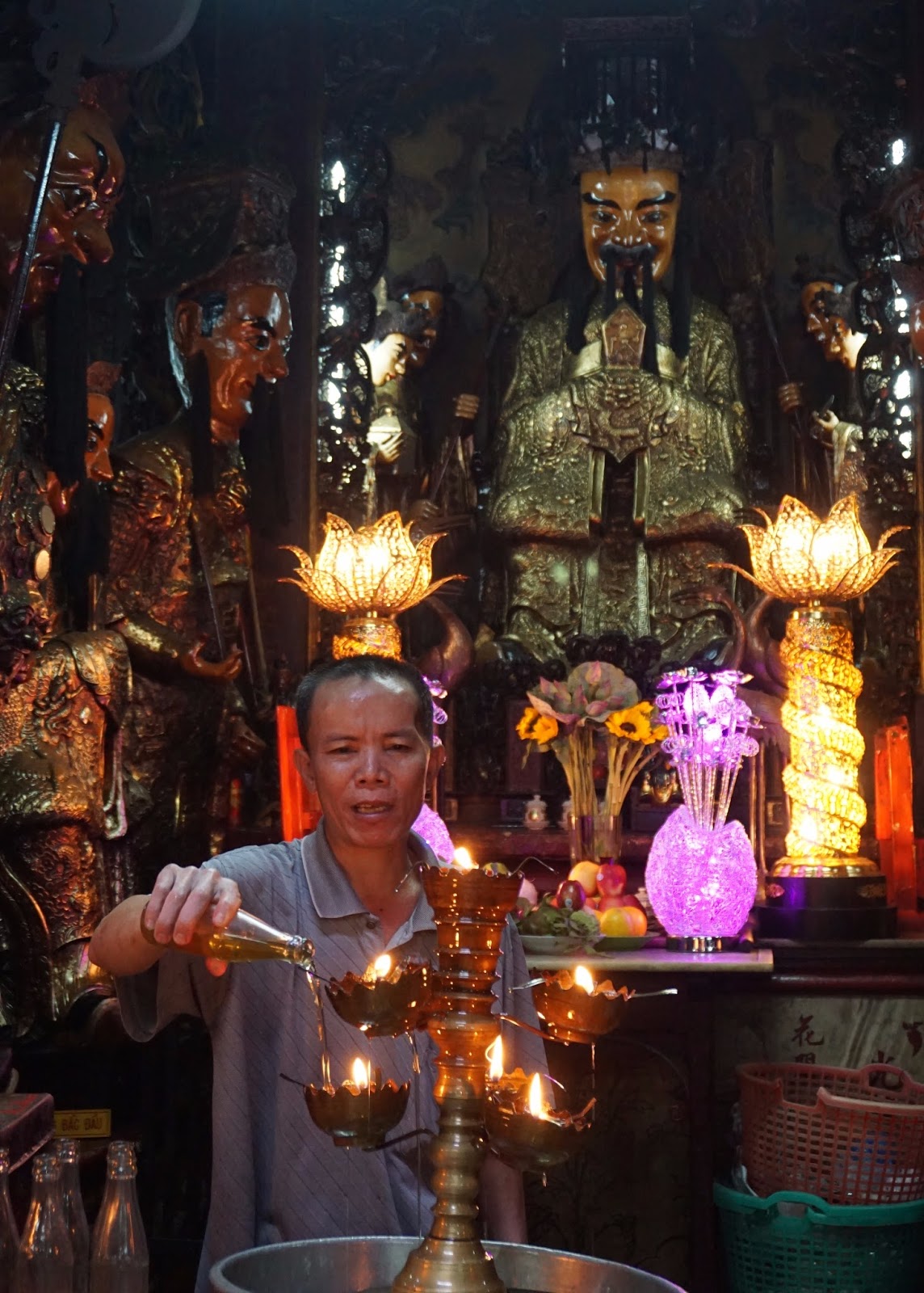
We also stopped at the Jade Emperor Pagoda. This is a temple of Taoism, a philosophical religion of Chinese origin.  The incense laden sanctuary is filled with menacing, black mustachioed figures. Interestingly, on the walk in, turtles, fish, and birds are offered for sale.  They are bought and then released as an offering.
 

Back at the hotel, we dropped off our backpack, and then walked to the nearby Ben Thanh market. We only have 40 minutes before closing.  Like in India we are beginning to tire of Asian markets. The need to always bargain is draining and unenjoyable.

From the market we continue on to the Rex Hotel where we find a seat at the rooftop bar. This was a famous hangout of military officers and war correspondents during the War. Our table overlooks City Hall and a small park containing a statue of Ho Chi Minh. The weather is delightful and the view captivating. An hour later several of our travelling companions join us for dinner.

An Australian couple, sitting nearby, regale us about getting hit by a motorcycle while walking, and the horrifying conditions of the local hospital. Aimee and I look at each other and agree to take a cab home instead of walking.

Thursday, January 19, 2017

January 15, 2017

January 15, 2017


We are on the road early this morning.  Out of the hotel at 6am we transfer to the airport for our flight to Saigon, or now Ho Chi Minh City.  Arriving safely, and too early for our hotel check-in, we board our bus for a visit to the Museum of Traditional Vietnamese Medicine.  This was mostly a snoozer but it does reinforce that Asians are still incredibly into alternative herbal treatments.  The best part of the experience is the nice artwork on the walls and the collection of ancient artifacts.


Afterwards, we head to lunch at the Propaganda Bistro.  The food was excellent and the restaurant was decorated in colorful kitschy war propaganda themed artwork.  Aimee really liked the pomelo salad.


Our next stop was the Reunification Palace.  This is the renamed Presidential Palace of the South Vietnamese government and where the war ended when NVA tanks crashed the gates in April 1975.  We spent an hour touring it.  It felt like we were in a time-warp with all the 60’s decorations.


We then went to the War Remnants Museum.  This place is packed with people making it hard to read anything and do justice to the exhibits.  Formerly called the American War Crimes Museum, it gives the North Vietnamese perspective on the war with photos about Napalm, Agent Orange, massacres, and carpet bombing.  Obviously one-sided, it does a good reinforcing that war is hell and we should have pulled out long before we did.  An army veteran friend explains it with the phrase, “we got in it for all the right reasons and stayed for all the wrong ones.”
.
After this sobering experience we did a short walking tour to what is left of some of the old French colonial buildings in this now very modern city.  We started at Notre Dame Cathedral (which looks like the Paris version), then across the street to the Post Office designed by Eiffel, and then on to the Opera House.


After a long day we find our nearby hotel and check in to our high-rise accommodations. Aimee and I and another couple from the trip decide to go up to the rooftop bar on the 31st floor to enjoy the view and have a drink.  Finding it very romantic we stay and have dinner on an open-air balcony.  It feels like we have a private room since we are in a small nook and we are the only guests.  We share a half dozen Spanish Tapas dishes washed down with Saigon beer. Great way to end a long travel day.

Tuesday, January 17, 2017

January 14, 2017

January 14, 2017


In the middle ages, Vietnam fractured into fiefdoms and feudal warfare. In 1802 an emperor emerged that united the whole country for the first time as it exists today. He moved the capital here to Hue in the middle of the country and built a fortified citadel. His subsequent Nguyen Dynasty did extensive construction. This Hue complex of monuments is now a World Heritage Site.


We started the day with a cruise on the local Perfume River in a modern Dragon boat. As with many of our tours, the operators have items for sale on the side. This cruise turned into a shopping spree after I modeled a bright red silk-like robe for our fellow passengers. Despite starting it, Aimee and I didn’t buy anything.


Just west of the city we dock at Thien Mu Pagoda (Heavenly Lady Pagoda) atop a small hill. This Buddhist temple built in 1601 is the oldest in Hue. Its most visible structure is a 7-story stupa. This temple was also a hotbed of activist anti-colonial monks, one of whom famously immolated himself in 1963.


Apparently this temple is also a monk training center as we see many young boys in robes and tonsured haircuts. While one is beating a gong in the temple, the rest have cleaning duty.


Back on the bus, we drive south of Hue to visit two tombs from the Nguyen dynasty. The first, the Tomb of Minh Mang, built around 1826, is a large complex of gardens, Oriental gates, bridges, Koi ponds, and temples. It is very picturesque and serene.


The second tomb, of Khai Dinh, was totally different. It is built on the side of a steep hill. We climb dragon stairs, past a series of terraces with stone guards, to the mausoleum.  It was magnificent, containing several rooms completely covered in brightly colored mosaics. Looking closer we see the mosaic consists of broken ceramics.


Back in Hue we had lunch, another set menu arranged by our guide. This set menu is a good way for us to sample different varieties of the local cuisine. This time we had Banh Khoai, which turned out to be a Viet form of tacos. And Bun Bo, which was some form of rice paste with a topping.  And we had noodle soup, which is a favorite of Asians.


After lunch, we drove to the Citadel of Hue as it begins to mist. While cloudy the whole trip, so far we have managed to avoid any precipitation. It finally caught up to us. Hue has a reputation for having the worst weather in Vietnam.


Hue Citadel is an enormous walled and moated city. Inside, close to the river is the Imperial City, another walled compound based on the Forbidden City of Beijing. Sadly, it was another victim of the Vietnam War. During the Tet Offensive of 1968, the North Vietnam Army occupied Hue Citadel for several weeks. In the ensuing battle to recapture the town, the Imperial City was pummeled in house-to-house fighting.


Our guide gave us a tour of the few remaining structures. It must have been magnificent.

Our group hires some Bicycle Rickshaws to pedal us around some farther reaches of the Citadel. It sure beats walking around this gigantic walled city.
Newer Posts Older Posts