Monday, July 02, 2012

June 28, 2012

June 28, 2012
Now that we are a little more acclimated to the altitude, we did the six-mile West Basin trail. This hike passed through a Quaking Aspen forest accented with Fir trees. It was nice except for the mosquitoes. They weren’t Minnesota thick but compared to Tucson they were swarming. Since the terrain was pretty flat we tried to hike fast and outrun them. We need to remember the insect repellant tomorrow.
The West Basin trail ends at the edge of the Mesa at the top of the Powderhorn ski hill.  Looking down the chair lift line we get a great view of the valley below. It seems the resort manager knew we were coming and left a couple Adirondack chairs at the top for us to rest on. We eat some snacks while watching a group of mechanics perform maintenance on the lift gear.

Sunday, July 01, 2012

June 27, 2012

June 27, 2012

Aimee is thinking we should stay here a while in Grand Mesa, Colorado. This place seems to be a great oasis from the heat wave scorching much of the West right now. Plus I like the economics. The electric sites here are dirt-cheap. The cash Aimee and I made working the last election will pay for three weeks of site fees here.

With no pressing sights to see we got up late today and Aimee fixed us a big breakfast. Midmorning we did a three-mile hike to explore the area. In that short span we passed a half dozen small lakes ending at Lost Lake. The shore seemed to be abuzz with mosquitoes. Oh no, our little paradise has a dark side. A fellow tourist said on the contrary, these were harmless Mayflies. He’s right; these flies aren’t biting and have no interest in us. I remember Mayflies from my flyfishing days. We would tie flies that looked like a Mayfly to attract trout. Now I see what they really look like.

Lost Lake is surrounded by steep boulder fields. I have seen these dark gray porous rocks often enough in the West to know they are basalt, formed from cooled lava. The description of the area as the largest flattop mountain is a euphemism for giant volcano. Oh Well, it is still beautiful and really what is the chance it blows again while we are here. Just in case, I am glad I always travel with Aimee, my lucky charm.

June 26, 2012

June 26, 2012

We would love to stay and do some more hiking in Canyonlands National Park and all the other great parks in southern Utah. Just not right now. It is too hot for strenuous outdoor activity. We need altitude to tame the heat. Colorado has mountains and is right next door. So we leave Moab headed north towards I-70. A few miles south of the interstate we make a short detour down a two-mile long dirt and rock road to a BLM Dinosaur Trackway site. About 500 feet up a rock hill are the first dinosaur tracks found in Utah. There are two sets of footprints. One is the elephant-like prints of a large plant-eating sauropod (think Brontosaurus). Parallel to it are the three-toed bird-like claw prints of its therapod predator, an Allosaurus, ancestor of the T-Rex. The tracks are interesting but they are very weathered. We have seen more distinct prints in other areas.
Back on the road, we hit I-70 and take it east into Colorado. I am disappointed. Colorado seems to just be a continuation of the cliffs and canyons of Utah. Where are those tall mountains I have read about? We meet up with the Colorado River, which is now just a large stream and follow it up river. It is still flowing inside a tall canyon. Looking at the map, I see some campgrounds clustered in Grand Mesa not far off the highway. We exit and drive uphill. Grand Mesa must be the transition from the desert mesas of Utah to Colorado’s mountains. Though flat like a mesa, it is high enough to have a pine forest on top. It bills itself as the largest flattop mountain in the world. We pass the ski resort of Powderhorn and at 10,000-foot elevation we pull into the first of several US forest service campgrounds in the area. It is wonderful. Our campsite is refreshingly cool, pine-forested, and a stones throw from a small lake.

June 25, 2012

June 25, 2012

The confluence of the Green and Colorado Rivers divides Canyonlands National Park into three distinct and separate areas. On our first visit, we explored the “Island in the Sky” section. We are excited to see what the “Needles” section has to offer. Despite getting little sleep last night we are up at dawn. In this heat we have to hike early or not at all. We start from the campground trailhead. A quarter mile in we realize that this starting point is going to add three miles to the journey. Too long at this temperature. We punt, return to the RV, and drive three miles down a dirt road to the Elephant Hill trailhead.

The hike to Chesler Park is stunning. This section of the park is almost all rock. Rock that has been eroded and weathered for eons. We climb up and down and around almost every imaginable rock formation. I am glad there are lots of cairns marking the trail, otherwise we would have been lost almost immediately. We are heading to the center of the “Needles”, a cluster of vertical pointed shafts of red rock. After climbing up and over the first Needle, we arrive at Chesler Park. It surprisingly turns out to really look like a park, a green rock-free patch of sage-brush desert surrounded by tall Needles.

Once back at the RV, we drive the scenic loop, do a couple roadside hikes, and then head out of the park and stop for the evening in Moab, UT. We are still hot, so after plugging in the AC, we head to the bathhouse and take the coldest shower possible. Aaaahhhh!

June 24, 2012

June 24, 2012

After leaving Navajo National Monument we stop in the nearby city of Kayenta, AZ. The local Burger King owner has set up a mini-museum on the Navajo “code talkers” to honor his father’s service in WWII. The military used a large group of the local Indians as radiomen speaking their native language to prevent the Japanese from eavesdropping on sensitive battlefield communications.


We drive northeast past Monument Valley into Utah. Since it is partly cloudy, we make a stop at Goosenecks State Park. We have been here before but I wasn’t pleased with the photos. I am hoping the clouds will give me a less washed-out shot of this winding San Juan River canyon. As we pull into the park, the clouds begin burning away. Darn! We continue on to the town of Blanding, UT and stop at Edge of the Cedars State Park. Closed on Sunday. We are just not having any luck today.

Undeterred, we take the exit for the “Needles” section of Canyonlands National Park and cross our fingers that there is an open campsite. It is 34 miles to the park along the base of a beautiful red rock canyon. Fortune is finally smiling today and there are lots of campsites to choose from. Later I question that fortitude. It seems the reason the campground is empty is because it is HOT and there is no electricity. To add insult, clouds roll in at dusk, trapping the desert heat. It is miserable sleeping weather, our worst by far in six years of traveling.

Tuesday, June 26, 2012

June 23, 2012

June 23, 2012

Navajo National Monument is a misnomer. The park happens to be on the Navajo Reservation, but it has nothing to do with them. The site celebrates the ancient pueblo Indians that lived here 800 years ago. The local Hopi are the likely descendents of these Anasazi; not the Navajo that migrated here in more recent times from Canada and displaced the locals.


While here we signed up for the guided hike down into the cliff dwelling. At 10am we meet up with four other hikers and follow a Navajo seasonal Ranger down a steep trail that descends to the canyon floor. Like much of the Colorado plateau, the canyon walls are red sandstone. We signed up for this hike not only because of the great scenery but also to reacclimate ourselves to the altitude and regain our hiking legs. It is a good thing because Aimee and I are really huffing and puffing on the uphill return.


The rest of the afternoon we relax under a pinon pine tree doing some reading. Aimee points out a gray squirrel scampering up our shade tree. A few minutes later the squirrel starts throwing stuff at us. I guess he doesn’t like us in his tree. I soon notice pieces of green pinecones everywhere. This fat squirrel is hungry! He is taking one cone after another and eating them voraciously like an ear of corn. Apparently he is after the pine nuts inside. Intrigued I pick a green cone too and peal away the outside. Inside I find a baker’s dozen of peanut-size pine nuts. We like pine nuts so Aimee and I both taste one but quickly spit them out. Either they are unripe or need to be roasted. Darn!

Monday, June 25, 2012

June 22, 2012

June 22, 2012

Having been kicked out of Flagstaff (at least for the weekend), we leave town headed northeast. We soon enter Navajo Nation, the largest Indian reservation in the US. It takes up the entire northeast corner of Arizona and is the size of West Virginia. We drive for a couple hours through pretty desolate territory. The first hour of terrain is National Park worthy, a cross between Painted Desert and Badlands. There is absolutely no vegetation, not even cacti. Still, the area is marked regularly with clusters of poorly maintained homes. Why anybody would live out here willingly is amazing. My guess is that the residents don’t get their government check if they leave the reservation.


After awhile the elevation rises back to 7000 feet and we enter pinon pine/juniper country. We make a left climbing up a hill of slick rock and enter Navajo National Monument. We have been here before but it makes a convenient stopping point. The campground is beautiful, uncrowded, and best of all, free. We make the short hike to the canyon overlook to view Betatakin, the Anasazi cliff dwelling that is the centerpiece of the park.

We return to the RV to relax, enjoy the scenery and do a little reading. The only annoyance is a gusting wind throwing dust around. I also get stung for the first time by a fire ant that was crawling on my toes. He got pinched underneath a sandal strap and bit to let me know he wasn’t happy. It hurt for a solid hour.

Friday, June 22, 2012

June 21, 2012

June 21, 2012


Summer came early this year and the heat has been relentless. Triple digits seem to be the norm. I am very torn on where to go this year. Normally I have a list of things I want to see. I guess my list at least in the West is getting pretty small, and the ones left are problematic. Still it is hot and we need to get out of here.

After loading the RV we get out of Tucson by midmorning. We make our first pit stop just south of the Gila River. That used to be the southern border of the US. With the Gadsen Purchase of 1853 we forced Mexico to sell us a strip of land (that includes Tucson) so the slave South could also build a rail line to California.

Past Phoenix we climbed up to the Colorado Plateau and stopped for the evening at a campground just south of Flagstaff. We are at 6600-foot elevation, in the pine trees. That is just high enough to get the temperature back to enjoyable. We aren’t alone. Apparently the Flagstaff area is popular with weekenders escaping the heat in Phoenix. We can only stay one night and we have to leave. Amazing, all 370 sites are booked this weekend.

Wednesday, May 23, 2012

May 21, 2012

May 21, 2012

The forecast today is for 105. Yes, it is a dry heat but it is still hot, especially in the sun. Cooler temperatures are in our backyard… sort of. Or at least I can see them atop the mountain we look at every day. Aimee and I jump in the car and make the ninety-minute journey to the summit of Mt. Lemmon. A drive up the steep Sky Island Scenic Byway with the A/C on full blast is apparently tough on the engine. Partway up I notice the car getting close to overheating, so I turn the air off before the radiator turns into a geyser. We don’t have to suffer long. The air temp steadily drops thirty degrees over the ascent to altitude 9157 feet. Near the top we stop to enjoy the pine smell and the great views of the valley far below, all while basking in the cool temperatures. Nestled in a narrow valley below the summit is the tiny hamlet of Summerhaven. It has a very apt name. It might be nice to have a summer cabin here, but there is precious little to do in this sky island but hike.

The summit of Mt. Lemmon is also home to the Steward Observatory. We meet a guide at the gate and follow him to the actual summit. There we see a half dozen telescope domes scattered around. None are gigantic. We later learn that one is controlled remotely by astronomers in South Korea. Because they are on the other side of the world, they can observe the night sky conveniently during their day.

We are here to attend the University of Arizona’s SkyNights program and it turns out to be simply outstanding. The five-hour program was well choreographed with non-stop action and learning. After a brief tour of the facilities, we were introduced to the star of the program, a 32-inch reflecting telescope. Aimee and I have looked through large amateur telescopes before and I have to say I have never been terribly impressed. The images are nothing like the photos, which are taken with hours and hours of camera exposure. This telescope though is professional size and completely computer controlled.  It reminded me of Robocop. The guide selected an object on the computer and the telescope moved into proper position. I want one! Our first view was the planet Venus and with this telescope it looks as large and crescent-shaped as the moon.

We next step out of the observatory to watch the setting sun. Because of a stray cloud it just happened to look like Saturn. We then had a great dinner waiting for the sky to darken. With our tummy’s full we return to the telescope and observe a star cluster, a double galaxy, a nebula, and the planet Mars.

We then take a break and walk outdoors for an orientation to the night sky and the constellations. Aimee learned how to use a star chart. We also watched a satellite pass thru the sky.
The climax of the night was a return to the observatory to see Saturn. That is always a treat no matter the telescope. With this one it was huge enough to see the separation in the rings. Aimee and I got in line to see it twice.

The only drawback of this wonderful evening of astronomy is getting home. It is a long drive back in the dark. Fortunately it is all downhill and we are the only ones on the winding road.

Friday, March 16, 2012

March 13, 2012

March 13, 2012

A few days ago the USA Today had an article on ten great places to see Spring wildflowers. One is just east of here in Anza-Borrego Desert State Park. So we leave San Diego and drive two hours up and over a lot of hills through ranch country that looks nothing like California. Eventually the mountains end and a vast desert stretches before us. The park Visitor Center is just below on the valley floor. There we learn that Anza-Borrego is the second largest state park in the United States. We also discover that the Gulf of California used to extend all the way up here. As the Grand Canyon was carved the resulting sand debris filled in this valley.

We decide to hike the six-mile Palm Canyon Trail. The hike follows a wash up a shallow canyon. I don’t see wildflowers anywhere. In fact, there is little of anything growing here including cactus. We come across several hikers staring at the top of the canyon. It is a Bighorn Sheep posing. Too bad I need binoculars to prove it is not a rock.


To our great surprise we eventually cross a tiny stream. Water in the desert. That is always a treat. And even more surprising, around the next bend we see palm trees in the distance! It is a real life desert oasis like seen in movies. Our first! And so very cool! On closer inspection it looks like a rock dam causes the water to pool here letting these California Fan Palms survive. This native palm is a descendent of the palms that grew here when this area was wetter and open to the sea. Interestingly the Mediterranean version of this fan palm decorates our pool at home.

From Anza-Borrego we head east. We run into the Salton Sea, the largest lake in California. This lake was formed accidentally in 1905 when flooding on the Colorado River overwhelmed the local irrigation canals and flooded the area. Because the area is below sea level, the water couldn’t be drained. Continuing east we cross Imperial Valley, a huge irrigated agricultural region that specializes in winter vegetables. We pass fields of carrots in various stages of harvest. As we drive east on I-8, I can see the border wall with Mexico. Shortly after crossing the Colorado River and the city of Yuma, AZ we hit desert again. We make it back to Tucson in time for Aimee’s bedtime. Unpacking can wait till morning.

Wednesday, March 14, 2012

March 12, 2012

The San Diego Zoo is world renown, and since I enjoy photographing animals, we couldn’t leave the area without a visit. Unfortunately ticket prices are a budget-busting $42 each. Coming from St Louis I am used to zoos being free.

We arrived shortly after opening and randomly picked a direction to start. I was immediately amused with a flock of Caribbean pink flamingos that would regularly honk and start marching in unison. We wandered into the monkey area and smiled again watching two gibbons compete on who could howl the loudest. We watched some chimpanzee-like bonobos use a stick as a tool to gather some gooey treat. Frustration soon set in because the Primate area is a maze of hilly intersecting paths making an efficient visit impossible. We walked around and around and never passed the gorillas or orangutans. I almost wish I had brought a highlighter so I could mark off the routes as we walk them.

We decided to push on to new areas and use the aerial tram to return to the entrance. We did a lot of walking, more than a normal zoo. Half the park seems to be non-zoo stuff, like shops, restaurants, entertainment, and roads, lots of roads. For the sedentary, the zoo offers a tour bus that will drive you around and let you “glance” at the animals from the comfort of your seat. The zoo seems to be conflicted on whether they want to be a walking zoo or a driving one. After three circuits of the park we thought we finally saw everything, so we hopped on the tour bus to give our weary feet a rest. To my consternation we missed at least one whole street.

In the end, the zoo was nice and awesomely landscaped with plants and flowers from around the world. And like all zoos, it has some unique exhibits but I am not sure if San Diego is any better than its major competitors. Interestingly the zoo also has a sister park outside town called Safari Park (for another $42) where the animals roam in an open savannah.

Weary and starving, we drove downtown and had an early dinner in the Gaslamp Quarter. We then crossed over to Coronado Island to visit the Hotel del Coronado. This historic structure opened in 1888. You may recognize it from when the hotel starred with Tony Curtis and Marilyn Monroe in the movie, “Some like it hot”. We make it back to Old Town in time for happy hour.

March 11, 2012

March 11, 2012

From San Clemente, we drove down the California coast to San Diego. Our first stop was a spit of land called Point Loma that houses the Cabrillo National Monument. Juan Rodriguez Cabrillo was a member of Hernando Cortez’s army that conquered the Aztecs. At that time, the American West was a big blank spot on the map. So in 1540 Coronado was sent by land to explore our Southwest, while Cabrillo sailed up the coast. Cabrillo discovered San Diego. He died later in the voyage and may have been buried on the Channel Island we visited last summer. The National Monument commemorates this first exploration of our west coast by Europeans.

After lunch we drove through heavy traffic to Old Town San Diego State Historic Park. Billed as the birthplace of California, Old Town is where the first Europeans settled. The Park is an easy mix of historic buildings, small museums and lots of shops and restaurants. It is very nice and seems to be where the locals go for dinner. After lazily walking the compact area, we stumble upon the adjacent Mormon Battalion Historic Site. We join a tour and quickly realize this is run by the Church. Aimee thinks it is a little hokey but aside from the soft-sell, I enjoy it. The tour is well done and I learn a little known historical tidbit. Near the end of the Mexican War, a group of 500 Mormons were recruited in Iowa to bolster the army in California. This battalion marched overland to San Diego but arrived too late. Their only fighting was against a herd of angry cattle.

Monday, March 12, 2012

March 10, 2012

March 10, 2012

This morning we drove over the San Gabriel mountains into Los Angeles. We arrived too early so we decided to stop at Grauman’s Chinese Theater to see the footprints in the cement that I remember from my childhood visit. I remember thinking at the time that only Shirley Temple’s prints were near my size. While walking to the Theater we also stumbled upon the “Walk of Fame” lining Hollywood Boulevard. Almost every actor and singer has a star embedded in the sidewalk. Also next door to Grauman’s is Kodak Theater. We stop and take a picture of where movie stars meet to give each other Oscar statues.

After this brief dalliance with Hollywood glitz we head to the very urban Hancock Park. This park contains the La Brea Tar Pits, where Ice Age mammals got stuck in gooey asphalt. What I thought was an historical artifact is still very active. Asphalt still seeps up in many spots in the grass. An oily sheen and smelly methane bubbles emanate from the park’s pond. La Brea also continues to be an active dig site with a seemingly endless supply of fossils. In the center of the park is the Page Museum displaying a tiny fraction of the fossils. They have found lots of almost every animal from the Ice Age. Dire Wolves and Saber-toothed cats have been found in the thousands. Scientists think these extinct carnivores just couldn’t resist pouncing on a struggling mammoth or buffalo. They even have found 400 Golden Eagles. No other spot matches the sheer concentration of fossils found at La Brea.

After lunch we drove north to Griffith Park. Griffith is the Central Park of Los Angeles. It sits on a beautiful hill overlooking LA. We wound our way up the narrow road packed with cars parked alongside. Griffith is a magnet for both tourists and locals. At the peak we stop at the observatory made famous in James Dean’s movie, Rebel without a Cause. From the deck we get a great view of the Hollywood sign and the city. We spend an hour perusing the Observatory's extensive exhibits on astronomy.

Aimee has been very patient with my touring. She wants payback now, so we drive to the Fashion district near downtown LA. It is a zoo of humanity. I drop Aimee off while I go looking for a spot to park. Aimee is in heaven. Here fabric is not sold by the yard, but by the pound!

The crowds of Los Angeles are getting to me, so we decide to cut short our tour and head southeast out of town. We spend the night in San Clemente, where Nixon had his western White House.

Saturday, March 10, 2012

March 9, 2012

March 9, 2012

After waking early from our camp in Death Valley, we find that Furnace Creek is less than a mile away. Death Valley sure is a place of extremes and contrast. This is the driest place in North America but here at Furnace Creek they have hundreds of water guzzling palm trees and a golf course! It is also the lowest and hottest point but very tall snow-capped mountains surround us. Death Valley is a desert but yet abounds in color.

After wishing we had brought our golf clubs, we stop at the Visitor Center, where we find no exhibits but a good movie. From there we stop just north at the ruins of the Harmony Borax Works. Enterprising chemists scraped this “white gold” off the top of the saltpan and purified it in a small chemical plant. Pretty amazing for the 1870’s. They then loaded the Borax into wagons and hauled them to the railhead on “Twenty-Mule Teams” made famous in TV commercials from my youth.

We finished our tour of Death Valley strolling a boardwalk over a spring-fed salt marsh and hiking a short way into a sand dune area. Our final stop was a hike of Mosaic canyon. The trailhead was reached by a steep drive up a two-mile gravel road. It was well worth it as this hike is a showcase of geology. The walls of this slot canyon are water-polished white marble. Clearly when rain does fall in this desert, the ensuing flash flood sculpts the scenery.

The whole day Aimee and I have been debating if we should spend another day here to see the “Racetrack”. This is a famous spot where boulders mysteriously move across a flat plain. Unfortunately we would need to rent a jeep and drive five hours along a very bumpy road. Aimee thinks that is crazy. We decide to save it for another day.

Instead we leave Death Valley and head towards Los Angeles. Along the way we stop at a rest stop in the small town of Trona. There we read some Interpretative signs about the local industry and terrain. During the Ice Age, lakes not only covered Death Valley but also a dozen other spots east of the Sierra Nevadas. Most are now dry or nearly dry lakebeds. Searles Lake here at Trona turned out to be a chemical gold mine. A modern chemical plant pumps up brine from deep below and finishes Mother Natures work producing Borax, Soda Ash, and Lithium.

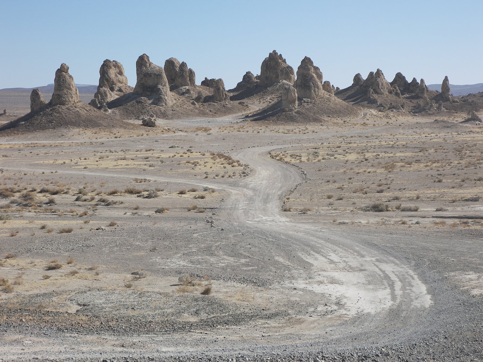
In the distance we can also see Trona Pinnacles National Landmark. Like everything today it is at the end of a long gravel road. I hope our tires last. The Pinnacles are a most unusual geologic feature, formed when Searles Lake was much deeper. They are made of Tufa limestone when Calcium-rich spring waters bubbled up into the highly alkaline lake water causing Lime to precipitate. These tall spires are otherworldly having starred in several science fiction movies like Planet of the Apes and Lost in Space.

We spent the night in Palmdale CA and had a wonderful Thai dinner.

March 8, 2012

March 8, 2012

Las Vegas is not our destination, just a convenient stopover point. Before heading out of town, we stopped at a local pawnshop near the Strip. No, we are not here to get some quick cash but to visit one of my favorite TV shows, “Pawn Stars”. Since our bodies are still on Mountain Time, we arrived too early. But it was a good thing we were early, because by 9AM there was a long line behind us. Over 4000 people visit every day. The inside is a lot smaller than it looks on TV. It is also packed. For filming they need to clear the entire place of customers and employees. Sadly the four main characters were nowhere to be seen.

From Vegas we drive two hours to Death Valley National Park across the border in California. Once in the park, we make a detour to Dantes View. This spot at 5000-foot elevation gives a great overview of the park. Below us we can see the long Death Valley with its white saltpan floor surrounded by very high mountains.

From Dante we drive farther into the park amazed how mountainous and colorful the terrain is. There is obvious black volcanic formations mixed with whitish gold sedimentary rocks. We drive downhill and make a left onto Badwater Road. This path follows the saltpan down to its lowest point at 282 feet below sea level. We get lucky and arrive just in time for an excellent ranger-guided walking tour. During the Ice Age, a lake filled Death Valley. It has since evaporated leaving all the salts behind. Even though Death Valley is the driest point in North America, it isn’t dry. Natural Springs flow underground into the valley. The water table is only a few inches below the surface. The constant churn of water is like a little natural chemical factory separating all the minerals eroding out of the surrounding mountains.

On the way out of Badwater Basin, we make a short detour along Artists Drive up into the side canyons lining the salt flat. Here we get close up looks at the spectrum of colors that result from Mother Nature’s chemical separation process. We also stop at Golden Canyon for a short hike up an eroded mudstone canyon the color of whitish gold.

Since we are in a National Park without the RV, we tent camped. Oh how we miss our motorhome. No running water, no lights, no comfy bed, and no cold beer.

Wednesday, March 07, 2012

March 7, 2012

March 7, 2012

This is the time of the year when the IRS makes me do a lot of extra work. It is a very taxing effort, so I convinced Aimee I need a vacation. We left this morning for the long drive to the opposite corner of Arizona. In Phoenix we caught the Joshua Tree Parkway headed northwest through one of the more isolated parts of Arizona. About halfway along we ran into the Joshua forest. Since these strange trees are native to the Mojave Desert of California, I wasn’t expecting to see many here. Surprisingly there were thousands. Joshua Tree National Park has nothing over Arizona.

After driving another couple hours we made it to the border. When we hit the Welcome to Nevada sign, I asked Aimee what happened to Hoover Dam? On our last trip through we watched them building a beautiful suspension bridge as a bypass around the dam. Apparently they built high concrete sides on the bridge deck to prevent gawkers like me from slowing down to take pictures. We crossed the new bridge and didn’t realize it. On the Nevada side we took the first exit and wound our way back to the bridge. A short hike brought us onto a pedestrian crossing of the bridge. It provides a great view of Hoover Dam but from this vantage it looks smaller and less impressive.

A short drive later we arrived in Las Vegas where we spent the night at a casino hotel.

Monday, January 02, 2012

December 30-31, 2011

December 30-31, 2011

This morning we continued west taking a detour near Santa Fe to visit Kasha Katuwe Tent Rocks National Monument. This BLM-managed site was established in 2001 by Bill Clinton. Since it is new I am not expecting much. I thought it would be a good excuse for some exercise. As we drive closer, I am getting a little worried by all the snow we are passing; plus the temperature has yet to climb above freezing. I am thinking we should come back in the summer.

The monument terrain is composed of layers of ash and mud deposited from volcanic eruptions that have been common in New Mexico’s geologic history. Our hike takes us up the eroded edge of this ash bed. It turns out to be wonderful, and a two-fer nonetheless. The first part of the four-mile roundtrip is up a slot canyon that was much narrower than I expected. In many spots it was only body-width. The canyon was beautiful against the white snow and blue sky. This is one of the few real hikes we have taken in wintry conditions.

The second part was at the mesa top and was totally different. Here teepee-shaped formations abound. Apparently the volcanic ash part of the ground is easily eroded. But when the force of erosion encountered a resistant boulder or rock, the earth below was protected leaving behind these conical shapes. Very Cool!

The downside of hiking in winter is getting back down the cliff. This National Monument turned out to be very popular and between the sun and many footsteps the snow is now packed ice. Our descent is treacherous with both of us slipping several times. Aimee says I just missed hitting my head on a rock by an inch.

Normally on our way from Amarillo to Tucson we take the short cut across the mountains of New Mexico. This time we decided to follow the all-interstate route. I-25 follows the El Camino Real National Historic Trail. El Camino Real (Royal Road) was a Spanish trade route that connected Mexico City with Santa Fe. In New Mexico the trail follows the Rio Grande River. It was used starting in 1598 for almost 300 years until a rail line was laid atop of it.

South of Socorro, we arrive at the El Camino Real Heritage Center. Unfortunately we got there an hour before closing because Aimee made us stop at a quilt store on the way. We had to make a mad dash through the museum before it closed.

We continued following the trail south but didn’t make it very far before sunset. We spent the night in Truth or Consequences, NM. This town was originally named Hot Springs but changed its name in response to a contest offered by the game show. On the way out of town the next morning we noticed hot springs steaming in the distance.

On this long drive back to Tucson we have been listening to a linguistics course we did a few years ago. It is just as interesting as the first time. It is fascinating to see how all languages change dramatically over time. In the absence of writing to “freeze” pronunciation, people make lazy shortcuts. For example, you can easily see how the English word “nothing” could evolve into “nuthin”, then "nutin" and “nudin”, and likely “nud” in only a few generations. This is how Latin slowly and naturally evolved into Italian in Italy.

Thursday, December 29, 2011

December 29, 2011

December 29, 2011

We are on our way back to Tucson. The Midwest is having an unseasonal warm spell. We take advantage of it and visit Chickasaw National Recreation Area in south central Oklahoma. Our first stop is at the Travertine Nature Center to watch the short movie and peruse some exhibits. Aimee is glued to a tank of apparently amorous swimming turtles. The focus of the park was 33 natural springs that became popular years ago for their apparent therapeutic waters. To protect them, the local Choctaw and Chickasaw Indians sold the property to the Federal government who turned this nature reserve into Platt National Park in 1906. Since then, the appeal of water springs has waned and drought has dried up most of the springs. The springs were combined with an adjacent lake and demoted now to just a recreation area.

From the nature center we take a very pleasant stroll along Travertine Creek to two of the remaining springs. They are barely flowing. No problem, it is warm and sunny. After taking a quick drive around another part of the park, we head out and spend the night in Tucumcari, NM.

Friday, December 23, 2011

December 21, 2011

December 21, 2011

We are in day three of our annual drive back to the Midwest for Christmas. A snowstorm blew through Amarillo so we opted for the warmer, but longer, southern route through the heart of Texas. That means we drove past Memphis this morning. Aimee and I haven’t been to Memphis for many years so we combined our need for a break with my desire for a little exploration. We first stopped at the National Civil Rights Museum. It is housed in a new building built adjoining the old Lorraine Motel. This oft-photographed motel was where Martin Luther King was assassinated. Aimee instantly recognized the small two-story facade when we pulled in the parking lot.

The museum is kind of a two-fer. The main building houses a museum chronicling the black struggle for civil equality. It is well done and interesting. Martin Luther King’s name is mentioned in almost every panel because he was the primary organizer of the series of boycotts, sit-ins and demonstrations throughout the Jim Crow South during the first half of the 20th century. King modeled his strategy on the non-violent actions of Mohandas Gandhi that helped win independence for India. It was sad to see how violent the reaction of the White South was. The history lesson ends on April 4, 1968 in the motel’s Room 306, and its now infamous balcony.

The second part of the museum is across the street in the old boarding house from where James Earl Ray made the fatal rifle shot. This building is devoted to the crime scene and is eerily reminiscent of the School Book Depository Museum on Dealey Plaza in Dallas, TX. There is even a significant section on the possible conspiracy theories with this assassination also.

At noontime we drove over to Mud Island to have lunch. This city park on an island in the river has a half-mile long model of the lower Mississippi. We saw it on our first trip to Memphis fourteen years ago and I thought it was very cool. Unfortunately it is closed for the season. So we punt and head for my hometown of Godfrey, IL. On the way I realize we are going to pass by Mastodon State Park in Kimmswick, MO. We reach it shortly before dusk and make a quick hike around its bone bed trail. Although scenic it is uninspiring. Plus the museum is closed and only open on weekends in winter. We learned about this historic site when we visited Clovis, NM this summer. Like Clovis, archeologists found Indian arrowheads here embedded inside extinct Megafauna fossils proving man migrated to North America at least 12,000 years ago. "Clovis point" arrowheads would be known instead as “Kimmswick” points if the local archeologist who made the discovery around 1900 had documented the discovery better.

Saturday, September 10, 2011

September 6, 2011

September 6, 2011

We are on the west side of Los Angeles and need to go east to return to Tucson. Amazingly it is a two-hour drive just to cross the LA metro area. And that is going the speed limit! With LA’s notorious traffic it could be an all day journey, not to mention that the RV is a scary ride in heavy traffic. So Aimee shouldn’t have been surprised when I woke her at 4:30AM and told her we were leaving. She didn’t think I could wake up that early.

On the road before 5am I was shocked to find the highways weren’t empty. With all the cars I see during the day, I often think nobody works anymore. It is nice to know that some people actually get up early and still go to work.

We made it to Yorba Linda, CA on the east side around 7am. We took showers and caught up on emails till 10am when the Richard Nixon Presidential Library and Museum opened. It is a beautiful place, well manicured and richly decorated. I guess I had the impression a disgraced presidency wouldn’t have attracted this much money. The library was built on the site of Nixon’s birthplace and family orchard. The original house is still on the grounds.

The museum was outstanding, part autobiography but mainly an in depth history book on the 50’s and 60’s. It really is too much to see in one day. I could easily come back. I am glad we saw Reagan’s Library recently. These two make a marked contrast. Even though both were Republicans from California, their presidencies were exact opposites. Reagan’s persona and message was uplifting, he had a successful presidency, he revitalized the country, and in his campaign terms, “it was a new day”. Nixon on the other hand, was our worst day.

The section on Watergate is surprisingly candid. It was recently redone by the National Archives, who took over the library a few years ago. It is obvious Nixon was a paranoid guy who saw conspiracy everywhere. In some ways he was justified, since it is likely his 1960 presidency was stolen by Chicago (Daley) voting fraud. But I am a big believer in character. We don’t vote directly on issues. We have a representative government. We depend on that elector to use his best judgment in making decisions. If we elect a lying crook looking out for his own benefit, we the people lose. Unfortunately as a country, we continue to reelect crooks election after election and then wonder why we have problems.

In the early afternoon, we left Yorba Linda heading east back to Tucson. It doesn’t take long to hit desert. In Palm Springs we saw what has to be the worlds largest wind farm. Thousands line both sides of the highway. In our travels we have seen wind farms popping up everywhere. What I am always in consternation about is the high percentage of non-spinners. Maintenance is a big issue. They are put up for the tax benefit but since they are uneconomical on their own, they are not worth fixing when they break. That is the dirty secret of subsidized programs. I estimate half of Palm Springs’ windmills sit idle.

We spent the night in Quartzite, AZ home of a massive RV show. Not now, but in January. Currently it is hot hot hot!

September 5, 2011

September 5, 2011

From Simi Valley, CA we drove next door to the Visitor Center for Santa Monica Mountains National Recreation Area. This NRA encompasses the whole coastal mountain range west of LA and is a hodgepodge of various state, national and local parks.

We have a time crunch so we decide to do mostly a driving tour. We stop first at Paramount Ranch. This is an old studio property that the National Park now owns. The Santa Monica Mountains have been the backdrop for countless movies. We walk around an old western set that is looking pretty shabby. The surrounding hills look, for good reason, like the mountains in the TV show MASH.

We then drove south along Malibu Canyon to the ocean. There we followed the Pacific Coast Highway past the Malibu coastline. It is beautiful but crowded. We finished at the harbor in Oxnard.

At 1:30 we caught a boat to Channel Islands National Park. This park consists of several islands just off the coast. We chose to be dropped off at Anacapa, the closest and smallest of the group. It takes an hour for this slow barge to traverse the ten miles. It was also a bumpy ride. We forgot the Dramamine. Aimee and I both looked at each other wondering who would get sick first.

Anacapa is a five-mile long spine of rock jutting out of the ocean. Sheer cliffs completely surround it. Isolated from California, different and unusual plants grow here. We hike to each end.

Most of the rocky island is completely covered with a carpet of ice plants, a fleshy groundcover with pretty flowers. There is also a strange kind of stunted tree called coreopsis that looks dead but is really just hibernating till the next rainfall. The one negative is the stench. It is a major breeding ground for pelicans and sea gulls.

Our return trip to shore is packed, overloaded in my mind. We added a dozen people who camped overnight, all their gear, and six large kayaks. Looking for a smoother ride, we got seats at the stern.

Thursday, September 08, 2011

September 4, 2011

September 4, 2011

This morning we drove into the Los Angeles metro area stopping in Simi Valley. There we found Ronald Reagan’s Presidential Library and Museum. I have to say it was very moving listening to Ron again. His message was always upbeat and stirring. I found the museum to be very good, even though we moved through it quickly. We lived this era and know the history well. Incredibly the museum is built around an entire Air Force One jet. I have no idea how they got it on top of this hill.

It almost seems déjà vu listening to Ron speak. Running for governor of California he talked about the poor economy and persistent budget deficits. He solved the state problems. Later running for president, he talked about the ailing US economy. He fixed those problems too. California and the US are in similar straits today. Who is the new Ronnie that is going to save us this time? We might have an inkling if we stay. The Republican Presidential Debate is being held here in a couple days. They asked me to stay and say a few words.

Through one of our RV guidebooks we found a park in Simi Valley just down the road from the library. It is surprisingly empty for a holiday. It is a gem, a small county park hidden away, with no recreational facilities that would lure the locals.

September 3, 2011

September 3, 2011

We drove again all day, south through California’s central valley past more orchards and tomato farms. California is an immense state. Finally north of Los Angeles we climb out of the valley and stay at the only campground we could find with availability. This is Labor Day weekend. I have grown to dislike holidays. It causes difficulty finding a place to stay. We have to stay far out of town and contend with holiday rates.

September 2, 2011

September 2, 2011

August is history and northern nights are turning cold. That is our signal to turn around and head south. We return to California and descend back into the Sacramento Valley. As we drive for many hours, I still can’t believe the number of orchard trees we pass. They are seemingly endless.

The highway (I-5) is in terrible condition. California is broke and probably can’t repave it. It’s amusing to see all the tomatoes on the side of the road, apparently bumped out of trucks by the potholes. I thought about stopping but Aimee nixed the plan. She is not cooking California “road kill”.

We spent the night at a nice county park on the bank of the San Joaquin River.

September 1, 2011

September 1, 2011

Last night we drove to Ashland, OR. It has great summer weather, beautiful scenery, and is home to a Shakespeare festival. So after dinner we drove in to town and saw Love’s Labor Lost in an outdoor Shakespearean theater. The play was so-so but the actors were great.

From Ashland we drove west to Oregon Caves National Monument. The last ten miles was up a very windy cliff road. When we arrived we were immediately questioned again about bat disease and visiting eastern caves. We got a reprieve after saying we had been recently disinfected. We were then allowed to walk to the Visitor Center, where we bought tour tickets.

Given a choice, Aimee much prefers these group tours through lighted caves. I am not so impressed however. To me Oregon Caves is very ordinary and not much different than the other thousand caves throughout the country. Nevertheless it is a nice tour. I was randomly flashing my light on the various formations, when by accident I found the most interesting thing for me. A piece of historical graffiti dated 1877 from before it was named a national monument.

After hiking uphill on the cave tour, we return to the Visitor Center via a nice stroll thru the forest that gives us nice views of the valley we drove up.
Newer Posts Older Posts