Saturday, December 10, 2022

December 6, 2022

December 6, 2022

We checked out and left Turangi, New Zealand heading north. The road follows the eastern shore of Lake Taupo. The large lake is the water-filled caldera of an ancient supervolcano. Just past the town of Taupo, we follow the Waikato River downstream and stop for a walk to Huka Falls. Here the wide river is forced through a hard volcanic gorge. The water is swirling and so blue from the minerals and bubbles.

Nearby we can see steam rising. This area is full of geothermal activity. We drive around the nearby Wairakei Power Plant. It has miles of piping that use superheated groundwater to drive electric turbines. Unfortunately they no longer do tours.

We continued our drive north along the Thermal Explorer Highway. We stop and do a short hike at the Rainbow Mountain Scenic Reserve. This colorful mountain is actually the side of a volcanic crater that is stained colors because of leaching minerals. There is a small blue lake at the crater bottom.

Only a couple miles away is Waimangu Volcanic Valley. We have lunch at their cafe before touring the park. A century ago it was the biggest draw in New Zealand because it had the world’s largest geyser and a beautiful set of hot spring terraces. Sadly these were lost because of the 1886 eruption of nearby Mt Tarawera. The park is ideal for weary hikers because it is mostly a downhill valley walk with return via a shuttle bus. The initial attractions are a couple large steaming lakes followed by an overflow stream. The small stream has colorful banks of stained silica formed from hot water percolating from the adjacent hillside.

Farther along the trail are several hot water terraces with ponds growing algae. The hot water allows different strains of colorful algae to form. I like the almost modern art look of this natural formation. This park is only mildly interesting to us. Once you have seen Yellowstone, which contains half of all the world's geothermal features, everywhere else pales in comparison.

The stream empties into a lake with Mt Tarawera in the background. Aimee and I decide not to take the boat tour of the lake where the historic Terraces once stood. Waiting for the return shuttle, we enjoy watching the many Black Swans on the lake. All of a sudden a chorus of croaking erupts from the lakeshore. It is very bassy and deep-throated. It has to be some monster frogs. Aimee and I scan the shoreline but cannot locate any of the dozens of voices. And then almost on cue, they all stop. This happens several times. Finally the bus driver arrives and he points out the culprits. Tiny green Australian Bell frogs with big voices!

Back at our starting point, we continue the drive north through mostly rural farmland. We make a stop along the way to photograph a pretty flowering tree, then we have to stop again to let a mother Magpie Duck with several ducklings cross the road. We end our day in the city of Rotorua.

Friday, December 09, 2022

December 5, 2022

December 5, 2022

This morning we returned to explore more of Tongariro National Park. The park encompasses a cluster of active volcanoes. We climbed the perimeter of conical Mt. Ngauruhoe yesterday. To its south is the higher snow-capped Mt Ruapehi. We park and hike the Taranaki Falls Walk. This circular trail traverses the alpine saddle between these two peaks.

It takes an hour for us to reach Taranaki Falls. It is a picturesque waterfall that plunges from a window in the basalt cliff face. The hike ends near the historic Chateau Tongariro Hotel. We stopped in for lunch but were told that they are only serving guests because of staffing shortages. We have heard that all over New Zealand. To service the seasonal tourist trade, New Zealand relies heavily on international employees which are only just beginning to return after the long border closure.

The only place we found to eat lunch at this tiny outpost was from a food truck. We ordered a toasted ham and cheese 'sammie'. While eating I saw a bright red Cinnabar Moth flying around. Unlike most moths, it is a day-flier.

Our next stop was the National Park Visitor Center. Tongariro is the oldest in New Zealand, becoming a National Park in 1886, only fourteen years after Yellowstone. We watched the park film about volcanic activity in New Zealand. The North Island has lots of active volcanoes and has a long history of eruptions. In 1953, 151 people died in a train disaster when the volcano above us took out a bridge. Just three years ago, 21 tourists died when White Island erupted.

Based on a ranger recommendation we drove to the ski field several miles uphill from the Visitor Center. The landscape below the snow-capped peak is a barren moonscape of basalt lava. I assume it looks less hostile in the winter when blanketed in snow.

A few miles below the Visitor Center, we stopped to do the short hike out to Tawhai Falls. This scenic cascade is nicknamed Gollum's Pool because a scene from the Lord of the Rings was filmed here.

On the way back to Turangi, we stopped to hike around Lake Rotopounamu. We didn't count on the twenty minute uphill hike to reach it. Tired, we just walked a small bit of the perimeter. Surprisingly we heard more birds on this short hike than we have in all of New Zealand.

For dinner we had a pizza at the pub. It was our first mediocre meal.

December 4, 2022

December 4, 2022

We woke early this morning in the small town of Turangi. We are going to explore our last New Zealand Great Walk, the Tongariro Northern Circuit. We are hiking the most famous section, the Tongariro Alpine Crossing, often lauded as the best day hike in the country. Weather plays a crucial role, so I set aside two days in the schedule. The trail is often closed because of cold, wind, low visibility, or volcanic activity! Luckily the forecast for today was sunshine, so last night we quickly made a reservation for a shuttle transfer.

After gearing up, we drove twenty minutes to the Ketetahi Parking Lot near the finish of this one-way track. We couldn’t get a reservation in the parking lot so we just parked alongside the nearby highway. We are way early for our 8:30AM shuttle. Aimee sweet talks the bus driver and he makes room for us on the 7:30AM which is just leaving. This bus transfer takes us to the Mangatepopo Parking Lot at the start of the Crossing track. If everything works out we will end our 12.5 mile hike where we left our car at Ketetahi.

From the Mangatepopo road end, we began our trek just after 8AM. It is an easy stroll through a lava field. We are in Tongariro National Park which consists of the several volcanoes that make up the center of the North Island. The Park is also a World Heritage site. We reached the small waterfall of Soda Springs after an hour.

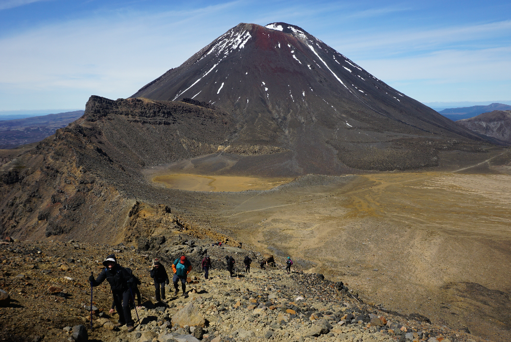
The track now climbs towards the volcano, Mt. Ngauruhoe. It is the picture perfect volcano. Cone-shaped, dark and still very active. It is also known as Mt Doom, because it played that role in the climax of the movie, Lord of the Rings. The filmmakers couldn’t have picked a better location. Aimee and I are feeling blessed during the ascent. We have blue skies and the weather is mild. I didn’t need to bring along all the emergency cold-weather clothing that the park recommends. We get nice views to the west, especially to Mt Egmont, on the far western shore. That volcano is the Mt Fuji of New Zealand.

It takes an hour of climbing to reach South Crater at the foot of Mt. Doom. We stop and have our first rest break and snacks. So far we are not overly impressed with this trail. A breeze picks up as we walk toward the Red Crater Ridge. The breeze is chilly but I don’t think it warrants adding any layers.

The track now ascends to the top of Red Crater, the high point of the Crossing. It is exposed so I figure it will get a little cooler and I add my raincoat as a windbreaker. After only a hundred yards the wind picks up to almost gale force and the wind chill drops precipitously. We have to stop in the shelter of a rock and put on every layer we have including winter gloves. We tighten the straps on our hats. It is a brutal hike up a loose rock field. We plow through and reach the top (elev. 6200 ft) in less than a half hour. Aimee said she saw one lady’s ball cap fly right off the cliff. I can’t imagine what this section would be like in bad weather. No wonder the park reinforces the weather alerts.

Almost as soon as we crest the top of the Red Crater and begin our descent, the wind dies and the temperature increases. The back side is one giant rock and gravel hill. Many people are finding it treacherous. I think it is a piece of cake, like running down a sand dune. Soon Aimee also learns to dig her heel in and she calms down. One side of the Red Crater is missing, exposing the bright red iron oxide of its center. It deserves its name.

The descent from Red Crater is interrupted to take photos of the Emerald Lakes that sit at the bottom. They are very picturesque in contrast with the gray and black volcano colors. In the distance is Blue Lake. These lakes are old explosion craters that have filled with mineral-rich water. We take our time and take lots of photos.

Since we are not yet halfway, we need to keep pushing on. Another half hour puts us across Central Crater to Blue Lake. It is large but loses it blue vibrancy up close.

I am not expecting much on this second half. I assume it is just a long walk back to the car. I am pleasantly surprised at the final crest to see a scenic vista with several large lakes in the distance.

The descent off the back of this volcanic mountain is long and winding. It doesn't help that I have to stop and take photos frequently. Besides the distant lakes, there is hissing steam in several directions. This backside also seems to have lots of native vegetation, especially large expanses of Red Tussock grass. I recently learned about this native grass at a conservation area in the South Island.

It takes hours but eventually we get below the alpine tussock region into some bushy alpine region. That gives way to forests. The descent is taking us through many biomes. This hike is not wanting to end. Stopping to take a photo occasionally takes my mind off of the marathon walk. Even when the official track does finally end at Ketetahi Road end, we have amost a mile down the road to where our car is parked on the highway. By the bottom my toes are hurting from all the downhill pounding. My personal GPS says we walked 14 miles compared to the 12.5 on the brochure. I have been long suspecting Kiwi miles were longer than ours!

Wednesday, December 07, 2022

December 3, 2022

December 3, 2022

Lying in bed, looking out my window last night, I saw stars again. I can’t believe how excited I now get for clear skies. I saw Orion again the first time up, but the second time the constellation Centaurus was center stage. Its super-bright star alpha-Centauri is our closest neighbor. I learned that as a child watching Lost in Space. After waking up, I was happy seeing a colorful sunrise. Aimee spoiled it when she announces that Air New Zealand cancelled our flight this morning from Queenstown to Auckland. Darn! Here we go again. We tried to book the one thirty minutes later but we were too slow. We got two of the last seats on a late morning flight.

We packed up and checked out and waited for the airport bus outside our hotel. The first never came. Almost an hour later one showed up. Today is not starting out so well. We made it to the airport and boarded our flight without issue. Immediately the baby in front of us screamed for the first ten minutes. Most of the people we have encountered in New Zealand seem to be young with children.

Our bad luck today seemed to end when we finally took off. The baby calmed down and we had clear skies for almost the first hour. We had great views of the glacial blue lakes we visited. The grandeur of the Southern Alps was before my eyes. I even saw a cloudless Mt Cook/Aoraki.

When we landed in Auckland, we took the shuttle to pick up our rental car. We got an unplanned upgrade but found the car has lots of quirks that took getting used to. Since we are late, we had to scuttle our tour plans and we instead drove four hours south to the town of Turangi in the center of the north island. We had a hamburger dinner at the local pub and then went shopping for snacks at the grocery next door.

Tuesday, December 06, 2022

December 2, 2022

December 2, 2022

We have a superb view of Milford Sound, New Zealand, from our room. I woke up in the middle of the night for a bathroom break and noticed the stars shining bright. That is a good harbinger for the day ahead. It also reminded me that if it was clear I intended to go out and see the night sky. I remember from Australia that the Southern Sky has 50% more bright stars. I am way too comfy under the sheets so instead I peer up and clearly see the constellation Orion staring down at me. Being in the southern hemisphere it is upside down of course. A few hours later, that same clear view and bright sunrise woke me up earlier than I wanted.

After a late breakfast we turned in our loaned hiking gear, checked out, and waited for the bus. Milford Sound is clear and calm and gives me the opportunity for some nice reflection photos. I am pretty sure that happens almost never. I am grateful for the good weather my lucky charm of a wife delivered on this hiking adventure.

While taking photos, of course Aimee and I heard that elusive songbird again in the trees. This time it swooped down right over our heads straight to some flowers on a nearby Maori Flax plant. I quickly pivoted and got some shots so we could identify it as the nectar-eating Korimak or New Zealand Bellbird.

We drove the few blocks to the marina and loaded on a tour boat for our excursion on Milford Sound. We have glorious sunshine. This probably only occurs once a month. The only downside of no rain is the waterfalls are minimal. Minimal for Fiordlands, that is. There are still a huge number from wispy to roaring. Milford is a sight to behold. No wonder tourists have been striving to come here under great duress and high expense for well over a century.

Back on dry land, we began the long drive back to Queenstown. The route takes us up the Cleddau Valley through the Homer Tunnel that connects us to the Hollyford Valley and over the Divide Pass into the Eglinton valley. This road only opened in 1953. We stopped in Te Anau to eat our sack lunch. And then it is another two hours to Queenstown. We lug our gear to our hotel in the plastic bag we used as a waterproof backpack liner. After checking emails at the hotel (with another nice view) we return to Pog Mahones for a Guinness and Soup. Along the way we met several of our new friends from the tour.

Monday, December 05, 2022

December 1, 2022

December 1, 2022

We awoke in Quintin Lodge on the Milford Track in New Zealand, had breakfast and made our sack lunch. We assembled outside as a group again. Just as we were leaving, a Kea, or Mountain Parrot, landed on the tin roof above our head. Their plumage is jungle green. Great camouflage. No wonder we couldn't spot it before. Keas are notorious for curiosity with their hard beaks. They will open backpacks and pry rubber parts off cars. We watched as the Kea checked every nail and screw on the lodge roof hoping to find something loose.

Not long after setting out we got a long distance view of Sutherland Falls. For me that is good enough. My ankles and toes are very thankful I didn't hike to see it yesterday afternoon.

Our last leg of the Milford Track is mostly flat but at 13.5 miles the longest yet. Thankfully the rain has mostly gone. The track follows the forest for much of the route. I can tell that rainfall is heavier in this more westerly valley. The Fern Trees have returned.

There are few vistas in the dense forest canopy. We get glimpses of the Arthur River that flows down the center of the valley. It is wide and has lakes along its length.

We don’t stop for lunch until after the ten mile mark. We eat on the rocks by the scenic Giant Gate waterfall. The one negative of sunshine and no rain in Fiordlands is Sandflies. They are the New Zealand equivalent of our mosquito. They swarm and bite, and insect repellent seems to have little effect. We sit as close to the water spray as possible to keep them at bay. At the same time we have to fend off a persistent Weka that investigates every backpack looking for food.

The last three miles seem to never end, but they finally do and we reach the 33.5-milepost marking our successful completion of the Milford Track at Sandfly Point.

We then wait for the small boat launch that ferries us the short distance across Milford Sound to our accommodations. We get lucky and the captain allows me to squeeze on with Aimee on the next transfer.

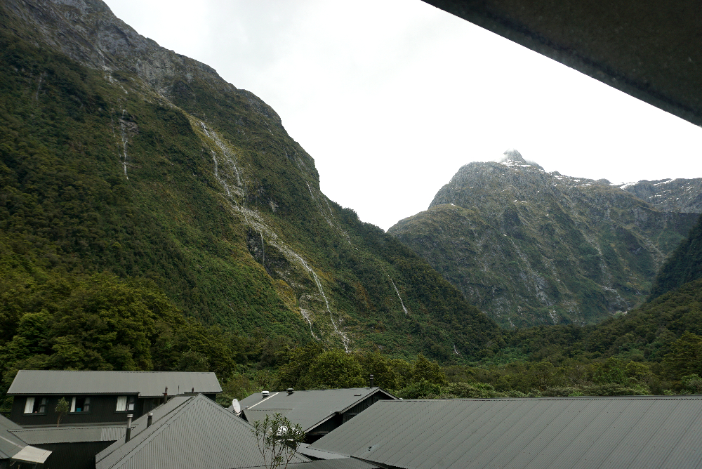
At Mitre Peak Lodge we have our best view yet out our room window. And we can see some blue sky! And the top of Mitre Peak is visible. That is a rarity in the rain forest. We also unpack the bag we sent ahead. It is nice to have clean clothes and comfy shoes. We have a celebratory drink at the bar which also has a nice view of Milford Sound.

At every lodge we had communal drying rooms. A couple people complained of missing items. At our last briefing this evening, one Australian was reunited with a pair of missing underwear. In true Aussie fashion he decided to prove to everyone in the room it was his by mooning us! 

Sunday, December 04, 2022

November 30, 2022

November 30, 2022

Of course it poured all night again, but we slept like babies. We were startled awake at Pompolona Lodge in Fiordlands National Park with our bed lights coming on with the generator start at 6AM. We have the routine down with a first stop at the coffee station, then breakfast, lunch preparation, before heading back to the room to restow everything in our backpacks.

The Milford Track follows two cliff-lined glacier-carved river valleys connected by a high mountain pass. Today we have to cross the pass. This will be the most difficult 9.5 miles of the track. Besides the challenge of climbing the pass, the weather conditions at the top could be miserable with cold, rain and wind. We are praying. Also to have any chance of a view, we need some clear weather, but that might be really pushing our luck.

The trail started with a gentle slope with nice views, then it got steeper and entered the forest. It drizzled on and off. The uphill was relentless. I am glad we went to the gym and practiced on the stepper, but both of us are wondering why we spent a lot of money to do this. At the two-hour mark, we made it to the public hut for a rest stop. We then soldiered on eventually making it above the tree line. We are thousands of feet up with great views looking back down the valley we came from. It is a slog but the conditions are way better than the weatherman forecasted. The rain is not torrential and the temperature is well above freezing and the wind is surprisingly calm.

At the four-hour mark we arrived at the Memorial cairn to Mckinnon, discoverer of this pass. We are greeted by one of the guides with a cup of hot tea. I went to look over the cliff to the next valley but it is completely fogged in. The edge looks incredibly sheer. A little further along we made it to the warming shelter at the top of McKinnon Pass. It doubles as an emergency hideout in extreme weather. There we ate our sack lunch along with several cups of hot chocolate. The hut is heated by helicopter deliveries of gas/oil cylinders. Because of the climb, steam is pouring from our bodies.

After almost an hour of rest, we begin the long slog downhill. For Aimee, this is the worst part. Because of late season snow the normal trail is still in danger of avalanches. We have to veer off and take the shorter but much steeper emergency route down an extremely wet and rocky stream bed. It was treacherous. One misstep, a twisted ankle and it would be a very miserable twenty mile walk out of the wilderness. Aimee was a trooper. She very slowly but methodically took every step aided by two hiking poles and my hand support on the most dangerous drops. The downhill route was relentless and slippery. We thought it would never end. The upside was comfortable temperatures and only minimal rain. One section was climbing down the side of a waterfall cascade for hundreds of yards.

It took another 3.5 hours to reach Quintin Lodge. The sun popped out on arrival and our room view was the best so far. We are exhausted though. We had to skip the optional ninety-minute hike to see Sutherland Falls. At 1900 feet, it may be the highest in New Zealand. No problem. We have had no shortage of waterfalls on this hike.

Saturday, December 03, 2022

November 29, 2022

November 29, 2022

Last night when I woke up to use the bathroom, the lights were not working and the room was cold. Fumbling in the dark, I eventually remembered the power was off until 6AM. Electricity is something we all take for granted.

We wake at Glade House on the Milford Track in Fiordland National Park. It is not raining but the weather is overcast. We dress and then head to the dining room for breakfast. We also prepare a sandwich for our trail lunch.

At 8:30AM we all left as a group. It didn’t take long for us to stretch out on the trail. We cross over the wide Clinton River ten at a time on a swinging bridge. These swaying spans make Aimee especially nervous. We follow the river upstream through the forest. Interestingly, the distance markers are all in miles, despite the switch to metric years ago. I guess they kept it for us. I like having these mile markers because it allows us to track our progress. No other trail in New Zealand has these.

Less than an hour into the hike we have a Wetland Walk detour to investigate the plants that live in the many bog sections of the valley floor. I find the carnivorous Pygmy Sundew plant to be the most interesting. Getting nutrients in a landscape that rains constantly is difficult. Almost microscopic this red plant produces dew-like sticky secretions that attract and capture insects delivering much needed nitrogen.

The rain starts soon after we leave and doesn’t let up. But by now we are used to it. We soldier on. After three hours we finally reach a clearing where we can see the cliffs lining the trail. They are covered in thin waterfalls cascading down the nearly sheer cliff faces of this glacier-carved valley. The walk through the rain was so worth it! The rain never lets up but the forest disappears opening up the view. It is magnificent scenery. I have to work very hard though to take photos in the rain. I keep the camera in a plastic bag, trying quickly to snap photos with my free hand protecting the lens. One errant raindrop on the camera lens and all the shots will be blurry.

We stopped at a warming hut for lunch. The hiking company has built these structures along the trail and helicopters-in supplies. It is so nice to get out of our rain gear and have a warm beverage.

During the second half of the hike, we made a brief detour to see Hidden Lake sitting next to the cliff. Apparently a large landslide in the past caused this depression in the valley floor. The rain got heavier but nowhere near its potential. This is one of the world's wettest spots, with rain reaching thirty feet per year, that is more than a foot per month. It can come down so fast that the trail floods, requiring trekking through water above the knee. If the conditions are life-threatening, hikers are routinely helicoptered around the most dangerous spots. We are feeling lucky that the rain is manageable.

There is surprisingly little animal life on the trail, including birds. Like the Galapagos there are no indigenous mammals such as squirrels. New Zealand used to have a wide variety of birds, especially flightless ones. Unfortunately rats that stowed away on Europeans ships are raiding the ground nests of native birds. New Zealand has placed thousands of wooden rat traps all along the trail to help reduce the invasive pest damage. We do hear two bird types; some songbird whistling distinctive calls to each other, and a parrot squawk which we assume to be the Kea, the only mountain Parrot. Unfortunately, try as we might, we can't see anything in the dense jungle canopy.

After ten miles and six hours, we arrived at Pompolona Lodge. These private lodges have drying rooms for our wet clothes and equipment. There are a set of parallel government huts without these ‘glamping’ benefits. We took a hot shower and then put on our dry set of clothes that we packed inside a plastic liner bag. I then put up my feet to rest them. Our room has an even better view than last night. Aimee and I stopped at the bar for a drink before another big supper.

Friday, December 02, 2022

November 28, 2022

November 28, 2022

We arose early in our Queenstown, New Zealand hotel and double checked our packing from last night. We need to be prepared for the extreme elements the weather forecasters are predicting for our next excursion. We checked out and left our luggage with the hotel. We donned our boots and hoisted our backpacks and hiked into downtown. It is a beautiful day. We are praying it lasts.

At the assembly point, we meet our hiking guides. All four are ladies and three are young enough to be our granddaughters. After loading onto the bus at 9:30AM we began the drive to Fiordland National Park. We stopped in Te Anau for a simple but tasty lunch. Since we missed Thanksgiving, we had the Pumpkin Soup. Afterwards we drove the thirty minutes to Te Anau Downs where we boarded a boat. The Milford Track is unusual in that the beginning and end require water transport making it difficult to do day hikes on any of it. It takes an hour to reach the far tip of Lake Te Anau and the mouth of the looming Clinton River valley.

Disembarking we gather our packs and begin the 33.5 mile Milford Track. This trail was first blazed in 1888. For almost a century before the Homer Tunnel was cut, this was the only way to get to Milford Sound, outside sailing around New Zealand. It is still very popular and access is limited. You have to sign up far in advance to get a spot. It is an easy one mile walk to our first lodge at Glade House, where we are given afternoon tea, cookies and orange wedges, and then shown to our room. It has a view, and the weather is still good!

Since it is early we do a nature walk around the area with one of the guides. The walk is only mildly interesting. It is actually a quite difficult hike through the forest over a tangle of rocks and exposed roots. I am hoping neither of us twists an ankle. On the plus side we saw the huge New Zealand Pigeon and a Bush Robin.

For being off the grid, our backcountry lodge is very nice with running water and electricity, at least until the generator stops at 10PM. We had a drink in the bar and then a three-course dinner. I had the Fiorldand Venison in a red wine and cranberry gravy. Aimee had baked salmon. It was delicious. We may freeze and get soaked on the trail but we won’t starve.

It was announced that one of our young guides tested positive for Covid and is out. New Zealand closed their border through most of the pandemic and still has to go through the process of everyone getting Covid and developing natural immunity. They just delayed the inevitable.

After dinner we all got up as countries and introduced ourselves. It is a very international group. There are more than a dozen each of Aussies, Kiwis, and Koreans. The rest are couples from Japan, Ireland, England, Canada, and of course us lone Americans. Almost everyone said the Milford Track was on their bucket list. Most Americans have never heard of it.
Newer Posts Older Posts