Monday, December 15, 2008

December 14, 2008`

December 14, 2008

The weather report is calling for a strong chance of freezing rain and arctic temperatures so we punt, cancel the rest of our tour, and head north from Little Rock, AR via the interstate. By the time we make it to St Louis we are tired of driving, so we stop at the Anheuser-Busch brewery for free beer. We have to suffer thru an hour-long tour before we get escorted to the hospitality room.

On the plus side, the vintage six-story brewhouse still has its antique cast-iron catwalk and the Bevo bottling plant has a beautiful Art Deco foyer. Totally different from the typically modern breweries we have toured. Interestingly Bevo was the near-beer they brewed to survive Prohibition. A Belgian conglomerate recently bought Busch so they now have the famous Belgian brew, Stella Artois, on tap. It is not as good as I remember, probably because the keg spent a month on a slow boat from Europe coming here. Now rested, we cover the last leg of the trip and pull into my parent’s home in Godfrey, IL ready for a home-cooked meal.

December 13, 2008

December 13, 2008

Before leaving Hope, AR we drive a few miles into town to see the first home of Hope’s favorite son, Bill Clinton. After a quick photo we make our way northeast to Hot Springs National Park. Hot Springs has to be the oddest of our National Parks. It is an old resort town built around bathhouses fed by a naturally occurring thermal spring. Surprisingly Hot Springs is the oldest unit of the National Park System far older than Yellowstone or Yosemite. Congress made a federal reserve of the area in 1832! Until modern times bathhouses were thought to be therapeutic curing a whole range of ailments. Hence, the government thought it crucial to protect the integrity of the spring. Now, Hot Springs National Park is an anachronism with the NPS stuck owning a string of defunct bathhouses.

The Visitor Center is located inside one bathhouse. We give ourselves a self-guided tour of the facility. It is like looking into spa history from the 1920’s. We see a gymnasium and steam boxes I remember from old Three Stooges episodes.

We leave the picturesque Hot Springs area and drive the hour to Little Rock, capital of Arkansas. Our first stop is the Central High School Historic Site. After the Supreme Court ordered the desegregation of public schools, Little Rock was the focal point of Southern resistance. In 1957, nine black students tried to attend Central High, the local white school. Violence erupted and order was restored only when Eisenhower sent in the military. Amazingly stubborn Little Rock closed the schools for the next entire school year rather than submit to federal orders. The Visitor Center is small but is well done and quite an interesting look back at our history.

Our second stop in Little Rock is Bill Clinton’s Presidential Library. The library is housed in a large modern facility but tells virtually nothing about his early life. All the exhibits are about each year of Clinton’s presidency in excruciating detail. To me it was too much of a hard sell that he had a great presidency. Since I am not a Bill and Hillary fan, I am probably not objective. The best part of the Library was the full-size replicas of the Oval Office and Cabinet Room.

I also liked the temporary “art” exhibit they had on “chopper” motorcycles. It would have been a lot better visit if we would have met Bill. Surprisingly we almost did. He was at the library this morning.

Since it has been a full day of touring, we decided to spend the night in town.

Friday, December 12, 2008

December 12, 2008

December 12, 2008

A half hour east of Stephenville, TX is Dinosaur Valley State Park. This park is famous for having ancient tracks of dinosaurs. We stop at the Visitor Center for some history and a map of the track locations. The park sits on a loop of the small Paluxy River. The action of the river has exposed lots of tracks in the flat limestone. Unfortunately most of the tracks are in the river underneath the water. The water is clear and we can see the tracks at an angle but we can’t get close without putting our feet in the cold water. We need to come back when the water level is lower. Still what we can see is pretty neat. The tracks of the large brontosaurs are roundish and could be just rock holes if they weren’t all in a row. The coolest are the tracks of the carnivorous therapods (think T-Rex). These three clawed footprints are hard to miss and are clearly dinosaur. Like most fossil sites, a large 30-foot section was excavated years ago and taken to a museum in New York.

On the way out of Dinosaur Valley, we pass the Creation Evidence Museum, which purports to have scientific artifacts supporting the idea of Creationism. I am sure its location right outside the state park is no coincidence. If we were in the RV, I would have been interested in touring the museum to see how they explain away the existence of these dinosaur tracks. Alas we have to get to Chicago before the next snowstorm.

Our last tour stop in Texas is in Dallas to see Dealey Plaza and the Texas School Book Depository. Dealey Plaza is instantly recognizable to almost everyone. It has not changed at all since that fateful day November 22, 1963 when JFK was assassinated. We park in the public lot behind the grassy knoll and walk along Elm Street. To our left is the industrial looking Texas School Book Depository Building from where Lee Harvey Oswald fired the shots. Like TV sets, Dealey Plaza is smaller than you would think. Forty Five years later on a mid-December weekday and this site is still a mecca for tourists. I guess that is a testament to Kennedy’s legacy.

This was supposed to be a quick stop but Aimee and I decide to stay and tour the Sixth Floor Museum. The museum is pricey but is well done and worthwhile even though we all know the sordid details already. And you get to look down and see the view that Oswald shot from. My only complaint is not being able to take any photos. In this day of ubiquitous digital cameras, I just don’t get it. They even have two guards posted at Oswald’s post to make sure you don’t.

Leaving Dallas, we drive for seemingly forever in heavy Dallas traffic east and spend the night in Hope, AR. As we drag our luggage to yet another hotel room, Aimee and I are missing the RV. Traveling in the RV is sooo much more convenient. No unpacking, no lugging suitcases, no daily searching for a reasonably priced hotel, and no figuring out where to eat every meal!

Thursday, December 11, 2008

December 11, 2008

December 11, 2008

Midland is the nerve center of West Texas oil country. The flat countryside around here is dotted with oil pumpers everywhere. So it doesn’t seem right to leave town without visiting the Permian Basin Petroleum Museum. It doesn’t open till 10AM so we spend a few moments driving by the former house of Midland’s best-known oilmen, the George Bushes. The Bush family lived in this very modest home from 1950-55. We skip the house tour and head on to the oil museum. We have to hang loose on the grounds for a while waiting for the elderly volunteer to realize it is time to open the doors.

Whereas coal is derived from the fossilization of land plants, petroleum forms from marine organisms. Millions of years ago West Texas was at the bottom of a shallow sea and conditions were ideal for transformation of algae into petroleum. The museum gives an entertaining overview of how oil deposits are located, drilled, and pumped out of the ground. While I find it generally interesting Aimee is bored silly.

By noon we are on I-20 heading towards Dallas. Besides oil wells, I am surprised to see mile after mile of modern windmills along the highway. I guess West Texas is preparing for the time when the oil runs out. I am also surprised at the amount of traffic on this isolated stretch of highway. Texas doesn’t seem to realize the economy is hurting. After many hours of driving we spend the night in Stephenville, southwest of Dallas.

December 10, 2008

December 10, 2008

From Las Cruces, NM we drove the short distance to El Paso, TX. Before leaving we had to scrape a thin layer of frost from the car. I guess I should be happy we are getting an opportunity to re-thicken our blood and ease our way back into Chicago winter weather.

In El Paso with some difficulty we found Chamizal National Memorial. I had no idea what to expect at this historic site. The small park sits on the Rio Grande River and is supposed to celebrate the friendship and goodwill between Mexico and the US. The interesting history of the site illustrates how contentious the relationship actually was. After the end of the Mexican War, in theory the international border west of El Paso was land-based and eastward was the Rio Grande. In reality river borders are fickle and a dispute arose over a valuable parcel of land in the city of Juarez, called Chamizal. After the Rio Grande shifted course this small acreage ended up north of the river in downtown El Paso. This tract of land was a bone of contention between the two countries for years and years. It was not settled until Latin American relations became paramount during the Cold War in JFK’s administration. A new border was drawn, El Paso citizens uprooted, and a concrete river channel constructed to make the decision permanent. Peace and harmony at last.

From El Paso we continued east on I-10 for several hours before making a detour south to Fort Davis National Historic Site. This fort built in 1854 sits in a scenic box canyon and protected travelers on the San Antonio to El Paso Road from attack by Comanches and Apaches. Because of the brisk temperature, we made our tour of the large grounds extra-quick. We watched a short film about the fort and were surprised to see Kareem Abdul Jabbar narrating it while dressed in a cavalry uniform.

From Fort Davis we drove north till we connected up with I-20 and spent the night in Midland, TX.

Tuesday, December 09, 2008

December 9, 2008

December 9, 2008

We had another beautiful Tucson sunset last night. I went to the local park to take a photo because it will be the last one I see for a month. I need something to remind me of the warm weather since we are heading back to chilly Illinois for Christmas. While in Chicago we are also taking the opportunity to retrieve our belongings from storage and driving them back here. So after the movers came to pick up the rental furniture, we packed up the car and headed east.

A couple weeks ago I broke down and bought a GPS for the car. I had resisted getting one because I thought it would be a toy that I wouldn’t use much. Now that I have one I must admit a GPS is a really neat and amazing toy. Still after using it for a few days, it went in the glove box. I pulled it out for this trip. What a mistake. Much to my dismay I now have two female voices giving me detailed, meticulous driving directions. After a short while I had to unplug it.

Four hours later we pulled into Las Cruces, NM where we stopped to snap a picture of the world's largest roadrunner (made from old tennis shoes). Since it was getting dark, I pulled the GPS back out and it guided us flawlessly to our hotel. It would have been a lot harder for us to find the hotel at dusk without it. After checking in, we drove to the nearby historic Old Mesilla neighborhood for a delicious Mexican meal. Aimee and I both think Las Cruces has some of the best Mexican restaurants in the country, unfortunately better than we have been able to find in Tucson.

Saturday, November 15, 2008

November 12, 2008

November 12, 2008

It is time for us to get our lazy butts out of the apartment and back into the hiking world. And why not start at one of our favorite spots, Chiricahua National Monument. Unfortunately it is a good two-hour drive east of Tucson. But with gas prices finally back down to reasonable levels, I don’t feel bad about traveling farther afield.

On our way to Chiricahua we make a stop to visit Fort Bowie National Historic Site. Fort Bowie is way off the beaten track. Just north of the Monument, we turn off the pavement and follow a dirt road eight miles to the Fort Bowie trailhead. We aren’t there yet. It is still a 1.5-mile hike thru arid rolling hills to the Fort and Visitor Center. Fort Bowie, atop Apache Pass, was the focus of the Apache Indian Wars after the Civil War. For almost twenty years, Cochise and later Geronimo battled the US. Both sides wanted control of Apache Springs, the only water source for miles along the southern stagecoach route. There is not much left of the fort except for a dozen foundations scattered around this mountain saddle’s grassland.

After spending a couple hours exploring Fort Bowie, we move on to Chiricahua National Monument. It is getting late so we quickly head toward the Echo Canyon trailhead. We do a 3.3-mile loop hike thru the heart of this rock wonderland. Chiricahua is a true hidden gem. And this short hike easily makes it as one of my top ten in the US.

We get a bonus on the ride home. Southern Arizona has some of the most consistent beautiful sunsets. About once a week the setting sky turns a beautiful shade of red. Usually it lasts just ten minutes. For some reason as we drive west back to Tucson we get to enjoy a gorgeous sunset framed by mountains in our windshield for what seems like an hour. Till now Aimee and I have been dead set on only buying a house with an eastward mountain view. Hmmmm….maybe we need to add a westward sunset view in the front yard to the requirements.

Thursday, October 23, 2008

October 23, 2008

October 23, 2008

Aimee and I have enjoyed doing nothing for the last month. Working out, reading and watching our nest egg disappear have been our main pursuits. While we haven’t seen much wildlife from our balcony, the patio seems to be a popular roost for birds. The local hawk is pissed that the new residents (us) like to sit on the patio during the day. A few days ago Aimee spotted a hummingbird buzzing outside the window prompting us to buy a feeder. Within minutes we were in the birdwatching business. Photographing these hyperactive speed demons is not nearly as straight forward. Anything less than full sun and a shutter of 1/1000 second and they are a blur.

Monday, September 29, 2008

September 24, 2008

September 24, 2008

Aimee and I are both glad to be back in Tucson. It has been a long summer in the RV (124 nights!), longer than optimum. We need an extended break. The other reason we are anxious to get out of the RV is that we luckily snagged the best apartment in Tucson. It is in the same complex as last year but has the best view. To keep it we may have to rent it year round. That is ok, real estate and the economy seem to be worse than ever, at least if you are a Wall Street Investment banker, so buying a house may still need to wait.

This summer we drove well over 16000 miles, had great gas mileage of nearly 11.5 mpg, but paid the highest gas prices ever averaging almost $4/gallon. Ouch! With all this time on the road, we have now visited 180 National Parks, Monument, and Historical Sites. Only 210 left to go. In addition we hit a bunch of Canadian National Parks and US state parks. I am more than ready to be a sedentary vegetable for a while, sorting thru thousands of photos, but we already have plans to visit southern California this winter and maybe Alaska next summer. In the meantime the SS Free at Last needs some expensive work. After all that shaking on Canadian Maritime roads, the RV is starting to actually fall apart. Can’t let that happen.

Tuesday, September 23, 2008

September 21, 2008

September 21, 2008

From the Mogollon Rim area we drove south down out of the pine-forested mountains thru desert hills eventually coming to Roosevelt Lake. This reservoir of the Salt River is an oasis in the desert east of Phoenix. Along the shore we stop at Tonto National Monument. Hoping to see the Lone Ranger, Aimee is disappointed to find it is another ancient Indian ruin. This one is sort of a bust. The Visitor Center movie is out of order, and the ruins are closed because of a Killer Bee infestation. Nonetheless, we take the very short hike uphill to admire the ruins, from afar, set in a notch surrounded by Giant Saguaro cacti.

From Tonto we finish the long drive to Tucson, ending our 3rd summer of travel.

September 20, 2008

September 20, 2008

From Canyon de Chelly, we head south stopping briefly at Hubbell Trading Post Historical Site. I am glad it was not out of our way. Aimee and I weren’t impressed. On the site sits a trading post from 1876 that Lorenzo Hubbell built to barter with the new Navajo Reservation. Hubbell exchanged handmade Indian crafts for necessities the Navajo needed. The Visitor Center has no exhibits, only a short blurb about the trading post on a Canyon de Chelly film. The trading post still survives and is now home to a gift shop selling Navajo crafts.

From the trading post we head southwest thru arid scrubland eventually running into pine forest country. We stopped at the Mogollan Rim Visitor Center but it was closed for renovation. Undeterred we got a few shots from the rim overlooking the forest below. I believe the Mogollan Rim is the southern edge of the Colorado Plateau. In the parking lot we got a recommendation to stay at a campground five miles away off the highway near Woods Lake Canyon. It was a great choice. Despite being in Arizona only an hour from very hot Phoenix, we are in the middle of a pleasantly cool, pine forest.

September 19, 2008

September 19, 2008

From the campground of Canyon de Chelly National Monument, we started at the Visitor Center and watched a very boring movie that talked about nothing. We then looked at the exhibits that told of the five Indian groups that lived in the canyon thru history. Disappointingly there is almost no information about the last residents, the Navajos, that continue to live here. I was looking forward to learning about their history here after seeing a snippet of a PBS show last winter about the Navajo War. Canyon de Chelly starred during the war as the Navajo’s last stronghold. What I did learn was the Navajos (and Apaches) migrated to this region in the 1700’s from western Canada pushing the local Pueblo and Hopi Indians out of the way.

Canyon de Chelly is a delta-shaped set of canyons in this otherwise flat terrain. In the morning we drive the length of the north rim stopping at three overlooks. Canyon de Chelly is a meandering canyon of sheer red cliffs enclosing a green verdant valley. Very pretty! There are several Navajo vendors at every overlook selling jewelry. At most of the overlooks you can spot an ancient Anasazi cliff dwelling on the opposite wall. The sandstone walls have vertical black staining high in Manganese called Desert Varnish. Some of the patterns have an almost modern art look to them.

In the afternoon we drive the south rim. Along the way we take a break from the driving tour for a two-hour hike down into the canyon to see the Anasazi ruin, “the White House”. This is the only hike that can be done solo. All other hikes into the canyon require hiring a Navajo guide. I am very cynical about these kinds of requirements, but in this case, I don’t complain too much. On the plus side the campground is free, courtesy of the Navajos.

After the hike we continue on stopping at each overlook, finishing with the best and why I came here, Spider Rock. This last vista is worth the trip. It is stunning. Having lazily spent the day investigating Canyon de Chelly, we return to the park’s campground for another free stay.

September 18, 2008

September 18, 2008

It is a little too late in the season for us to be staying at 9000-foot elevation with a thinly insulated house. Nighttime temps drop uncomfortably below freezing here. So from the Kaibab Plateau, we retrace our path and head back downhill towards Page, AZ. After crossing the Colorado River we continue east across the center of the Navajo Nation Reservation, the largest in the US at 27,000 square miles and occupying most of northeastern Arizona. Right in the center of the Navajo Nation is the Hopi Reservation. Traveling this route can be hard on the watch as the Navajos follow Daylight Savings time while the Hopis and the rest of Arizona do not.

Our travel thru this very desolate land of mesas and dry grasslands is only interrupted with a brief stop to see some roadside Dinosaur footprints. A hand painted sign is our only heads-up. A couple Indian kids give us the dime tour for a small tip. This flat rock expanse is full of footprints, coprolites (dino poo), and deteriorated skeletons everywhere you look.

After driving all day we arrive at Canyon de Chelly National Monument and stay at the park’s campground. We are ecstatic to find it is wide open. When Aimee had called earlier in the day she was told it was booked. I was afraid we were going to have to spend the night in some parking lot. Fortunately Aimee felt lucky and we came anyway. After dinner we attended a campground ranger talk to watch a local Navajo woman decorate a beautiful clay pot.

September 17, 2008

September 17, 2008

On our way out of Page, AZ we stopped at Horseshoe Bend Lookout. A half-mile hike from the road gives us a spectacular view of an almost full circle meander of the Colorado River. It is similar to the Goosenecks of the San Juan, but larger and more colorful.

Continuing west, we cross the Colorado over the Navajo Bridge and follow the Vermillion Cliffs west. After a while we climb the canyon wall and continue up the 9000-foot Kaibab Plateau into a pine forest. A left turn will take us into the North Rim of the Grand Canyon. Before heading into the park, we take a detour to see Pipe Spring National Monument. Pipe Spring is the site of a water spring that local Paiute Indians used and later by Mormon Pioneers who built a fort around it. The surrounding ranch was initially run by the Mormon Church to generate revenue for Temple construction. Pipe Spring later became a haven for Mormon polygamists escaping prosecution in Utah. As a National Monument, it is in my opinion historically weak and insignificant and probably not well visited. Despite that fact we counted ten park rangers. While we were there four of the women rangers were having an extended discussion about clearing brush away from the sidewalk. These four spent at least an hour deciding how many inches should be cleared from each side without a single weed being removed. I couldn’t help laughing. This is government bureaucracy at its best.

Back atop the Kaibab Plateau, we head to the North Rim of Grand Canyon National Park. I am a little miffed at the park service on the way in. They have tens of thousands of acres of forestland north of the canyon but can only manage to clear room for 83 campers, maybe a busload or two of visitors. The park service complains of low visitation at the north rim but can’t seem to accommodate more than a handful. Unfortunately for visitors it is a long drive to and from the North Rim. It is getting late in the afternoon and I am trying to decide whether to go in now or wait till tomorrow. We decide to head in anyway and see what we can. I am glad we did. The North Rim is not as spectacular as the south. Because the terrain slopes south here, the North Rim is heavily eroded while the south is more of a sheer drop-off. Instead of wide expansive overlooks, the north has only a few at the far end of long jettys. In fact the main viewing spot seems pretty crowded with just the half dozen people that were with us. The north rim is not designed for big crowds. Maybe in the NPS’s infinite wisdom the paucity of accommodations is their way of keeping visitation to a manageable level.

We are running out of daylight so we head out of the park and stay at the closest open campground, one in the Kaibab National Forest, some 30 miles from the rim. Much to my dismay, it starts to rain when we get there. But as they say, there is a pot of gold at the end of every rainbow. In this case my pot was a full 180-degree rainbow, the first I have caught on film.

September 16, 2008

September 16, 2008

Page, AZ is the primary doorway to Glen Canyon National Recreation Area. This morning we signed up for a Rainbow Bridge Cruise. Rainbow Bridge National Monument is the destination but for us just an excuse to take a cruise on Lake Powell. We spent a week on a houseboat many years ago on the upper stretches of Lake Powell and loved it. This cruise will give us a chance to relive some of those memories and see how the lower canyon compares. On our way to the boat dock we make a brief stop at the Glen Canyon Dam Overlook and the dam itself. Completed in the 60’s across the Colorado River upstream from the Grand Canyon, this dam holds back the huge Lake Powell.

It is fifty miles to Rainbow Bridge, but it goes by quickly. The scenery is otherworldly. So much so it starred as the alien planet in the original ”Planet of the Apes” movie. Like a water-filled Grand Canyon, Lake Powell consists of dark blue water, with high sheer red cliffs set against a beautiful blue sky. It is mesmerizing.

After two hours we turn into a narrow arm off the main channel and dock about a mile up. From there it is a short hike to Rainbow Bridge. This rock bridge is the Gateway Arch of the West. It is huge and almost perfectly parabola-shaped. The return trip is no less enchanting. With the setting sun the cliff colors seem to come alive. Back late, we spend another night in Page, AZ.

Tuesday, September 16, 2008

September 15, 2008

September 15, 2008

From Navajo National Monument we drove northwest towards Page, AZ. Just outside Page, we stopped at the Antelope Canyon Tribal Park. We are still on the Navajo Nation Reservation. Antelope Canyon only got on my must see list last winter when I saw photos of it at a Tucson craft fair. I had seen photos and read about slot canyons but always thought they were hard to find. Unfortunately it seems Antelope Canyon is no secret. There are plenty of tourists waiting to see this small site. Like Monument Valley, this tribal park smells of disorganization. After paying a fee to earn the right to pay for a mandatory, guided tour, I sign Aimee up for a standard tour and myself for a longer photographic tour. Twelve of us are driven in an open four-wheel drive truck down a wide sandy gully to a dead-end wall with a narrow crack in it. A dozen trucks are already parked outside it. This is going to be a zoo; there is no way I am going to get any good photos.

Once inside my attitude flips. The canyon is pretty cool. The walls are narrow and eroded to a weirdly smooth texture. It is also dark with only narrow shafts of light illuminating the floor, at noon! Despite the crowds in this very small area, it seems to be organized chaos and I end up getting some great photos. It takes a while though. The initial chaos made finding the right camera settings for these long exposure shots difficult.

From Antelope Canyon we drive into Page, AZ and spend the night at a private RV park.

September 14, 2008

September 14, 2008

Yesterday we signed up for a guided tour to see the Betatakin ruins at Navajo National Monument. We meet our guide, a young Navajo woman, at the Visitor Center, and then drove as a group to the trailhead. From there it is a two-hour hike down the canyon to the overhang ruins. It is only a couple miles but we stop often waiting for this out-of-shape woman to catch up with the group. Our Navajo guide also tells us lots of stories of Navajo traditions and plant medicines along the way. More than I really have an interest in. Fortunately the canyon is gorgeous and I spend the time looking at the scenery and snapping photos.

Once at the ruins we have a chance to walk amongst the stone houses nestled under this immense overhang. If I were an ancient Indian, this would have been where I lived too. The view is awesome. We are on our own for the return trip. Even though the hike out is uphill, in the heat, and we stop for lunch, we make it out much quicker.

We finished the hike tired, and we like the local campsite, so we spend the night here again at Navajo National Monument. We have a long conversation with a Dutch couple camping around the corner. We have traveled more than most Americans, but this Dutch couple has been everywhere we have and then some! The majority of travelers we are running into now are Europeans. On the drive here from Monument Valley yesterday, rental RV’s passed us going the opposite direction almost every minute, with no exaggeration! And it is Europeans, almost exclusively, who drive those rentals. I am praying for a weak Euro so I can soon repay the favor.

September 13, 2008

September 13, 2008

I woke early this morning to get a dawn panorama shot of the Goosenecks of the San Juan, but the canyon is so deep the sunshine doesn’t penetrate till hours later. When the sun rose higher and lit the canyon better, it washed out the colors. I guess I need a cloudy day for the best photo. Unfortunately those are rare in this region.

Leaving Goosenecks we head south crossing the San Juan River at Mexican Hat, a little village named for its distinctive sombrero-shaped rock. Crossing the Paiute Strip we can see the mesas of Monument Valley in the distance. I instantly recognize this spot from the movie Forrest Gump. I stop and try to get a photo while dodging cars.

I have wanted to visit Monument Valley forever. This iconic landscape on the Navajo Reservation was THE classic set for Western movies. It is so recognizable, being dotted with distinctive red buttes. I would love to know the geology of why they are in the middle of nowhere, but I am not going to find out here. This is a tribal park and not a National Park. Organization doesn’t seem to be the tribal strongpoint. The park looks like it just opened for business. I am sure there is plenty of tribal in-fighting between keeping the park primitive and those wanting to exploit the resource. There is a 17-mile scenic dirt road you can drive around the valley. That is way too long for our rattletrap motorhome and I hate those inflexible guided tours. So we opt for a great shot of the three Mittens from the Visitor Center and then a 3-mile hike around one of the buttes. We have already decided we need to return pulling a jeep to better explore many of these more remote, but very cool sites in Utah and Arizona.

From Monument Valley we drive southwest into Arizona and visit Navajo National Monument. This is another cliff-dwelling site of the ancient Anasazi Indians. After the obligatory film we take a short hike to an overlook of the main ruin. It is a small village built under a huge overhang in the cliff. It is late in the day so we find a spot in the park's campground. We are surprised at how nice (and free) it is.

September 12, 2008

September 12, 2008

From Blanding, UT we drove west thru Utah’s canyon country. A stark but beautiful landscape. In less than an hour we arrive at Natural Bridges National Monument, the first National Park unit set aside in Utah. It is a hidden gem, pushed out of the spotlight by southern Utah’s burgeoning list of National Parks. Natural Bridges is home to three of America’s largest stone bridges. Bridges are the river-formed cousins of Arches. Millions of years ago lazy rivers meandered across this landscape. When the Colorado Plateau was uplifted by tectonic forces, these rivers cut thru the rock with the force of gravity. The meanders of this local river became locked in the stone of the canyon’s depth. Over time erosion opened shortcuts across three meanders leaving temporary bridges behind.
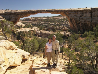
After watching the excellent film at the Visitor Center, we begin the 9-mile driving loop that takes us to each of the bridges. We start with the largest and finish with the thinnest. At each one we stop at the overlook and then make the short hike down into the canyon for an up close and personal look. Aimee refuses to stand under them; not since she read about the recent crash of Wall Arch in Arches National Park. It is a delightful day of short hikes. The weather is sunny and bright and the scenery simply stunning.
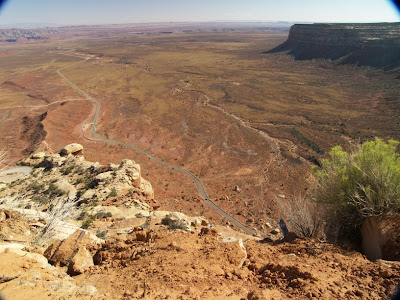
After spending most of the day at Natural Bridges, we head south toward the Arizona border for our final run to Tucson. After some thirty miles, the pavement ends and we make a sudden stop at the top of a sheer cliff seemingly the height of the Grand Canyon. Yes, the dirt road continues, down the cliff wall, via narrow switchbacks. WOW! This is both the coolest and the worst three miles of road we have traveled. This old mining road called Moki Dugway is America’s answer to Bolivia’s famed Death Road. After stopping first to awe at the road ahead, I slowly start down, careful not to brake hard and slide off, but quickly enough before some RV decides to pass going uphill. The road is not wide enough for two. With Aimee’s eyes closed, and thankfully only a few motorcycles going in the opposite direction, we make it to the bottom of the canyon. This turns out only to be the upper canyon.

A few miles down the road we meet up with the San Juan River and the Inner Gorge at Goosenecks State Park. Here we encounter the Granddaddy of entrenched meanders. At this small spot the San Juan River switchbacks three times at the bottom of a deep canyon. Simply Awesome. Unfortunately, the sun is right in our eyes and my photos are terrible. We are going to have to stay till sunrise. But there is no campground here, only a large unpaved parking lot. To Aimee’s dismay, I park the RV on the canyon lip and setup camp.

September 11, 2008

September 11, 2008

From the Mesa Verde area in southwestern Colorado, we drove west via back roads to the remote site of Hovenweep National Monument. Apparently it is not remote enough or there are plenty of nuts like me, because the parking lot is full. Hovenweep is one of many ancient Anasazi Indians ruins scattered around the Southwest. This one consists of several communities that built stone buildings atop the rims of local canyons. Aimee and I take a 2-mile hike around one of the canyons. There are only a handful of stone ruins left but it is clear they were defensive in nature, probably protecting the trickle of life-sustaining water in the canyon. The question is who were they afraid of? Themselves? Like elsewhere, the Anasazi villages were all abandoned around 1300 AD. I guess eventually the water dried up so much it wasn’t worth protecting anymore. One of the rim ruins we passed was called Twin Towers. It reminds us that today is 9-11 and makes us think about where we were on this day seven years ago.

From Hovenweep, we work our way northwest to Blanding, UT, where we visit the town’s Dinosaur Museum. Although small it is very nice, concentrating on only a few topics. One section is about dinosaur footprints. I was surprised to learn that dinosaur track fossils are very common and provide lots of information on dinosaur social behavior. They have found thousands between Denver and Texas, the site of an ancient seashore. So many that they think it used to be a dino migration route. Another section of the museum is on feathered dinosaurs and the evolution of birds from reptile ancestors. The last and most amusing is dinosaurs in film. That section brought back a lot of memories. We spend the night at an RV park two blocks away. Now that is convenient.
Newer Posts Older Posts